Machigasta | |
|---|---|
Municipality and village | |
| Country | |
| Province | La Rioja Province |
| Department | Arauco |
| Time zone | UTC−3 (ART) |
| Climate | BWh |
Machigasta is a municipality and village in La Rioja Province in northwestern Argentina. [1]
Machigasta | |
|---|---|
Municipality and village | |
| Country | |
| Province | La Rioja Province |
| Department | Arauco |
| Time zone | UTC−3 (ART) |
| Climate | BWh |
Machigasta is a municipality and village in La Rioja Province in northwestern Argentina. [1]

The Recovery Glacier is a glacier, at least 60 nautical miles long and 40 nautical miles wide at its mouth, flowing west along the southern side of the Shackleton Range in Antarctica.
The Behrendt Mountains is a group of mountains, 20 nautical miles long, aligned in the form of a horseshoe with the opening to the southwest, standing 7 nautical miles southwest of the Merrick Mountains in Ellsworth Land, Antarctica.

The Ames Range is a range of snow-covered, flat-topped, steep-sided mountains, extending in a north–south direction for 20 nautical miles and forming a right angle with the eastern end of the Flood Range in Marie Byrd Land, Antarctica.
Mikkelsen Bay is a bay, 15 nautical miles wide at its mouth and indenting 10 nautical miles, entered between Bertrand Ice Piedmont and Cape Berteaux along the west coast of Graham Land, Antarctica.

Aimogasta is a municipality and village in La Rioja Province in northwestern Argentina.
La Hoyada is a village and municipality in Catamarca Province in northwestern Argentina.
On the continent of Antarctica, the Aramis Range is the third range south in the Prince Charles Mountains, situated 11 miles southeast of the Porthos Range and extending for about 30 miles in a southwest–northeast direction. It was first visited in January 1957 by Australian National Antarctic Research Expeditions (ANARE) southern party led by W.G. Bewsher, who named it for a character in Alexandre Dumas' novel The Three Musketeers, the most popular book read on the southern journey.
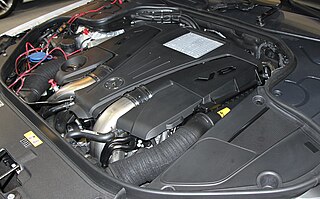
The Mercedes-Benz M278 is a family of direct injected, Bi-turbocharged, V8 gasoline automotive piston engines.
Balch Glacier is a glacier 9 nautical miles (17 km) long, on the east coast of Graham Land, flowing southeast into Mill Inlet, to the south of Gould Glacier.
Beaglehole Glacier is a glacier between Spur Point and Friederichsen Glacier on the east coast of Graham Land. It was named by the UK Antarctic Place-Names Committee after John Cawte Beaglehole, New Zealand historian of the Antarctic and biographer of Captain James Cook.
The Werner Mountains are a group of mountains located just west-southwest of New Bedford Inlet and between the Meinardus Glacier and Bryan Glacier, in Palmer Land, Antarctica.
The Cordiner Peaks are a group of peaks extending over an area of 6 nautical miles standing 8 nautical miles southwest of Dufek Massif in the northern part of the Pensacola Mountains, Antarctica.

Perutz Glacier is a glacier, 10 nautical miles (18 km) long and 2 nautical miles (3.7 km) wide, which flows west-northwest from Hemimont Plateau into Bourgeois Fjord, close east of Thomson Head, on the west coast of Graham Land, Antarctica. The mouth of the glacier was first surveyed in 1936 by the British Graham Land Expedition (BGLE) under Rymill. The entire glacier was surveyed in 1946-47 and 1948-49 by the Falkland Islands Dependencies Survey (FIDS), and named by them for Max F. Perutz of the Cavendish Laboratory, Cambridge, who has made important studies on the mechanism of glacier flow.
Mobiloil Inlet is an ice-filled inlet, nurtured by several northeast and east flowing glaciers, lying between the Rock Pile Peaks and Hollick-Kenyon Peninsula along the east coast of the Antarctic Peninsula.
Forbes Glacier is a glacier which flows from Hemimont Plateau west into the northeast corner of Square Bay, on the west coast of Graham Land, Antarctica. It is 10 nautical miles (19 km) long, 4 nautical miles (7 km) wide in its central part, and narrows to 2 nautical miles (4 km) at its mouth. The lower reaches of the glacier were first surveyed in 1936 by the British Graham Land Expedition under John Rymill. The survey was completed in 1946–48 by the Falkland Islands Dependencies Survey who named the glacier for James David Forbes, a Scottish physicist who was noted for his pioneer works on glaciology.

Hyde Glacier is a short glacier flowing east through the Edson Hills to join Union Glacier, in the Heritage Range, Antarctica. It was mapped by the United States Geological Survey from surveys and U.S. Navy air photos, 1961–66, and was named by the Advisory Committee on Antarctic Names for William H. Hyde, an ionospheric scientist at Little America V Station in 1958.
28°33′S66°48′W / 28.550°S 66.800°W
| | This article about a place in La Rioja Province, Argentina is a stub. You can help Wikipedia by expanding it. |