Related Research Articles
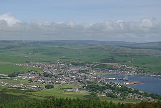
Campbeltown is a town and former royal burgh in Argyll and Bute, Scotland. It lies by Campbeltown Loch on the Kintyre Peninsula. Campbeltown became an important centre for Scotch whisky, and a busy fishing port.

The Campbeltown and Machrihanish Light Railway was a 2 ft 3 in narrow-gauge railway in Kintyre, Scotland, between Campbeltown and the coalmining village of Machrihanish. Only three other passenger-carrying lines in the UK operated on the same gauge, all of them in Wales - the Corris Railway, the short-lived Plynlimon and Hafan Tramway and the Talyllyn Railway.

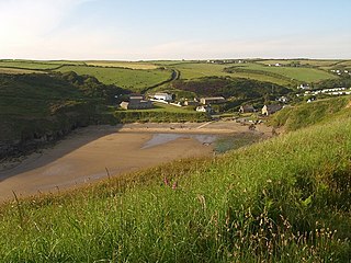
Machrihanish is a village in Argyll and Bute, on the west coast of Scotland. It is a short distance north of the tip of the Mull of Kintyre, which faces out towards Northern Ireland and the Atlantic.
The Somerset Coalfield in northern Somerset, England is an area where coal was mined from the 15th century until 1973. It is part of a larger coalfield which stretched into southern Gloucestershire. The Somerset coalfield stretched from Cromhall in the north to the Mendip Hills in the south, and from Bath in the east to Nailsea in the west, a total area of about 240 square miles (622 km2). Most of the pits on the coalfield were concentrated in the Cam Brook, Wellow Brook and Nettlebridge Valleys and around Radstock and Farrington Gurney. The pits were grouped geographically, with clusters of pits close together working the same coal seams often under the same ownership. Many pits shared the trackways and tramways which connected them to the Somerset Coal Canal or railways for distribution.
The South Yorkshire Coalfield is so named from its position within Yorkshire. It covers most of South Yorkshire, West Yorkshire and a small part of North Yorkshire. The exposed coalfield outcrops in the Pennine foothills and dips under Permian rocks in the east. Its most famous coal seam is the Barnsley Bed. Coal has been mined from shallow seams and outcrops since medieval times and possibly earlier.

The Pembrokeshire Coalfield in West Wales is one of the smallest British coalfields, but continuously worked from the 14th to 20th centuries. The main coalfield extends across south Pembrokeshire from Saundersfoot on Carmarthen Bay westwards to Broad Haven on St Brides Bay. A small detached portion of the field is centred on Newgale on St Brides Bay.
The Flintshire Coalfield in north-east Wales is one of the smaller British coalfields. It is in the county of Flintshire and extends from the Point of Ayr in the north, along the Dee Estuary through Connah's Quay to Caergwrle in the south. A small part extends onto the Wirral i.e. English coast of the estuary at Neston, Cheshire which was the site of a coalmine for a period. The coal-bearing strata continue southwards of Caergwrle as the Denbighshire Coalfield. Together the two coalfields are known as the North Wales Coalfield.
The Northumberland Coalfield is a coalfield in north-east England. It is continuous with the Durham Coalfield to its south. It extends from Shilbottle in the north to the boundary with County Durham along the River Tyne in the south, beyond which is the Durham Coalfield.
The Brora Coalfield is a coalfield on the east coast of Sutherland in northern Scotland. The 'Brora Main' is a 1m to 1.5m thick seam which has been mined in the Brora area. It is unusual amongst British coalfields in being of Jurassic age rather than Carboniferous. The first seams to be worked were those exposed along the North Sea coast though inland mining began in the early nineteenth century. Mining continued until the 1970s; its principal market being the nearby brickworks.

The Canonbie Coalfield is a small and largely concealed coalfield at Canonbie in the south of Scotland. A comprehensive survey by Peach and Horne was published in 1903. Canonbie colliery was worked until 1920, and another mine at Archerbeck continued until 1942.
The Midgeholme Coalfield is a coalfield in Midgeholme, on the border of Cumbria with Northumberland in northern England. It is the largest of a series of small coalfields along the south side of the Tyne Valley and which are intermediate between the Northumberland and Durham Coalfields to the east and the Cumberland Coalfield to the west. Like the other small coalfields to its east, this small outlier of the Coal Measures at Midgeholme occurs on the Stublick-Ninety Fathom Fault System, a zone of faults defining the northern edge of the Alston Block otherwise known as the North Pennines. It is recorded that coal was being mined at Midgeholme in the early seventeenth century. In the 1830s coal trains were being hauled from Midgeholme Colliery along the Brampton Railway by Stephenson's Rocket. The early workings have left a legacy of spoil heaps, bell pits, shafts and adits. There is no current coal production. However in January 2014, Northumberland County Council gave planning permission for the open-cast extraction of 37,000 tonnes of coal at Halton Lea Gate. This may open the way for other applications to mine the coalfield. In 1990 a proposal to mine reserves of 60,000 tonnes of good-quality coal at Lambley, Northumberland was rejected, but the prospect for a successful application has now changed, since the Planning Inspector allowed the development to proceed at Halton Lea Gate on appeal.
The Denbighshire Coalfield in the historic county of Denbighshire in north-east Wales is one of the smaller British coalfields. It extends from near Caergwrle in the north, southwards through Wrexham, Ruabon and Rhosllannerchrugog to Chirk in the south. A small part extends into Shropshire around Oswestry. Beyond Caergwrle the coal-bearing strata continue northwards as the Flintshire Coalfield. Together the two coalfields are known as the North Wales Coalfield.
The Warwickshire coalfield extends between Warwick and Tamworth in the English Midlands. It is about 25 miles (40 km) from north to south and its width is around half that distance. Its western margin is defined by the 'Western Boundary Fault'. In the northeast it abuts against steeply dipping shales of Cambrian age. The larger part of the outcrop at the surface consists of the Warwickshire Group of largely coal-barren red beds. Until its closure in 2013, the Daw Mill mine near Arley within the coalfield, was Britain's biggest coal-producer in the 21st century.
The Bristol Coalfield is a geologically complex coalfield in the west of England. Comprising the coal-bearing rocks arranged around the Coalpit Heath Syncline and Kingsdown Anticline, it extends beneath the eastern parts of the city of Bristol and northwards through southern Gloucestershire. The coalfield is sometimes referred to together with the Somerset Coalfield, which lies to its south, as the Bristol and Somerset Coalfield. There are also two outlying coal-mining areas, the Severn Coalfield and the Nailsea Basin which are described below.
The Midlothian Coalfield is a coalfield in southeast Scotland situated immediately to the east and southeast of Edinburgh. It is geologically continuous with the East Fife Coalfield beneath the Firth of Forth though the undersea coal reserves have only been partly exploited. There were undersea workings extending from Prestonlinks Colliery. The sulphur content of the majority of Midlothian coals is less than 1% making it especially suitable for modern requirements.
Thomas Lindsay Galloway MA, FRSE. FGS, AMInst, MInstME was the youngest son of William Galloway (1799–1854) shawl manufacturer and coal master of Paisley, Scotland and Margaret Lindsay (1818–1902). He was a civil and mining engineer and coal master of Argyll Colliery, Campbeltown, Kintyre, and like his brothers, Sir William Galloway and Robert Lindsay Galloway, he was also the author of several papers, lectures, designs and books.
The Pennine Coal Measures Group is a lithostratigraphical term referring to the coal-bearing succession of rock strata which occur in the United Kingdom within the Westphalian Stage of the Carboniferous Period. In formal use, the term replaces the Coal Measures Group as applied to the succession of coal-bearing strata within the Pennine Basin which includes all of the coalfields of northern England and the English Midlands. It includes the largely concealed Canonbie Coalfield of southern Scotland and the coalfields of northeast Wales and the minor Anglesey coalfield.
Nolton Haven is a hamlet halfway along the coast of St Bride's Bay in Pembrokeshire, Wales. It is included within the Pembrokeshire Coast National Park. Together with the larger inland village of Nolton which is about 1 km to the southeast and the village of Roch, Nolton Haven falls within Nolton and Roch community.

The coal industry in Wales played an important role in the Industrial Revolution in Wales. Coal mining in Wales expanded in the 18th century to provide fuel for the blast furnaces of the iron and copper industries that were expanding in southern Wales. The industry had reached large proportions by the end of that century, and then further expanded to supply steam-coal for the steam vessels that were beginning to trade around the world. The Cardiff Coal Exchange set the world price for steam-coal and Cardiff became a major coal-exporting port. The South Wales Coalfield was at its peak in 1913 and was one of the largest coalfields in the world. It remained the largest coalfield in Britain until 1925. The supply of coal dwindled, and pits closed in spite of a UK-wide strike against closures. Aberpergwm Colliery is the last deep mine in Wales.

The Campbeltown Heritage Centre is a museum and heritage centre in Campbeltown, Argyll, Scotland. The centre is the main repository for social history for the Kintyre Peninsula from around 1700 to the present day, and is run by the Kintyre Amenity Trust.
References
- ↑ British Geological Survey 2007 Bedrock geology: UK North 1:625,000 scale geological map, BGS, Keyworth, Notts
- ↑ Johnstone GS, 1966 British Regional Geology: The Grampian Highlands (3rd edn), HMSO/Institute of Geological Sciences, Edinburgh (p71)
- ↑ British Geological Survey, 1996. Campbeltown. Scotland sheet 12. S&D geology. 1:50,000 provisional series. (Keyworth, Nottingham: BGS)
- ↑ "Machrihanish Feature Page on Undiscovered Scotland".