
The Athabasca River is a river in Alberta, Canada, which originates at the Columbia Icefield in Jasper National Park and flows more than 1,231 km (765 mi) before emptying into Lake Athabasca. Much of the land along its banks is protected in national and provincial parks, and the river is designated a Canadian Heritage River for its historical and cultural importance. The scenic Athabasca Falls is located about 30 km (19 mi) upstream from Jasper.

The Mackenzie River is a river in the Canadian boreal forest. It forms, along with the Slave, Peace, and Finlay, the longest river system in Canada, and includes the second largest drainage basin of any North American river after the Mississippi.
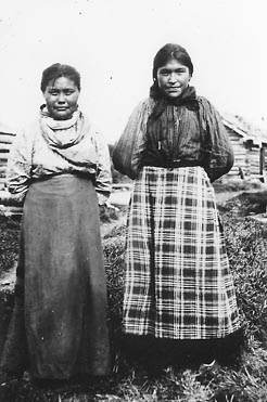
The Slavey are a First Nations indigenous peoples of the Dene group, indigenous to the Great Slave Lake region, in Canada's Northwest Territories, and extending into northeastern British Columbia and northwestern Alberta.

Lake Athabasca is in the north-west corner of Saskatchewan and the north-east corner of Alberta between 58° and 60° N in Canada. The lake is 26% in Alberta and 74% in Saskatchewan.

Great Slave Lake is the second-largest lake in the Northwest Territories of Canada, the deepest lake in North America at 614 m (2,014 ft), and the tenth-largest lake in the world by area. It is 469 km (291 mi) long and 20 to 203 km wide. It covers an area of 27,200 km2 (10,500 sq mi) in the southern part of the territory. Its given volume ranges from 1,070 km3 (260 cu mi) to 1,580 km3 (380 cu mi) and up to 2,088 km3 (501 cu mi) making it the 10th or 12th largest by volume.
Enterprise is a hamlet in the South Slave Region of the Northwest Territories, Canada, located between Great Slave Lake and the Alberta border on the Hay River.

The Peace River is a 1,923-kilometre-long (1,195 mi) river in Canada that originates in the Rocky Mountains of northern British Columbia and flows to the northeast through northern Alberta. The Peace River joins the Athabasca River in the Peace-Athabasca Delta to form the Slave River, a tributary of the Mackenzie River. The Finlay River, the main headwater of the Peace River, is regarded as the ultimate source of the Mackenzie River. The combined Finlay–Peace–Slave–Mackenzie river system is the 13th longest river system in the world.

The Slave River is a Canadian river that flows from the confluence of the Rivière des Rochers and Peace River in northeastern Alberta and empties into Great Slave Lake in the Northwest Territories. The river's name is thought to derive from the name for the Slavey group of the Dene First Nations, Deh Gah Got'ine, in the Athabaskan language. The Chipewyan had displaced other native people from this region.

The Radium King was built in 1937 to haul ore on the Mackenzie River, and her tributaries. This included uranium used in the US atom bombs of World War II. Later in her active career she hauled barges on Great Slave Lake.

The Mackenzie Northern Railway is a 602-mile (969 km) Canadian railway operating in Alberta and the Northwest Territories. It is the northernmost trackage of the contiguous North American railway network. Since being purchased by CN in 2006, the railway's mainline consists of the Slave Lake, Peace River, Manning, and the Meander River subdivisions.

Lake Claire is the largest lake which is entirely in Alberta, Canada. It is located entirely in Wood Buffalo National Park, west of Lake Athabasca. It lies between the mouths of Peace River and Athabasca River, and is part of the Peace-Athabasca Delta system.

The Northwest Territories is a territory in Northern Canada, specifically in Northwestern Canada between Yukon Territory and Nunavut including part of Victoria Island, Melville Island, and other islands on the western Arctic Archipelago. Originally a much wider territory enclosing most of central and northern Canada, the Northwest Territories was created in 1870 from the Hudson's Bay Company's holdings that were sold to Canada from 1869-1870. In addition, Alberta and Saskatchewan were formed from the territory in 1905. In 1999, it was divided again: the eastern portion became the new territory of Nunavut. Yellowknife stands as its largest city and capital. It has a population of 42,800 and has an area of 532,643 sq mi (1,379,540 km2). The current territory lies west of Nunavut, north of latitude 60° north, and east of Yukon.

Northern Alberta is a geographic region located in the Canadian province of Alberta.

The Mackenzie River in Canada's Northwest Territories is a historic waterway, used for centuries by Indigenous peoples, specifically the Dene, as a travel and hunting corridor. Also known as the Deh Cho, it is part of a larger watershed that includes the Slave, Athabasca, and Peace rivers extending from northern Alberta. In the 1780s, Peter Pond, a trader with the North West Company became the first known European to visit this watershed and begin viable trade with the Athapascan-speaking Dene of these rivers. The Mackenzie River itself, the great waterway extending to the Arctic Ocean, was first put on European maps by Alexander Mackenzie in 1789, the Scottish trader who explored the river. The watershed thus became a vital part of the North American fur trade, and before the advent of the airplane or road networks, the river was the only communication link between northern trading posts and the south. Water travel increased in the late 19th century as traders, dominated primarily by the Hudson's Bay Company (HBC), looked to increase water services in the Mackenzie River District.
Marine Transportation Services (MTS) formerly Northern Transportation Company Limited (NTCL) is a marine transportation company operating primarily in the Mackenzie River watershed of the Northwest Territories and northern Alberta, and the Arctic Ocean using a fleet of diesel tug boats and shallow-draft barges. NTCL filed for bankruptcy in 2016 and its assets were acquired by the Government of the Northwest Territories later that year.

The Horn River is a river in the Northwest Territories of Canada. It is a major tributary of the Mackenzie River.
The Radium Yellowknife is a Canadian tugboat. Like other vessels built for service on the MacKenzie River, its tributaries, and Great Bear Lake and Great Slave Lake, she was first built in a shipyard in Vancouver, British Columbia, then disassembled and shipped by rail to Waterways, Alberta. There she was reassembled and launched into Clearwater River on August 18, 1948 - late in the season, as the rivers used to freeze in late September or early October. Her reassembly was delayed initially by floods in the Fraser valley in May hindering transport, and then by a derailment of several of the railway cars carrying her components. After launch, she sailed to the portage on the Slave River at Fort Smith, Northwest Territories and was dragged overland across the portage to the lower river, where she could then access the Great Slave Lake, the MacKenzie River, and the Beaufort Sea.

GSI Mariner is a Canadian research/survey ship. She was built and used originally by Geophysical Service Inc. (GSI) to record seismic data on the Mackenzie River delta and the Beaufort Sea in the Arctic Ocean. Later she was owned by other companies, including Halliburton Canada. She is currently beached on the banks of the Mackenzie south of Inuvik, near the beginning of the Tuktoyaktuk Winter Road.
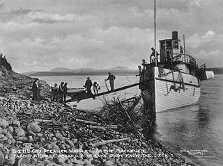
The Wrigley was a wooden steamship operated by the Hudson's Bay Company on the Mackenzie River, and its tributaries, including the Peel River, Great Slave Lake, and the lower reaches of the Slave River.
