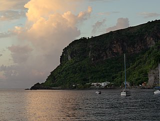
The Macoucheri River is a river on the Caribbean island of Dominica.
A river is a natural flowing watercourse, usually freshwater, flowing towards an ocean, sea, lake or another river. In some cases a river flows into the ground and becomes dry at the end of its course without reaching another body of water. Small rivers can be referred to using names such as stream, creek, brook, rivulet, and rill. There are no official definitions for the generic term river as applied to geographic features, although in some countries or communities a stream is defined by its size. Many names for small rivers are specific to geographic location; examples are "run" in some parts of the United States, "burn" in Scotland and northeast England, and "beck" in northern England. Sometimes a river is defined as being larger than a creek, but not always: the language is vague.
The Caribbean is a region of the Americas that consists of the Caribbean Sea, its islands and the surrounding coasts. The region is southeast of the Gulf of Mexico and the North American mainland, east of Central America, and north of South America.
Dominica, officially the Commonwealth of Dominica, is an island country in the West Indies. The capital, Roseau, is located on the western side of the island. It is geographically situated apart of the Leeward Islands chain in the Lesser Antilles archipelago in the Caribbean Sea. The island is located near Guadeloupe to the northwest and Martinique to the south-southeast. Its area is 750 km2 (290 sq mi), and the highest point is Morne Diablotins, at 1,447 m (4,747 ft) in elevation. The population was 71,293 at the 2011 census.
Portsmouth is the second largest town in Dominica, with 2,977 inhabitants. It lies on the Indian River on Dominica's northwest coast, in Saint John Parish. Cabrits National Park is located on a peninsula to the north of town. Portsmouth has its own sea port in Prince Rupert Bay.
Rosalie is a village in Dominica. It is located in Saint David Parish at the northern end of Rosalie Bay, on the central east coast of the island, close to the mouth of the Rosalie River.
Massacre is a town in Saint Paul Parish, Dominica, with about 1,200 inhabitants. It is located on the central west coast of the island, to the north of the capital, Roseau, on the Massacre River.
The Batali River is a river in Dominica. It rises on the southern slopes of Morne Diablotins, flowing southwest to reach the Caribbean Sea on the country's northwestern coast, close to the town of Barroui.
Mero is a small town in Saint Joseph Parish, Dominica. It is located in the west of the island, to the north of the mouth of the Layou River. To the north of Mero is Baroui and to the south of Mero is Saint Joseph.
The Balthazar River is a river in Dominica.
The Belfast River is a river on the Caribbean island of Dominica. Due to geothermal activity near the river's midpoint, parts of the river flow at near-boiling temperatures.
The Belle Fille River is a river on the Caribbean island of Dominica.
The Coulibistrie River is a river on the Caribbean island of Dominica. It flows from the interior westward through a deep valley, and empties into the Caribbean Sea north of Batalie Bay. It is fast-flowing, with small rapids and numerous bathing pools.
The Demitrie River is a river in Dominica.
The Delaford River is a river on the Caribbean island of Dominica.
The Indian River is a river on the Caribbean island of Dominica. It flows to the Caribbean Sea between the town of Portsmouth and the village of Glanvillia. It is the widest river in Dominica.
The Massacre River is a river on the Caribbean island of Dominica.
The Maréchal River is a river on the Caribbean island of Dominica.
The Mero River is a river in Dominica.
The Salée River is a river on the Caribbean island of Dominica.
The Salisbury River is a river on the Caribbean island of Dominica.
The Savane River is a river on the Caribbean island of Dominica.
The Tarou River is a river on the Caribbean island of Dominica near Mahaut.
Coulibistrie is a village on the west coast of Dominica, in the northwest corner of Saint Joseph Parish. It is between the villages of Colihaut to the north and Morne Rachette to the south. It extends inland from the coast within a deep valley, along both banks of the Coulibistrie River. It is primarily residential with few businesses. Many of the houses are built directly atop or adjoining the numerous large boulders that litter the valley along its base.
Coordinates: 15°25′N61°27′W / 15.417°N 61.450°W
A geographic coordinate system is a coordinate system that enables every location on Earth to be specified by a set of numbers, letters or symbols. The coordinates are often chosen such that one of the numbers represents a vertical position and two or three of the numbers represent a horizontal position; alternatively, a geographic position may be expressed in a combined three-dimensional Cartesian vector. A common choice of coordinates is latitude, longitude and elevation. To specify a location on a plane requires a map projection.
This article related to a river in Dominica is a stub. You can help Wikipedia by expanding it. |