This article needs additional citations for verification .(January 2017) |
Madaw or Madau is a village in Balkan Province in Turkmenistan. Its population as of 2013 was 10,215. [1]
This article needs additional citations for verification .(January 2017) |
Madaw or Madau is a village in Balkan Province in Turkmenistan. Its population as of 2013 was 10,215. [1]

The Arctic Archipelago, also known as the Canadian Arctic Archipelago, is an archipelago lying to the north of the Canadian continental mainland, excluding Greenland and Iceland.

Sera is a district located in Hiroshima Prefecture, Japan.
This is a list of the extreme points of the United Kingdom: the points that are farther north, south, east or west than any other location. Traditionally the extent of the island of Great Britain has stretched "from Land's End to John o' Groats".

Nisa was an ancient settlement of the Parthians, located near the Bagyr neighborhood of Ashgabat, Turkmenistan, 18 km west of the city center. Nisa is described by some as the first seat of the Arsacid Empire. It is traditionally assumed to have been founded by Arsaces I and was reputedly the royal residence of the Parthian kings, although it has not been established that the fortress at Nisa was either a royal residence or a mausoleum.
Merhabete is a woreda in Amhara Region, Ethiopia. Part of the Semien Shewa Zone, Merhabete is bordered on the south by Ensaro, on the west by the Oromia Region, on the north by Mida Woremo, on the east by Menz Keya Gebreal, and on the southeast by Moretna Jiru. The Jamma River defines this woreda's southern and eastern boundaries, and its tributary the Qechene defines its western and northern. The administrative center is Alem Ketema; other towns in this woreda include Fetira.

Vyšný Klátov is a village and municipality in Košice-okolie District in the Košice Region of eastern Slovakia.

The Constitution of Turkmenistan adopted on 18 May 1992 is the supreme law of Turkmenistan. In its preamble, the Constitution emphasizes self-determination for the Turkmen people, as well as the rule of law and rights for citizens..

Washington Air Route Traffic Control Center (ZDC) is an Area Control Center operated by the Federal Aviation Administration and located at Lawson Rd SE, Leesburg, Virginia, United States. The primary responsibility of ZDC is the separation of airplane flights and the expedited sequencing of arrivals and departures along STARs and SIDs for the Washington-Baltimore Metropolitan Area, the New York Metropolitan Area, and Philadelphia among many other areas.
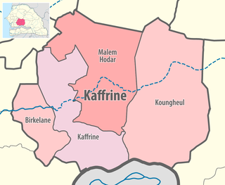
Birkilane department is one of the 46 departments of Senegal and is located in the Kaffrine region. It was created as part of the new region in 2008.
The former city of Dehistan/Mashhad-i Misrian, now in the Balkan Region of western Turkmenistan, was a major economic center from the 10th to the 14th centuries CE. The city lay on an important trade route of the states comprising Greater Iran.
Vvedensky, Vvedenskaya, or Vvedenskoye is the name of several rural localities in Russia.
Lahavere is a village in Põltsamaa Parish, Jõgeva County in eastern Estonia.

The Battle of Geok Tepe in 1881 was the main event in the 1880/81 Russian campaign to conquer the Teke tribe of Turkmens. Its effect was to give the Russian Empire control over most of what is now Turkmenistan, thereby nearly completing the Russian conquest of Central Asia.
Petrovsky, Petrovskaya, or Petrovskoye is the name of various inhabited localities in Russia.
Otradny, Otradnaya, or Otradnoye is the name of several inhabited localities in Russia.
Aksenovo or Aksyonovo (Аксёново) is the name of several rural localities in Russia.
Semyonovka is the name of several rural localities in Russia.
38°08′N54°45′E / 38.133°N 54.750°E
| | This Turkmenistan location article is a stub. You can help Wikipedia by expanding it. |