Mexazolam is a drug which is a benzodiazepine derivative. Mexazolam has been trialed for anxiety and was found to be effective in alleviating anxiety at one week follow-up, however, after three weeks of therapy mexazolam had lost its therapeutic anxiolytic properties becoming no more effective than placebo, presumably due to benzodiazepine tolerance. Mexazolam is metabolised via the CYP3A4 pathway. HMG-CoA reductase inhibitors including simvastatin, simvastatin acid, lovastatin, fluvastatin, atorvastatin and cerivastatin inhibit the metabolism of mexazolam, but not the HMG-CoA reductase inhibitor pravastatin.
Plymouth South High School, also known as Plymouth South, or PSHS, is a public high school located in Plymouth, Massachusetts. Its students are residents of the town of Plymouth. Plymouth South is one of two high schools in Plymouth, the other being Plymouth North High School. Plymouth South is located near the Long Pond neighborhood of Plymouth, west of Route 3 and The Pinehills development, and also adjacent to nearby Myles Standish State Forest, which is the biggest publicly owned recreation area in the South Shore region of Massachusetts, and also one of the biggest in the state. The school colors are Black, Teal and White and the school's teams are the Panthers.
The United States District Court for the Canal Zone was a United States District Court that existed in Panama from 1914 to 1982.
Caminaca District is one of fifteen districts of the province Azángaro in Peru.
San Juan de Salinas District is one of fifteen districts of the province Azángaro in Peru.

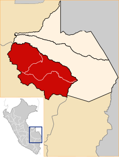
Coata District is one of fifteen districts of the province Puno in Peru.

Vilque District is one of fifteen districts of the province Puno in Peru. Vilque was the location of the major fair during the nineteenth century of goods from Bolivia and Argentina and especially for mules from Salta.
Santa Rosa District is one of nine districts of the province Melgar in Peru.
Umachiri District is one of nine districts of the province Melgar in Peru.
San José de Sisa District is one of five districts of the province El Dorado in Peru.
Kałęczyn-Walochy is a village in the administrative district of Gmina Rutki, within Zambrów County, Podlaskie Voivodeship, in north-eastern Poland.
Lipa-Miklas is a village in the administrative district of Gmina Lipsko, within Lipsko County, Masovian Voivodeship, in east-central Poland.

Dhamilikuwa is a village development committee in Lamjung District in the Gandaki Zone of northern-central Nepal. At the time of the 1991 Nepal census it had a population of 3831 people living in 791 individual households.
Pszczółki is a settlement in the administrative district of Gmina Mikołajki, within Mrągowo County, Warmian-Masurian Voivodeship, in northern Poland.
Litwinki is a village in the administrative district of Gmina Nidzica, within Nidzica County, Warmian-Masurian Voivodeship, in northern Poland.
The West Branch Piscataquis River is a 22-mile-long (35 km) tributary of the Piscataquis River in Piscataquis County, Maine. Its source is in East Moxie, Somerset County . The river runs about 6 miles (10 km) east, then 11 miles (18 km) south, then 5 miles (8 km) east to its confluence with the East Branch Piscataquis River in Blanchard to form the Piscataquis.

Krong Preah Sihanouk is one of four districts of Preah Sihanouk Province in Cambodia. According to the 1998 census of Cambodia, it had an urban population of 67,440. In addition to Sihanoukville City and the Autonomous port, the islands Koh Puos, Koh Preab, Koh Doung, Koh Kaong Kang, Koh Tres, Koh Koun, Koh Tuich, Koh Rong and Koh Rong Sanloem are under Krong Preah Sihanouk administration. Its urban character, commerce and industry, tourism and a high number of international residents cause this district's extraordinary position in comparison with surrounding administrative units.
Sarmiyeh is a Syrian village located in Jubb Ramlah Subdistrict in Masyaf District, Hama. According to the Syria Central Bureau of Statistics (CBS), Sarmiyeh had a population of 2953 in the 2004 census.
Valle de Agua Arriba is a corregimiento in Changuinola District, Bocas del Toro Province, Panama. It has a land area of 70.3 square kilometres (27.1 sq mi) and had a population of 3,163 as of 2010, giving it a population density of 45 inhabitants per square kilometre (120/sq mi). It was created by Law 18 of February 26, 2009.
Santo Tomás is a corregimiento in Alanje District, Chiriquí Province, Panama. It has a land area of 45.1 square kilometres (17.4 sq mi) and had a population of 1,259 as of 2010, giving it a population density of 27.9 inhabitants per square kilometre (72/sq mi). Its population as of 1990 was 721; its population as of 2000 was 840.