Unorganized North Algoma District is an unorganized area in northeastern Ontario, Canada, comprising all areas in Algoma District, north of the Sault Ste. Marie to Elliot Lake corridor, which are not part of an incorporated municipality or a First Nation. It covers 44,077.03 km2 (17,018.24 sq mi) of land, and had a population of 5739 in 2016.
Chakari is a mining village in the province of Mashonaland West, Zimbabwe. It is located about 33 km west of Chegutu and 38 km north of Kadoma. According to the 1982 Population Census, the village had a population of 8,415. The village grew up around the Turkois Mine in 1907 and was named after the mine. In 1911 it was renamed Shagari but the name was changed again in 1923 to its current name, Chakari. Gold is still mined at the Dalny Mine which is one of Zimbabwe's largest producers of gold. Maize, wheat, sorghum, barley and cotton are grown in the area. This area has red soil that is high is minerals that makes it great for farming crops.

Vihiga County is an administrative region in the former Western Province of Kenya whose headquarters are in Mbale, the largest town in the county. The county has a population of 554,622 and an area of 563 km². Vihiga County was split from Kakamega County in 1990.

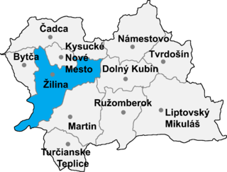
Ďurčiná is a village and municipality in Žilina District in the Žilina Region of northern Slovakia.

Sipiory is a village in the administrative district of Gmina Kcynia, within Nakło County, Kuyavian-Pomeranian Voivodeship, in north-central Poland. It lies approximately 9 kilometres (6 mi) north of Kcynia, 10 km (6 mi) south-west of Nakło nad Notecią, and 32 km (20 mi) west of Bydgoszcz.

Rynarzewo is a village in the administrative district of Gmina Szubin, within Nakło County, Kuyavian-Pomeranian Voivodeship, in north-central Poland. It lies approximately 8 kilometres (5 mi) north-east of Szubin, 18 km (11 mi) south-east of Nakło nad Notecią, and 14 km (9 mi) south-west of Bydgoszcz.

Samoklęski Małe is a village in the administrative district of Gmina Szubin, within Nakło County, Kuyavian-Pomeranian Voivodeship, in north-central Poland. It lies approximately 6 kilometres (4 mi) north of Szubin, 12 km (7 mi) south-east of Nakło nad Notecią, and 20 km (12 mi) west of Bydgoszcz.

Ratowo is a village in the administrative district of Gmina Mogilno, within Mogilno County, Kuyavian-Pomeranian Voivodeship, in north-central Poland. It lies approximately 9 kilometres (6 mi) east of Mogilno, 51 km (32 mi) south of Bydgoszcz, and 55 km (34 mi) south-west of Toruń.

Cerăt is a commune in Dolj County, Romania with a population of 4,077 people. It is composed of two villages, Cerăt and Malaica.

Frumușița is a commune in Galați County, Romania with a population of 5,165 people. It is composed of three villages: Frumușița, Ijdileni and Tămăoani.

Czarniewo is a village in the administrative district of Gmina Sztabin, within Augustów County, Podlaskie Voivodeship, in north-eastern Poland. It lies approximately 4 kilometres (2 mi) south-west of Sztabin, 22 km (14 mi) south of Augustów, and 62 km (39 mi) north of the regional capital Białystok.

Babczów is a village in the administrative district of Gmina Kobiele Wielkie, within Radomsko County, Łódź Voivodeship, in central Poland. It lies approximately 5 kilometres (3 mi) north-east of Kobiele Wielkie, 16 km (10 mi) east of Radomsko, and 81 km (50 mi) south of the regional capital Łódź.

Dąbrowa Rzeczycka is a village in the administrative district of Gmina Radomyśl nad Sanem, within Stalowa Wola County, Subcarpathian Voivodeship, in south-eastern Poland. It lies approximately 9 kilometres (6 mi) east of Radomyśl nad Sanem, 10 km (6 mi) north of Stalowa Wola, and 71 km (44 mi) north of the regional capital Rzeszów.

Żaków is a village in the administrative district of Gmina Siennica, within Mińsk County, Masovian Voivodeship, in east-central Poland. It lies approximately 15 kilometres (9 mi) south-east of Mińsk Mazowiecki and 49 km (30 mi) east of Warsaw.

Zatorowizna is a village in the administrative district of Gmina Lubowidz, within Żuromin County, Masovian Voivodeship, in east-central Poland. It lies approximately 14 kilometres (9 mi) south-west of Lubowidz, 16 km (10 mi) west of Żuromin, and 131 km (81 mi) north-west of Warsaw.

Dąbrowa is a village in the administrative district of Gmina Brudzew, within Turek County, Greater Poland Voivodeship, in west-central Poland. It lies approximately 5 kilometres (3 mi) east of Brudzew, 13 km (8 mi) north-east of Turek, and 125 km (78 mi) east of the regional capital Poznań.

Koźmin is a village in the administrative district of Gmina Brudzew, within Turek County, Greater Poland Voivodeship, in west-central Poland. It lies approximately 5 kilometres (3 mi) east of Brudzew, 13 km (8 mi) north-east of Turek, and 125 km (78 mi) east of the regional capital Poznań.

Własna is a village in the administrative district of Gmina Starcza, within Częstochowa County, Silesian Voivodeship, in southern Poland. It lies approximately 2 kilometres (1 mi) east of Starcza, 16 km (10 mi) south of Częstochowa, and 47 km (29 mi) north of the regional capital Katowice.

Jeninek is a village in the administrative district of Gmina Bogdaniec, within Gorzów County, Lubusz Voivodeship, in western Poland. It lies approximately 2 kilometres (1 mi) south of Bogdaniec and 15 km (9 mi) south-west of Gorzów Wielkopolski.


