History
Mahmudlu village is located in the North-West of Azerbaijan in Shamkir district, 21 kilometers from the center of the district, on the right bank of the Shamkir river, on the Ganja-Gazakh plain. The population is 3259 people (as at 1 January 2005). The economy is based on animal husbandry, crop production, vineculture and horticulture. The village has a high school, a club, a library, a medical center, an ancient cemetery, a bridge, a monument to the martyrs, several artesians, various commercial and domestic facilities. The village has historically consisted of nine small tribes madmudlu, mashadigurbanli, kelbali, allakululi, gazakhli, yekenamazli, pusteli, yarakhmedli, gadzhymamedli. During the collectivization of the twentieth century, these tribes were moved to one place, and the settlement was named after the mahmudlu tribe. There was a time when this village was impenetrable jungle. Representatives of the Turkic-speaking of Mahmudlu tribe arrived in Azerbaijan at different times. The sources also referred to the inhabitants of Mahmudlu, who spend their winter in Nagorno-Karabakh and summer in Zangezur. Mahmudli people living in the East of lake Van in Turkey, came to the Caucasus in the XVI-XVII centuries, including in Azerbaijan. Don Juan of Persia named mahmudlu tribe in 25th place in the list of gizilbash tribes and their branches. There are also Mahmudlu villages in Jabrail, Fuzuli and Gubadli districts. In the Zangezur district of Ganja (now Gafan district), Mahmudlu village was abandoned (in 1988 its population was expelled).

Gadabay District is one of the 66 districts of Azerbaijan. It is located in the west of the country and belongs to the Ganja-Qazakh Economic Region. The district borders the districts of Dashkasan, Shamkir, Tovuz, and the Gegharkunik and Tavush provinces of Armenia. The Artsvashen exclave of Armenia is surrounded by the Gadabay District and is de facto controlled by Azerbaijan, administrated as part of Goranboy District. Its capital and largest city is Gadabay. As of 2020, the district had a population of 109,900.
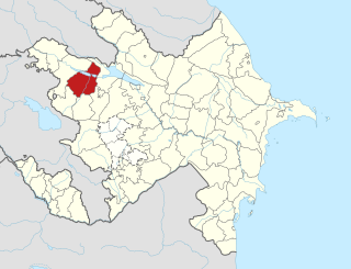
Shamkir District is one of the 66 districts of Azerbaijan. It is located in the north-west of the country and belongs to the Ganja-Qazakh Economic Region. The district borders the districts of Gadabay, Tovuz, Samukh, Goygol, and Dashkasan. Its capital and largest city is Shamkir. As of 2020, the district had a population of 219,500.

Shamkir is a city in and the capital of Shamkir District in western Azerbaijan, located in the northern foothills of the Lesser Caucasus, on the coast of the Chagirchay River on Tbilisi-Yevlakh highway, about 4 kilometers (2.5 mi) from Dallar railway station. It is the eighth largest city in Azerbaijan by population.

Gənzə is a village and municipality in the Ordubad District of Nakhchivan, Azerbaijan. It is located 12 km in the north-east from the district center. Its population is busy with gardening and animal husbandry. There are secondary school, club, library and a medical center in the village. It has a population of 1,380.
Qızılca is a village and municipality in the Julfa District of Nakhchivan, Azerbaijan. It is located 22 km in the north from the district center, on the slope of the Zangezur ridge. Its population is busy with vine-growing, grain-growing and animal husbandry. There are secondary school, club, library, and a medical center in the village. It has a population of 439.
Qahab is a village and municipality in the Babek District of Nakhchivan, Azerbaijan. It is located in the 2 km from the Nakhchivan-Sirab highway, 15 km in the north-east from the district center, on the slope of the Zangezur range. Its population is busy with grain-growing, beekeeping and animal husbandry. There are secondary school, club, library, mosque and culture house in the village. It has a population of 2,691.
Milax is a village and municipality in the Julfa District of Nakhchivan, Azerbaijan. It is located 55 km in the north from the district center, on the right bank of the Alinjachay River, on the slope of the Zangezur ridge. Its population is busy with farming and animal husbandry. There are secondary school, cultural house, kindergarten, library, communication branch, and a medical center in the village. It has a population of 924. The Zoğala settlement and necropolis of the ancient and Middle Ages were discovered in the north-west from the village.
Ərəfsə is a village and municipality in the Julfa District of Nakhchivan, Azerbaijan. It is located 55 km in the north from the district center, on the right bank of the Alinjachay River, on the slope of the Zangezur ridge. Its population is busy with vine-growing, grain-growing and animal husbandry. There are a secondary school, a cultural house, two libraries, a communication center, and a medical center in the village. It has a population of 940.
Keçili is a village and the most populous municipality, except for the capital Şahbuz, in the Shahbuz District of Nakhchivan, Azerbaijan. It is located 20 km north of the district center, on the slope of the Zangezur ridge. Its population is busy with gardening and animal husbandry. There are a secondary school, library, culture house, club and hospital in the village. It has a population of 1,702. Nearby are registered the place of residence of the medieval, Kollug and the place of residence of the medieval, Kechili.
Gömür is a village and municipality in the Shahbuz District of Nakhchivan, Azerbaijan. It is located 20 km in the east from the district center, on the slope of the ridge of Zangezur. Its population is busy basically with animal husbandry. There are secondary school, library, club and a medical center in the village. It has a population of 482.
Yuxarı Qışlaq is a village and municipality in the Shahbuz District of Nakhchivan, Azerbaijan. It is located 17 km in the north-east from the district center, on the bank of the Yukhary Kyshlak River. Its population is busy with gardening and animal husbandry. There are secondary school, club, library and a medical center in the village. It has a population of 535. Nearby, registered the Kelekli II settlement of the Middle Ages.
Biçənək is a village and municipality in the Shahbuz District of Nakhchivan, Azerbaijan. It is located in the near of the Yevlakh-Lachin-Nakhchivan highway, 24 km in the north-east from the district center, on both banks of the Nakhchivanchay river. Its population is busy with gardening and animal husbandry. There are a secondary school, club, library and a medical center in the village. It has a population of 1,172. Nearby in the east is located old Farhad house and the Xınzirək, the place of residence of the Middle Ages.
Qarxun is a village and municipality in the Sharur District of Nakhchivan, Azerbaijan. It is located in the near of the Sharur-Nakhchivan highway, 3 km away from the district center, on the right bank of the Arpachay River, on the plain. Its population is busy with grain-growing, vegetable-growing, beet-growing and animal husbandry. There are the iron - concrete products and gravel separating factories, secondary school, cultural house, kindergarten and a hospital in the village. It has a population of 1,924.
Unus is a village and municipality in the Ordubad District of Nakhchivan, Azerbaijan. It is located 33 km in the north-west from the district center, on the slope of the Zangezur ridge. Its population is busy with gardening, farming and animal husbandry. There are secondary school, library, club and a medical center in the village. It has a population of 743.
Parağa is a village and municipality in the Ordubad District of Nakhchivan, Azerbaijan. It is located in the near of the Ordubad-Tivi highway, 48 km in the north-west from the district center, on the left bank of the Gilanchay river, on the slope of the Zangezur ridge. Its population is busy with gardening, vegetable-growing, animal husbandry. There are secondary school, club, library and a medical center in the village. It has a population of 306.
Teyvaz is a village and municipality in the Julfa District of Nakhchivan, Azerbaijan. It is located 57 km in the north from the district center, on the right bank of the Alinjachay River, on the slope of the Zangezur ridge. Its population is busy with farming and animal husbandry. There are secondary school, club, library, kindergarten and a medical center in the village. It has a population of 350.
Muğanlı is a village and municipality in the Sharur District of Nakhchivan Autonomous Republic, Azerbaijan. It is located 4 km away from the district center, on the plain. Its population is busy with grain-growing, tobacco-growing, vegetable-growing, foddering, vine-growing and animal husbandry. There are secondary school, library, club, mosque and a medical center in the village. It has a population of 1,090.
Vələver is a village and municipality in the Ordubad District of Nakhchivan, Azerbaijan. It is located 27 km in the north-east from the district center, on the slope of the Zangezur ridge. Its population is busy with gardening, vegetable-growing and animal husbandry. There are secondary school, library, club and a medical center in the village. It has a population of 468.
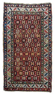
Ganja rugs or Geunge rugs are a category of Caucasian rug from the town of Gəncə, Azerbaijan, also written Geunge, Gendje or Ganja. Gəncə is located between the weavings areas of Karabagh, Kazakh and Shirvan and it also acted as a marketing centre for weaving from those surrounding areas.
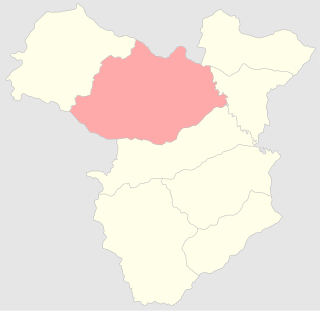
The Elisabethpol Uyezd, also transliterated as Yelizabetpolskiy Uyezd, and known as Ganja Uyezd was one of the uyezds of Elisabethpol Governorate of the Russian Empire and then of Azerbaijan Democratic Republic with its center in Elisabethpol (Ganja) from 1840 until its formal abolition in 1929 by Soviet authorities. The area of the Elisabethpol Uyezd corresponds to the contemporary Gadabay, Shamkir, Dashkasan, Goygol, Ganja Districts of Azerbaijan, and the Artsvashen enclave of Armenia.

