Majavatn

Last updated
Majavatn
Village
Norway Nordland location map.svg
Red pog.svg
Majavatn
Location in Nordland
Norway location map.svg
Red pog.svg
Majavatn
Majavatn (Norway)
Coordinates: 65°10′03″N13°22′09″E / 65.1676°N 13.3691°E / 65.1676; 13.3691 Coordinates: 65°10′03″N13°22′09″E / 65.1676°N 13.3691°E / 65.1676; 13.3691
Country Norway
Region Northern Norway
County Nordland
District Helgeland
Municipality Grane
Elevation
[1]
321 m (1,053 ft)
Time zone UTC+01:00 (CET)
  Summer (DST) UTC+02:00 (CEST)
Post Code
8680 Trofors

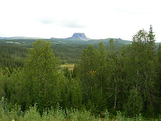
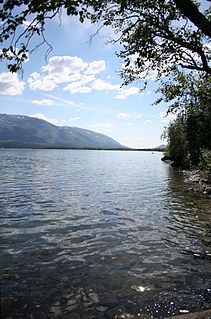
Majavatn is a village in the municipality of Grane in Nordland county, Norway. It is located on the eastern shore of the lake Majavatnet, just west of the boundary of Børgefjell National Park. The village of Leiren lies about 30 kilometres (19 mi) to the northeast and the municipal center of Trofors lies about 45 kilometres (28 mi) to the north.

Grane, Nordland Municipality in Nordland, Norway

Grane  is a municipality in Nordland county, Norway. It is part of the Helgeland traditional region. The administrative centre of the municipality is the village of Trofors. There are several other villages including Fallmoen, Leiren, Majavatn, and Strendene. European route E06 highway and the Nordland Line run through the municipality from south to north.

Nordland County (fylke) of Norway

Nordland is a county in Norway in the Northern Norway region, bordering Troms in the north, Trøndelag in the south, Norrbotten County in Sweden to the east, Västerbotten County to the southeast, and the Atlantic Ocean to the west. The county was formerly known as Nordlandene amt. The county administration is in Bodø. The remote Arctic island of Jan Mayen has been administered from Nordland since 1995.

Norway constitutional monarchy in Northern Europe

Norway, officially the Kingdom of Norway, is a Nordic country in Northern Europe whose territory comprises the western and northernmost portion of the Scandinavian Peninsula; the remote island of Jan Mayen and the archipelago of Svalbard are also part of the Kingdom of Norway. The Antarctic Peter I Island and the sub-Antarctic Bouvet Island are dependent territories and thus not considered part of the kingdom. Norway also lays claim to a section of Antarctica known as Queen Maud Land.

View of the lake near the village Majavatn.JPG
View of the lake near the village

Both European route E6 highway and the Nordland Line pass through the village of Majavatn. Majavatn Station is the local railway station. It lies 321.74 kilometres (199.92 mi) from Trondheim and it sits at an elevation of 319.9 metres (1,050 ft) above sea level. Majavatn Church is located in the village and serves the southern part of the municipality.

European route E6 highway in Sweden and Norway

European route E6 is the main north-south road through Norway, and the west coast of Sweden. It is 3 088 km long and runs from the southern tip of Sweden at Trelleborg, into Norway and through almost all of the country north to the Arctic Circle and Nordkapp. The route ends in Kirkenes close to the Russian border.

Nordland Line railway line in Norway

The Nordland Line is a 729-kilometer (453 mi) railway line between Trondheim and Bodø, Norway. It is the longest in Norway and lacks electrification. The route runs through the counties of Trøndelag and Nordland, carrying a combination of commuter, long-haul passenger and freight trains. From Trondheim Central Station to Steinkjer Station the line is most heavily used, with hourly services by the Trøndelag Commuter Rail. There are three branch lines—the Stavne–Leangen Line at Leangen Station, the Meråker Line at Hell Station and the Namsos Line at Grong Station.

Trondheim City in Norway

Trondheim is a city and municipality in Trøndelag county, Norway. It has a population of 193,501, and is the third-most populous municipality in Norway, although the fourth largest urban area. Trondheim lies on the south shore of Trondheim Fjord at the mouth of the River Nidelva. The city is dominated by the Norwegian University of Science and Technology (NTNU), the Foundation for Scientific and Industrial Research (SINTEF), St. Olavs University Hospital and other technology-oriented institutions.

Southern Sami reindeer herders drive their reindeer through the area around Majavatn. [2]

Reindeer A species of mammals belonging to the deer, muntjac, roe deer, and moose family of ruminants

The reindeer, also known as the caribou in North America, is a species of deer with circumpolar distribution, native to Arctic, sub-Arctic, tundra, boreal, and mountainous regions of northern Europe, Siberia, and North America. This includes both sedentary and migratory populations. Rangifer herd size varies greatly in different geographic regions. The Taimyr herd of migrating Siberian tundra reindeer in Russia is the largest wild reindeer herd in the world, varying between 400,000 and 1,000,000. What was once the second largest herd is the migratory boreal woodland caribou George River herd in Canada, with former variations between 28,000 and 385,000. As of January 2018, there are fewer than 9,000 animals estimated to be left in the George River herd, as reported by the Canadian Broadcasting Corporation. The New York Times reported in April 2018 of the disappearance of the only herd of southern mountain caribou in the lower 48 states, with an expert calling it "functionally extinct" after the herd's size dwindled to a mere three animals.

During the Second World War there were confrontations between Germans and Norwegian citizens at Tangen farm. Many of the Norwegians involved were later executed by the Germans at Falstad concentration camp in 1942. These events were later known as the Majavatn affair. [2]

Germany Federal parliamentary republic in central-western Europe

Germany, officially the Federal Republic of Germany, is a country in Central and Western Europe, lying between the Baltic and North Seas to the north, and the Alps, Lake Constance and the High Rhine to the south. It borders Denmark to the north, Poland and the Czech Republic to the east, Austria and Switzerland to the south, France to the southwest, and Luxembourg, Belgium and the Netherlands to the west.

Falstad concentration camp WWII Concentration Camp in Trøndelag, Norway

Falstad concentration camp was situated in the village of Ekne in what was the municipality of Skogn in Norway. It was used mostly for political prisoners from Nazi-occupied territories.

Related Research Articles

Bodø Municipality in Nordland, Norway

Bodø is a municipality in Nordland county, Norway. It is part of the traditional region of Salten. The administrative centre of the municipality is the town of Bodø. Some of the notable villages in Bodø include Misvær, Skjerstad, Saltstraumen, Løding, Løpsmarka, Kjerringøy, Sørvær, and Fenes.

Bindal Municipality in Nordland, Norway

Bindal is a municipality in the Helgeland region in the extreme southwest part of Nordland county, Norway. The administrative centre is the village of Terråk. Other villages include Bindalseidet, Holm, Vassås, Horsfjord and Åbygda.

Brønnøy Municipality in Nordland, Norway

Brønnøy is a municipality in Nordland county, Norway. It is part of the Helgeland region. The administrative centre and commercial centre of the municipality is the town of Brønnøysund. A secondary centre is the village of Hommelstø. Other villages include Tosbotn, Lande, Trælnes, and Indreskomo.

Hattfjelldal Municipality in Nordland, Norway

Hattfjelldal is a municipality in Nordland county, Norway. It is part of the Helgeland traditional region. The administrative centre of the municipality is the village of Hattfjelldal. Other villages include Grubben, Svenskvollen, and Varntresk. Hattfjelldal Airfield is located in the village of Hattfjelldal.

Fiskelausvatnet (Grane) lake in Grane, Norway

Fiskelausvatnet (Norwegian) or Guelehtsjaevrie (Southern Sami) is a lake that lies in the municipality of Grane in Nordland county, Norway. The lake lies in the northern part of Grane, about 13 kilometres (8.1 mi) northeast of Trofors. The name of the lake translates as "fishless lake".

Gresvatnet lake on Norway-Sweden border

Gresvatnet (Norwegian) or Gräsvattnet (Swedish) or Graesiejaevrie (Southern Sami) is a lake on the border between Norway and Sweden. Most of the lake lies in Hemnes Municipality in Nordland county (Norway) and then a small portion crosses the border into Storuman Municipality in Västerbotten County (Sweden). The lake lies about 25 kilometres (16 mi) east of the village of Korgen, and just a few kilometres northeast of the mountain Oksskolten and the Okstindbreen glacier. The lake is one of the upper reservoirs for the Bjerka Hydroelectric Power Station.

Majavatnet lake in Grane, Norway

Majavatnet (Norwegian) or Maajehjaevrie (Southern Sami) is a lake in the municipality of Grane in Nordland county, Norway. The 16.6-square-kilometre (6.4 sq mi) lake lies just west of Børgefjell National Park in southern Grane. The village of Majavatn lies on the eastern shore of the lake. European route E06 and the Nordland Line both run along the eastern shore of the lake.

Mellingsvatnet lake in Namsskogan and Grane, Norway

Mellingsvatnet (Norwegian) or Veelnjesjaevrie (Southern Sami) is a 4.47-square-kilometre (1.73 sq mi) lake in Norway. The lake lies in the municipalities of Namsskogan and Grane. The lake lies about 1.5 kilometres (0.93 mi) west of the European route E6 highway on the border of the two municipalities.

Nedre Fiplingvatnet lake in Grane, Norway

Nedre Fiplingvatnet (Norwegian) or Fijhpelogkoe (Southern Sami) is a lake that lies in the municipality of Grane in Nordland county, Norway. The 10.5-square-kilometre (4.1 sq mi) lake lies just west of Børgefjell National Park. The village of Leiren is located about 4 kilometres (2.5 mi) north of the lake.

Ranseren lake on the border of Norway-Sweden

Ranseren (Norwegian), also known as Bije-Ransarn (Swedish) or Bijjie Raentsere (Southern Sami), is a lake on the border between Norway and Sweden. The Norwegian side lies in Hattfjelldal Municipality in Nordland county. The Swedish side of the lake is called Bije-Ransaren, which means "the upper Ransaren" and this part lies in Vilhelmina Municipality in Västerbotten County.

Sefrivatnet lake in Grane, Norway

Sefrivatnet (Norwegian) or Sohkerde (Southern Sami) is a lake that lies in the municipality of Grane in Nordland county, Norway. The 2.36-square-kilometre (0.91 sq mi) lake lies between the lakes Majavatnet and Storsvenningvatnet. European route E06 and the Nordland Line both run along the eastern edge of the lake.

Storsvenningvatnet lake in Grane, Norway

Storsvenningvatnet (Norwegian) or Svijjege (Southern Sami) is a lake that lies in the municipality of Grane in Nordland county, Norway. It lies about halfway between the villages of Trofors and Majavatn. The European route E06 highway runs along the eastern side of the lake. The lake Gåsvatnet lies 4 kilometres (2.5 mi) to the west of Storsvenningvatnet and the large lake Nedre Fiplingvatnet lies 7 kilometres (4.3 mi) to the east.

Trofors Village in Northern Norway, Norway

Trofors is the administrative centre of the municipality of Grane in Nordland county, Norway. It is located at the confluence of the rivers Austervefsna and Svenningdalselva which forms the large river Vefsna. The village of Leiren lies about 25 kilometres (16 mi) to the southeast and the village of Majavatn lies about 45 kilometres (28 mi) to the south.

During the occupation of Norway by Germany, the occupying powers imposed martial law in Trondheim and surrounding areas effective October 6, 1942 through October 12, 1942. During this time, 34 Norwegians were killed by extrajudicial execution. This also served as a pretext for the arrest and detention of all male Jewish inhabitants of the area as part of the Holocaust in Norway.

Lomsdal–Visten National Park national park in Norway

Lomsdal–Visten National Park is a Norwegian national park that was established on 26 June 2009. The park consists of a total protected area of 1,102 square kilometres (425 sq mi). It is located in Nordland county, Norway, and covers parts of the municipalities of Brønnøy, Vevelstad, Grane, and Vefsn.

Tosbotn Village in Northern Norway, Norway

Tosbotn or Tosbotnet is a village in the municipality of Brønnøy in Nordland county, Norway. The village is located at the end of the Tosenfjord arm of the Bindalsfjorden. The village is mostly a tourist center. It is located along Norwegian County Road 76, north of the village of Lande and just east of the 6-kilometre (3.7 mi) long Tosen Tunnel which connects Brønnøy to the European route E6 highway in Grane Municipality.

Leiren Village in Northern Norway, Norway

Leiren or Leira is a village in the municipality of Grane in Nordland county, Norway. The village is located at the northern end of the lake Nedre Fiplingvatnet. The municipal center of Trofors lies about 25 kilometres (16 mi) to the northwest and the village of Majavatn lies about 30 kilometres (19 mi) to the south. The local Fiplingdal Church is located in Leiren, serving the eastern part of Grane.

Majavatn Church Church in Nordland, Norway

Majavatn Church is a chapel of the Church of Norway in Grane Municipality in Nordland county, Norway. It is located in the village of Majavatn, about 50 kilometres (31 mi) south of the village of Trofors, just alongside the large lake Majavatnet. It is an annex chapel for the Grane parish which is part of the Indre Helgeland prosti (deanery) in the Diocese of Sør-Hålogaland. The white, wooden chapel was built in a long church style in 1915 as the "Majavatn misjonshus", an initiative of Paul Pedersen of the Norges Samemisjon. The church seats about 80 people. On 11 June 1924, it was consecrate as a "chapel". The chapel holds about 5 scheduled worship services each year, in addition to baptisms, confirmations, weddings, and funerals.

Hattfjelldal (village) Village in Northern Norway, Norway

Hattfjelldal (Norwegian) or Aarporte (Southern Sami) is the administrative centre of Hattfjelldal Municipality in Nordland county, Norway. The village is located along the river Vefsna, about 25 kilometres (16 mi) west of the border with Sweden. The large lake Røssvatnet lies about 7 kilometres (4.3 mi) north of the village. The Norwegian National Road 73 runs through the village. The village of Svenskvollen lies about 25 kilometres (16 mi) to the south in the Susendalen valley. The village of Varntresk lies about 30 kilometres (19 mi) to the north.

References

  1. "Majavatn, Grane (Nordland)". yr.no . Retrieved 2019-02-24.
  2. 1 2 Thorsnæs, Geir, ed. (2016-03-26). "Majavatn – tettbebyggelse". Store norske leksikon (in Norwegian). Kunnskapsforlaget . Retrieved 2019-02-24.