Podkarpackie Voivodeship or Podkarpackie Province, also known as Subcarpathian Voivodeship or Subcarpathia Province, is a voivodeship, or province, in extreme-southeastern Poland. Its administrative capital and largest city is Rzeszów..
Gmina Majdan Królewski is a rural gmina in Kolbuszowa County, Subcarpathian Voivodeship, in southeastern Poland. Its seat is the village of Majdan Królewski, which lies approximately 15 kilometres (9 mi) north of Kolbuszowa and 43 km (27 mi) north-west of the regional capital Rzeszów.
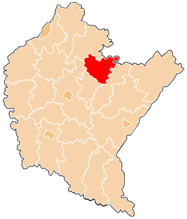
Gmina Leżajsk is a rural gmina in Leżajsk County, Subcarpathian Voivodeship, in south-eastern Poland. Its seat is the town of Leżajsk, although the town is not part of the territory of the gmina.

Gmina Krzeszów is a rural gmina in Nisko County, Subcarpathian Voivodeship, in south-eastern Poland. Its seat is the village of Krzeszów, which lies approximately 21 kilometres (13 mi) south-east of Nisko and 48 km (30 mi) north-east of the regional capital Rzeszów.
Gmina Sokołów Małopolski is an urban-rural gmina in Rzeszów County, Subcarpathian Voivodeship, in south-eastern Poland. Its seat is the town of Sokołów Małopolski, which lies approximately 24 kilometres (15 mi) north of the regional capital Rzeszów.

Gwizdów is a village in the administrative district of Gmina Leżajsk, within Leżajsk County, Subcarpathian Voivodeship, in south-eastern Poland. It lies approximately 11 kilometres (7 mi) south-west of Leżajsk and 30 km (19 mi) north-east of the regional capital Rzeszów.
Hucisko is a village in the administrative district of Gmina Leżajsk, within Leżajsk County, Subcarpathian Voivodeship, in south-eastern Poland. It lies approximately 11 kilometres (7 mi) west of Leżajsk and 33 km (21 mi) north-east of the regional capital Rzeszów.
Przychojec is a village in the administrative district of Gmina Leżajsk, within Leżajsk County, Subcarpathian Voivodeship, in south-eastern Poland. It lies approximately 5 kilometres (3 mi) north-west of Leżajsk and 41 km (25 mi) north-east of the regional capital Rzeszów.

Jelna is a village in the administrative district of Gmina Nowa Sarzyna, within Leżajsk County, Subcarpathian Voivodeship, in south-eastern Poland. It lies approximately 4 kilometres (2 mi) south-east of Nowa Sarzyna, 7 km (4 mi) north-west of Leżajsk, and 39 km (24 mi) north-east of the regional capital Rzeszów.
Jelna-Judaszówka is a village in the administrative district of Gmina Nowa Sarzyna, within Leżajsk County, Subcarpathian Voivodeship, in south-eastern Poland. It lies approximately 3 kilometres (2 mi) south of Nowa Sarzyna, 10 km (6 mi) north-west of Leżajsk, and 38 km (24 mi) north-east of the regional capital Rzeszów.
Łętownia is a village in the administrative district of Gmina Nowa Sarzyna, within Leżajsk County, Subcarpathian Voivodeship, in south-eastern Poland. It lies approximately 7 kilometres (4 mi) west of Nowa Sarzyna, 16 km (10 mi) north-west of Leżajsk, and 37 km (23 mi) north-east of the regional capital Rzeszów.
Łukowa is a village in the administrative district of Gmina Nowa Sarzyna, within Leżajsk County, Subcarpathian Voivodeship, in south-eastern Poland. It lies approximately 4 kilometres (2 mi) east of Nowa Sarzyna, 8 km (5 mi) north-west of Leżajsk, and 42 km (26 mi) north-east of the regional capital Rzeszów.
Ruda Łańcucka is a village in the administrative district of Gmina Nowa Sarzyna, within Leżajsk County, Subcarpathian Voivodeship, in south-eastern Poland. It lies approximately 3 kilometres (2 mi) east of Nowa Sarzyna, 9 km (6 mi) north-west of Leżajsk, and 41 km (25 mi) north-east of the regional capital Rzeszów.
Sarzyna is a village in the administrative district of Gmina Nowa Sarzyna, within Leżajsk County, Subcarpathian Voivodeship, in south-eastern Poland. It lies approximately 4 kilometres (2 mi) north-east of Nowa Sarzyna, 11 km (7 mi) north-west of Leżajsk, and 43 km (27 mi) north-east of the regional capital Rzeszów.
Tarnogóra is a village in the administrative district of Gmina Nowa Sarzyna, within Leżajsk County, Subcarpathian Voivodeship, in south-eastern Poland. It lies approximately 5 kilometres (3 mi) north of Nowa Sarzyna, 14 km (9 mi) north-west of Leżajsk, and 43 km (27 mi) north-east of the regional capital Rzeszów.
Wola Żarczycka is a village in the administrative district of Gmina Nowa Sarzyna, within Leżajsk County, Subcarpathian Voivodeship, in south-eastern Poland. It lies approximately 6 kilometres (4 mi) south-west of Nowa Sarzyna, 14 km (9 mi) west of Leżajsk, and 35 km (22 mi) north-east of the regional capital Rzeszów.
Wólka Łętowska is a village in the administrative district of Gmina Nowa Sarzyna, within Leżajsk County, Subcarpathian Voivodeship, in south-eastern Poland. It lies approximately 9 kilometres (6 mi) west of Nowa Sarzyna, 18 km (11 mi) west of Leżajsk, and 35 km (22 mi) north-east of the regional capital Rzeszów.
Lisewo is a village in the administrative district of Gmina Przechlewo, within Człuchów County, Pomeranian Voivodeship, in northern Poland. It lies approximately 4 kilometres (2 mi) south of Przechlewo, 15 km (9 mi) north-west of Człuchów, and 112 km (70 mi) south-west of the regional capital Gdańsk.