Ethiopia, officially the Federal Democratic Republic of Ethiopia, is a country in the northeastern part of Africa, popularly known as the Horn of Africa. It shares borders with Eritrea to the north, Djibouti to the northeast, and Somalia to the east, Sudan to the northwest, South Sudan to the west, and Kenya to the south. With over 102 million inhabitants, Ethiopia is the most populous landlocked country in the world and the second-most populous nation on the African continent that covers a total area of 1,100,000 square kilometres (420,000 sq mi). Its capital and largest city is Addis Ababa, which lies a few miles west of the East African Rift that splits the country into the Nubian Plate and the Somali Plate.
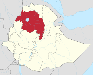
Amhara Region is one of the nine ethnic divisions of Ethiopia, containing the homeland of the Amhara people. Previously known as "Region 3", its capital is Bahir Dar. Ethiopia's largest inland body of water, Lake Tana, which is the source of the Blue Nile river, is located within Amhara. The region also contains the Semien Mountains National Park, which includes Ras Dashan, the highest point in Ethiopia. Amhara is bordered by the state of Sudan to the west and northwest, and in other directions by other regions of Ethiopia: Tigray to the north, Afar to the east, Benishangul-Gumuz to the west and southwest, and Oromia to the south.
Based on figures from the Central Statistical Agency in 2005, Karakore has an estimated total population of 10,859 of whom 5,553 were males and 5,306 were females.[2] The 1994 census reported this town had a total population of 6,247 of whom 2,922 were males and 3,325 were females. It is one of two towns in Antsokiyana Gemzaworeda.
Antsokiyana Gemza is one of the districts of Ethiopias in the Amhara Region of Ethiopia. This district is partly named for one of the districts of Shewa, Antsokia. Part of the North Shewa Zone, Antsokiyana Gemza is bordered on the south by Efratana Gidim, on the southwest by Menz Gera Midir, on the west by Geshe, and on the north and east by the Oromia Zone. The administrative center is Mekoy; other towns in Antsokiyana Gemza include Majete.
Notes
↑ There is also references to another settlement Majete also called "Iruf Kolemo", with a latitude and longitude of 10°27′N39°51′E / 10.450°N 39.850°E / 10.450; 39.850. It is unclear if these are simply different geographical coordinates for the same Majete.
This page is based on this Wikipedia article Text is available under the CC BY-SA 4.0 license; additional terms may apply. Images, videos and audio are available under their respective licenses.
Related Research Articles
Ziway or Zway is a town and separate woreda in central Ethiopia. It is located on the road connecting Addis Ababa to Nairobi in the East Shewa Zone of the Oromia Region of Ethiopia, Ziway has a latitude and longitude of 7°56′N38°43′E with an elevation of 1643 meters above sea level.
Dibate is a town in western Ethiopia, named after a local tribe. Located in the Metekel Zone of Benishangul-Gumuz, Dibate has a latitude and longitude of 10°39′N36°13′E with an elevation of 1438 meters above sea level.
Abomsa is a town in central Ethiopia; Traditionally, the Etymology of the word Abomsa is ʔabbo /Abbo/ and mɨsɑ. Abbo is the short form of the Name Saint Abune Gebre Menfes Kiduss and popularly called Abbo and mɨsa is lunch. In the early period, the people who preceded at that place celebrated a memorial day for the Abune Gebre Menfes Kiduss, and after the lunch, they said we had the lunch in the name of Abbo, then they named the place Abbomɨsa. Located in the Arsi Zone of the Oromia Region, the town has a latitude and longitude of 8°35′N39°51′E and an altitude of 1438 meters. It is the administrative center of Merti woreda.
Welenchiti is a town in east-central Ethiopia. Located in the Misraq (East) Shewa Zone of the Oromia Region, this town has a longitude and latitude of 8°40′N39°26′E and an elevation of 1436 meters above sea level. It is the administrative center of Boset woreda.
Wenji Gefersa is a town in central Ethiopia. Located in the Misraq (East) Shewa Zone of the Oromia Region, it has a latitude and longitude of 8°27′N39°17′E with an elevation of 1588 meters above sea level.
Bedele is a town and separate woreda in south-western Ethiopia. Located in the Buno Bedelle Zone of the Oromia Region, this town has a longitude and latitude of 8°27′N36°21′E and an elevation between 2,012–2,162 metres (6,601–7,093 ft) above sea level.
Mojo is a town in central Ethiopia, named after the nearby Modjo River. Located in the Misraq Shewa Zone of the Oromia Region, it has a latitude and longitude of 8°39′N39°5′E with an elevation between 1788 and 1825 meters above sea level. It is the administrative center of Lome woreda.
Shewa Robit is a town in north-central Ethiopia. Located in the Semien Shewa Zone of the Amhara Region, this town has a longitude and latitude of 10°00′N39°54′E with an elevation of 1280 meters above sea level. Shewa Robit holds its market on Wednesdays.
Goro is a town in central Ethiopia. Located in the Mirab Shewa Zone of the Oromia Region, this town has a latitude and longitude of 8°23′N37°51′E.
Fofa is a town in southern Ethiopia, and is the administrative center of the Yem special woreda. Located in the Southern Nations, Nationalities, and Peoples Region, this town has a latitude and longitude of 07°51′N37°31′E with an elevation of 2506 meters above sea level.
Atsbi is a town in Tigray, Ethiopia. Located in the Misraqawi (Eastern) Zone of the Tigray Region, about 50 kilometers northeast of Qwiha, this town has a latitude and longitude of 13°52′N39°44′E with an elevation of 2630 meters above sea level. It is the administrative center of Atsbi Wenberta woreda.
Sagure is a town in south-eastern Ethiopia. Located in the Arsi Zone of the Oromia Region, this town has a latitude and longitude of 07°45′N39°09′E with an elevation of 2568 meters above sea level. It is the administrative center of Digeluna Tijo, woreda.
Gobesa is a town in southeastern Ethiopia. Located in the Arsi Zone of the Oromia Region, this town has a latitude and longitude of 07°37′N39°30′E with an elevation of 2353 meters above sea level. It is the administrative center of Sherka woreda.
Ogolcho is a town in southeastern Ethiopia. Located in the Arsi Zone of the Oromia Region, it has a latitude and longitude of 08°03′N39°00′E with an elevation of 1687 meters above sea level. It is the administrative center of Ziway Dugda woreda.
Yechila is a town in northern Ethiopia. Located in the Mehakelegnaw Zone of the Tigray Region, this town has a latitude and longitude of 13°17′N39°00′E with an elevation of 1571 meters above sea level. It is located in the Mearey-tabia and is the administrative center of Abergele woreda.
Karakore is a town in north-eastern Ethiopia. Located in the Semien Shewa Zone of the Amhara Region, this town has a latitude and longitude of 10°29′N39°56′E with an elevation of 1696 meters above sea level.
Digelu is a town in central Ethiopia. Located in the Arsi Zone of the Oromia Region to the east of Sagure, it has a latitude and longitude of 7°45′N39°15′E with an elevation of 2,713 meters (8,901 ft). It is one of three settlements in Digeluna Tijo woreda.
Meraro is a town in central Ethiopia. Located in the Arsi Zone of the Oromia Region to the south of Bekoji, it has a latitude and longitude of 7°41′N39°25′E with an elevation of 3,030 meters.
Wegeltena, also known as Wegel Tena, is a town in the north west of Ethiopia. Located in the Debub Wollo Zone of the Amhara Region, this town has a latitude and longitude of 11°35′N39°13′E with an elevation of 2555 meters above sea level.
Sire is a town in south-western Ethiopia. Located in the Arsi Zone of the Oromia Region, this town has a latitude and longitude of 08°17′N39°27′E with an altitude of 1793 meters above sea level. It is administrative center of Sire woreda.