The Makarov Basin is a seafloor basin in the Arctic Ocean, part of the Amerasian Basin. It lies between the Alpha Ridge and the Lomonosov Ridge. [1] [2]
The Makarov Basin is a seafloor basin in the Arctic Ocean, part of the Amerasian Basin. It lies between the Alpha Ridge and the Lomonosov Ridge. [1] [2]

North Atlantic Deep Water (NADW) is a deep water mass formed in the North Atlantic Ocean. Thermohaline circulation of the world's oceans involves the flow of warm surface waters from the southern hemisphere into the North Atlantic. Water flowing northward becomes modified through evaporation and mixing with other water masses, leading to increased salinity. When this water reaches the North Atlantic, it cools and sinks through convection, due to its decreased temperature and increased salinity resulting in increased density. NADW is the outflow of this thick deep layer, which can be detected by its high salinity, high oxygen content, nutrient minima, high 14C/12C, and chlorofluorocarbons (CFCs).

Hudson Bay, sometimes called Hudson's Bay, is a large body of saltwater in northeastern Canada with a surface area of 1,230,000 km2 (470,000 sq mi). It is located north of Ontario, west of Quebec, northeast of Manitoba, and southeast of Nunavut, but politically entirely part of Nunavut. It is an inland marginal sea of the Arctic Ocean. The Hudson Strait provides a connection between the Labrador Sea and the Atlantic Ocean in the northeast, while the Foxe Channel connects Hudson Bay with the Arctic Ocean in the north. The Hudson Bay drainage basin drains a very large area, about 3,861,400 km2 (1,490,900 sq mi), that includes parts of southeastern Nunavut, Alberta, Saskatchewan, Ontario, Quebec, all of Manitoba, and parts of the U.S. states of North Dakota, South Dakota, Minnesota, and Montana. Hudson Bay's southern arm is called James Bay.

The Mid-Atlantic Ridge is a mid-ocean ridge located along the floor of the Atlantic Ocean, and part of the longest mountain range in the world. In the North Atlantic, the ridge separates the North American from the Eurasian plate and the African plate, north and south of the Azores triple junction. In the South Atlantic, it separates the African and South American plates. The ridge extends from a junction with the Gakkel Ridge northeast of Greenland southward to the Bouvet triple junction in the South Atlantic. Although the Mid-Atlantic Ridge is mostly an underwater feature, portions of it have enough elevation to extend above sea level, for example in Iceland. The ridge has an average spreading rate of about 2.5 centimetres (1 in) per year.

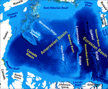
The Gakkel Ridge is a mid-oceanic ridge, a divergent tectonic plate boundary between the North American Plate and the Eurasian Plate. It is located in the Eurasian Basin of the Arctic Ocean, between Greenland and Siberia. Geologically, it connects the northern end of the Mid-Atlantic Ridge with the Laptev Sea Rift.

Arctica, or Arctida is a hypothetical ancient continent which formed approximately 2.565 billion years ago in the Neoarchean era. It was made of Archaean cratons, including the Siberian Craton, with its Anabar/Aldan shields in Siberia, and the Slave, Wyoming, Superior, and North Atlantic cratons in North America. Arctica was named by Rogers 1996 because the Arctic Ocean formed by the separation of the North American and Siberian cratons. Russian geologists writing in English call the continent "Arctida" since it was given that name in 1987, alternatively the Hyperborean craton, in reference to the hyperboreans in Greek mythology.

The Pechora is the sixth-longest river in Europe. Flowing from Northwest Russia and into the Arctic Ocean, it lies mostly in the Komi Republic but the northernmost part crosses the Nenets Autonomous Okrug.

A mid-ocean ridge (MOR) is a seafloor mountain system formed by plate tectonics. It typically has a depth of about 2,600 meters (8,500 ft) and rises about 2,000 meters (6,600 ft) above the deepest portion of an ocean basin. This feature is where seafloor spreading takes place along a divergent plate boundary. The rate of seafloor spreading determines the morphology of the crest of the mid-ocean ridge and its width in an ocean basin.
The Lomonosov Ridge is an unusual underwater ridge of continental crust in the Arctic Ocean. It spans 1,800 kilometres (1,100 mi) between the New Siberian Islands over the central part of the ocean to Ellesmere Island of the Canadian Arctic Archipelago. The ridge divides the Arctic Basin into the Eurasian Basin and the Amerasian Basin. The width of the Lomonosov Ridge varies from 60 to 200 kilometres. It rises 3,300 to 3,700 metres above the 4,200-metre (13,800 ft) deep seabed. The minimum depth of the ocean above the ridge is less than 400 metres (1,300 ft). Slopes of the ridge are relatively steep, broken up by canyons, and covered with layers of silt. It is an aseismic ridge.

Kane Basin is an Arctic waterway lying between Greenland and Ellesmere Island, Canada's northernmost. It links Smith Sound to Kennedy Channel and forms part of Nares Strait. It is approximately 180 km (110 mi) in length and 130 km (81 mi) at its widest.
East Kurrajong is a suburb located in the north-west Sydney basin, in the state of New South Wales, Australia. It is located in the City of Hawkesbury north of Glossodia and east of Kurrajong.
The Alpha Ridge is a major volcanic ridge under the Arctic Ocean between the Canada Basin and the Lomonosov Ridge. It was active during the formation of the Amerasian Basin. It was discovered in 1963. The highest elevation is about 2,700 m over the ocean floor. It is 200 to 450 km wide. The Alpha Ridge, Lomonosov Ridge, and Nansen-Gakkel Ridge are the three major ranges that divide the Arctic Ocean floor, running generally parallel to each other.
The Eurasian Basin, or Eurasia Basin, is one of the two major basins into which the Arctic Basin of the Arctic Ocean is split by the Lomonosov Ridge. The Eurasia Basin may be seen as an extension of the North Atlantic Basin through Fram Strait. It is further split by the mid-ocean Gakkel Ridge into the Nansen Basin and the Amundsen Basin. The latter basin is the deepest one of the Arctic Ocean and the geographic North Pole is located there.
The Amerasia Basin, or Amerasian Basin, is one of the two major basins from which the Arctic Ocean can be subdivided. The triangular-shaped Amerasia Basin broadly extends from the Canadian Arctic Islands to the East Siberian Sea, and from Alaska to the Lomonosov Ridge. The basin can be further subdivided based on bathymetric features; these include the Canada Basin, the Makarov Basin, the Podvodnikov Basin, the Alpha-Mendeleev Ridge, and the Chukchi Plateau.
The High Arctic Large Igneous Province (HALIP) is a Cretaceous large igneous province in the Arctic. The region is divided into several smaller magmatic provinces. Svalbard, Franz Josef Land, Sverdrup Basin, Amerasian Basin, and northern Greenland are some of the larger divisions. Today, HALIP covers an area greater than 1,000,000 km2 (390,000 sq mi), making it one of the largest and most intense magmatic complexes on the planet. However, eroded volcanic sediments in sedimentary strata in Svalbard and Franz Josef Land suggest that an extremely large portion of HALIP volcanics have already been eroded away.
The Molloy Deep is a bathymetric feature in the Fram Strait, within the Greenland Sea east of Greenland and about 160 km (100 mi) west of Svalbard. It is the location of the deepest point in the Arctic Ocean. The Molloy Deep, Molloy Hole, Molloy Fracture Zone, and Molloy Ridge were named after Arthur E. Molloy, a U.S. Navy research scientist who worked in the North Atlantic, North Pacific, and Arctic Oceans in the 1950s–1970s.
The Arctic Basin is an oceanic basin in the Arctic Ocean, consisting of two main parts separated by the Lomonosov Ridge, a mid-ocean ridge between north Greenland and the New Siberian Islands. It is bordered by the continental shelves of Eurasia and North America.

The Arctic Ocean is the smallest and shallowest of the world's five oceanic divisions. It spans an area of approximately 14,060,000 km2 (5,430,000 sq mi) and is the coldest of the world's oceans. The International Hydrographic Organization (IHO) recognizes it as an ocean, although some oceanographers call it the Arctic Mediterranean Sea. It has also been described as an estuary of the Atlantic Ocean. It is also seen as the northernmost part of the all-encompassing world ocean.

The Amundsen Basin, with depths up to 4.4 km (2.7 mi), is the deepest abyssal plain in the Arctic Ocean, and contains the geographic North Pole. The Amundsen Basin is embraced by the Lomonosov Ridge and the Gakkel Ridge. It is named after the polar researcher Roald Amundsen. Together with the Nansen Basin, the Amundsen Basin is often summarized as Eurasian Basin.
The Nansen Basin is an abyssal plain with water-depths of around 3 km in the Arctic Ocean and part of the Eurasian Basin. It is named after Fridtjof Nansen. The Nansen Basin is bounded by the Gakkel Ridge on the one side and by the Barents Sea continental shelf on the other.
The Mid-Labrador Ridge was a mid-ocean ridge in the Labrador Sea that represented a divergent boundary between the Greenland and North American plates during the Paleogene. The ridge extended from the South Greenland Triple Junction in the southeast to the Davis Strait area in the northwest. Seafloor spreading along the Mid-Labrador Ridge discontinued about 40 million years ago when the mid-ocean ridge became essentially extinct.
| | This article about a specific oceanic location or ocean current is a stub. You can help Wikipedia by expanding it. |
| | This Arctic-related article is a stub. You can help Wikipedia by expanding it. |