Related Research Articles

Crete is the largest and most populous of the Greek islands, the 88th largest island in the world and the fifth largest island in the Mediterranean Sea, after Sicily, Sardinia, Cyprus, and Corsica. Crete rests about 160 km (99 mi) south of the Greek mainland, and about 100 km (62 mi) southwest of Anatolia. Crete has an area of 8,450 km2 (3,260 sq mi) and a coastline of 1,046 km (650 mi). It bounds the southern border of the Aegean Sea, with the Sea of Crete to the north and the Libyan Sea to the south. Crete covers 260 km from west to east but is narrow from north to south, spanning three longitudes but only half a latitude.

Chania, also spelled Hania, is a city in Greece and the capital of the Chania regional unit. It lies along the north west coast of the island Crete, about 70 km (43 mi) west of Rethymno and 145 km (90 mi) west of Heraklion.
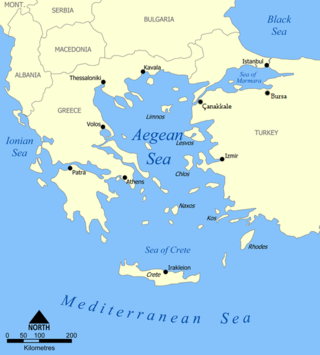
The Sea of Crete, or Cretan Sea, is a sea, part of the Aegean Sea, located in its southern extremity, with a total surface area of 45,000 km2 (17,000 sq mi). The sea stretches to the north of the island of Crete, east of the islands of Kythera and Antikythera, south of the Cyclades, and west of the Dodecanese islands of Rhodes, Karpathos and Kassos. The bounding sea to the west is the Ionian Sea. To the northwest is the Myrtoan Sea, a subdivision of the Mediterranean Sea that lies between the Cyclades and Peloponnese. To the east-southeast is the rest of the Mediterranean Sea, sometimes credited as the Levantine Sea. Across the island of Crete, to the opposite shore of it begins the Libyan Sea. Ferry routes to and from Piraeus and Heraklion, as well as the southern islands of the Aegean and the Dodecanese, run in this area.

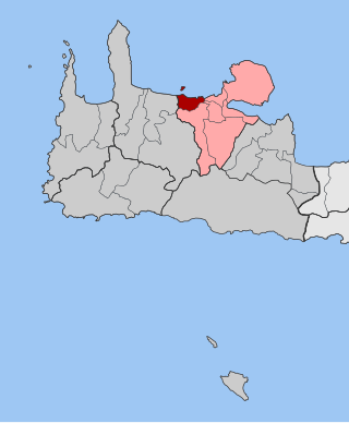
Akrotiri is a peninsula and former municipality in the Chania regional unit, Crete, Greece. Since the 2011 local government reform it is part of the municipality Chania, of which it is a municipal unit. The municipal unit has an area of 112.644 km2 (43.492 sq mi). Its ancient name was Kiamon while the Byzantines called it Charaka. The largest town in the peninsula is Kounoupidiana. The beach at Stavros became famous because of the film Zorba the Greek.

Apokoronas is a municipality and a former province (επαρχία) in the Chania regional unit, north-west Crete, Greece. It is situated on the north coast of Crete, to the east of Chania itself. The seat of the municipality is the village Vryses. The municipality has an area of 315.478 km2 (121.807 sq mi).

Chania, also spelled Hania, is one of the four regional units of Crete; it covers the westernmost quarter of the island. Its capital is the city of Chania. Chania borders only one other regional unit: that of Rethymno to the east. The western part of Crete is bounded to the north by the Cretan Sea(part of the Aegean Sea) and to the west and south by the Mediterranean Sea and Libyan Sea. The regional unit also includes the southernmost island of Europe, Gavdos.

Kydonia or Cydonia was an ancient city-state on the northwest coast of the island of Crete. It is at the site of the modern-day Greek city of Chania. In legend Cydonia was founded by King Cydon (Κύδων), a son of Hermes or Apollo and of Akakallis, the daughter of King Minos. According to Pausanias he was son of king Tegeates.

Souda Bay is a bay and natural harbour near the town of Souda on the northwest coast of the Greek island of Crete. The bay is about 15 km long and only two to four km wide, and a deep natural harbour. It is formed between the Akrotiri peninsula and Cape Drapano, and runs west to east. The bay is overlooked on both sides by hills, with a relatively low and narrow isthmus in the west near Chania.
Nea Kydonia is a former municipality in the Chania regional unit, Crete, Greece. Since the 2011 local government reform it is part of the municipality Chania, of which it is a municipal unit. The municipal unit has an area of 21.457 km2 (8.285 sq mi). It is situated on the western outskirts of Chania. It saw fierce fighting during the Battle of Crete during World War II and there the main prisoner of war camp for Allied soldiers in Western Crete was in Galatas.

Keramia is a former municipality in the Chania regional unit, Crete, Greece. Since the 2011 local government reform it is part of the municipality Chania, of which it is a municipal unit. The municipal unit has an area of 89.722 km2 (34.642 sq mi). It is part of the former Kydonia Province.
The Gulf of Chania is an embayment of the Sea of Crete in the northwestern region of the island of Crete in present-day Greece. One headland forming the Gulf of Chania is the promontory known as the Akrotiri Peninsula.

Elyrus or Elyros was a town of ancient Crete, which the Periplus of Pseudo-Scylax places between Cydonia and Lissus. It had a harbour, Syia (Συΐα), situated on the south coast of the island, 60 stadia west of Poecilassus. Pausanias states that the city existed in his time in the mountains of Crete. He adds that he had seen at Delphi the bronze goat which the Elyrians had dedicated, and which was represented in the act of giving suckle to Phylacis and Phylander, children of Apollo and the nymph Acacallis, whose love had been won by the youthful god at the house of Casmanor at Tarrha. It was the birthplace of Thaletas, who was considered as the inventor of the Cretic rhythm, the national paeans and songs, with many of the institutions of his country. Elyrus appears in Hierocles' list of Cretan cities, then reduced in number to twenty-one. The coins of this city have the type of a bee upon them.

Aptera or Apteron was an ancient city, now an archaeological site in western Crete, a kilometre inland from the southern shore of Souda Bay, about 13 km east of the city of Chania in the municipality of Chania.
Mount Tityros is a hill landform in western Crete in the vicinity of the modern-day city of Chania, Greece. In ancient times Mount Tityros was associated with the early Cretan city of Kydonia. Residents of the ancient city of Kydonia dedicated a temple to the goddess Britomartis on Mount Tityros.
Malaxa is a village in the Chania regional unit on Crete in Greece. The 2011 census counted a population of 115 people in the village. In ancient times the Malaxa area was under the sphere of influence of the nearby powerful city of Kydonia. Malaxa lies on the feet of the Lefka Ori, and is separated from the large city of Chania by the Chania Plain.
The Chania Plain is a relatively level landform spreading southward from the city of Chania on the island of Crete in the present day country of Greece. The Chania Plain has been used as a logical study area for air pollution transport in the vicinity of Chania. In ancient times the city of Kydonia, the site of present-day Chania, controlled an expansive area which included the Chania Plain lying to its south at least to Malaxa Mountain.
Kastelli Hill is a landform at the city of Chania on the island of Crete in the present day country of Greece. The Minoan city of ancient Cydonia was centered on Kastelli Hill, which later was selected by the Romans as the site of an acropolis.
Malaxa may refer to:

The Cretan Revolt of 1897–1898 was a successful insurrection by the Greek population of Crete against the rule of the Ottoman Empire after decades of rising tensions. The Greek insurrectionists received supplies and armed support first from the Kingdom of Greece; then later from the Great Powers: the United Kingdom, France, Italy, Austria-Hungary, Germany and Russia. The conflict ended in 1898 with Cretan-allied victory and Ottoman retreat when the Great Powers cut their funding and proposed a resolution which stipulated:
- The Island of Crete become an autonomous state under the nominal sovereignty of the Ottoman Empire, with the Prince George of Greece as governor.
- The Ottoman Empire recognize the sovereignty of the Kingdom of Greece.
- The Kingdom of Greece recognize the sovereignty of the Ottoman Empire.
References
- H. Closs, Dietrich Hans Roeder, Klaus Schmidt (1978). Alps, Apennines, Hellenides: Geodynamic Investigation Along Geotraverses, Schweizerbart, 620 pp., ISBN 3-510-65083-2.
- C. Michael Hogan, Cydonia, The Modern Antiquarian, Jan. 23, 2008
| Authority control databases: Geographic |
|---|
| | This Crete location article is a stub. You can help Wikipedia by expanding it. |