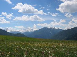
Mals Heath

Last updated
Mals Heath Malser haide.jpg
Mals Heath

The Mals Heath [1] [2] (German : Malser Haide) in South Tyrol, Italy, is one of the largest ancient landslides and one of the most remarkable landscape features in the Alps. It is located in the Upper Vinschgau where a broad pass (the Reschen Pass) crosses the main Alpine divide into the Inn Valley (Austria). It extends from Glurns via Laatsch, Schleis, and Burgeis up to Plawenn. On the southern part is the village of Mals. The height difference of the heath varies from 900 m (Glurns) to 1,760 m (Plawenner Alm). The landslide emerges from the small side valley of Plawenntal, and descends for 11 km to the head of Vinschgau proper. The volume of the debris fan is estimated at 1,650 million cubic metres. It had always been assumed to be an alluvial fan, built up by numerous floods and debris small flows. New research demonstrates that a lost mountain could have existed above the head of Plawenntal, with a summit at about 3,100m - the present highest peak on the perimeter being the Mittereck, 2,908 m. There are indications all around the perimeter of a catastrophic collapse, severing former ridges and valley heads (notably Vivanatal). The shape of the lost mountain can readily be reconstructed by projecting these truncated landforms until they meet up. The volume of the lost mountain (named Plawennspitz) is very close to that of Mals Heath. There is at present no evidence of when this event occurred, but probably soon after the last glacier melted, over 10,000 years ago. Similar events probably created large fans nearby at St. Valentin, and in the main Vinschgau, notably at Allitz-Laas (Gadriamure) where the lost mountain and vast debris cone are even larger. Other megafans in the Alps are likely to be catastrophic too (1). [3] The Mals Heath used to be a barren heath since it was so free draining. The debris fan dams a lake, Haidersee, which is now used as a source of irrigation water through a system of channels, and nearly all the heath is now cultivated and prosperous. The fan also displaces the main river, Adige, and the large tributary, Puni, to opposite sides of the valley. Disastrous floods still occur, destroying houses and even villages. The main road climbs the fan in broad zigzags, not the usual hairpins of an alpine pass, with several large wind turbines taking advantage of the smooth terrain and natural wind funnel.

German language West Germanic language

German is a West Germanic language that is mainly spoken in Central Europe. It is the most widely spoken and official or co-official language in Germany, Austria, Switzerland, South Tyrol (Italy), the German-speaking Community of Belgium, and Liechtenstein. It is also one of the three official languages of Luxembourg and a co-official language in the Opole Voivodeship in Poland. The languages which are most similar to German are the other members of the West Germanic language branch: Afrikaans, Dutch, English, the Frisian languages, Low German/Low Saxon, Luxembourgish, and Yiddish. There are also strong similarities in vocabulary with Danish, Norwegian and Swedish, although those belong to the North Germanic group. German is the second most widely spoken Germanic language, after English.

South Tyrol Autonomous province of Italy

South Tyrol is an autonomous province in northern Italy. It is one of the two autonomous provinces that make up the autonomous region of Trentino-Alto Adige/Südtirol. Its official trilingual denomination is Autonome Provinz Bozen – Südtirol in German, Provincia autonoma di Bolzano – Alto Adige in Italian and Provinzia autonoma de Bulsan – Südtirol in Ladin, reflecting the three main language groups to which its population belongs. The province is the northernmost of Italy, the second largest, with an area of 7,400 square kilometres (2,857 sq mi) and has a total population of 530,009 inhabitants as of 2018. Its capital and largest city is Bolzano.

Italy republic in Southern Europe

Italy, officially the Italian Republic, is a country in Southern Europe. Located in the middle of the Mediterranean Sea, Italy shares open land borders with France, Switzerland, Austria, Slovenia and the enclaved microstates San Marino and Vatican City. Italy covers an area of 301,340 km2 (116,350 sq mi) and has a largely temperate seasonal and Mediterranean climate. With around 61 million inhabitants, it is the fourth-most populous EU member state and the most populous country in Southern Europe.

Related Research Articles

Landslide type of natural disaster, geological phenomenon

The term landslide or, less frequently, landslip, refers to several forms of mass wasting that include a wide range of ground movements, such as rockfalls, deep-seated slope failures, mudflows and debris flows. Landslides occur in a variety of environments, characterized by either steep or gentle slope gradients: from mountain ranges to coastal cliffs or even underwater, in which case they are called submarine landslides. Gravity is the primary driving force for a landslide to occur, but there are other factors affecting slope stability which produce specific conditions that make a slope prone to failure. In many cases, the landslide is triggered by a specific event, although this is not always identifiable.

Swiss Alps portion of the Alps mountain range that lies within Switzerland

The Alpine region of Switzerland, conventionally referred to as the Swiss Alps, represents a major natural feature of the country and is, along with the Swiss Plateau and the Swiss portion of the Jura Mountains, one of its three main physiographic regions. The Swiss Alps extend over both the Western Alps and the Eastern Alps, encompassing an area sometimes called Central Alps. While the northern ranges from the Bernese Alps to the Appenzell Alps are entirely in Switzerland, the southern ranges from the Mont Blanc massif to the Bernina massif are shared with other countries such as France, Italy, Austria and Liechtenstein.

Geography of Austria

Austria is a small, predominantly mountainous country in Central Europe, approximately between Germany, Italy and Hungary. It has a total area of 83,879 km² (32,385 mi²), about twice the size of Switzerland.

Alluvial fan A fan- or cone-shaped deposit of sediment crossed and built up by streams

Alluvial fans are triangular-shaped deposits of water-transported material, often referred to as alluvium. They are an example of an unconsolidated sedimentary deposit and tend to be larger and more prominent in arid to semi-arid regions. These alluvial fans typically form in elevated or even mountainous regions where there is a rapid change in slope from a high to low gradient. The river or stream carrying the sediment flows at a relatively high velocity due to the high slope angle which is why coarse material is able to remain in the flow. When the slope decreases rapidly into a relatively plain or plateau, the stream loses the energy it needs to move its sediment. Deposition subsequently occurs and the sediment ultimately spreads out, creating an alluvial fan. Three primary zones occur within an alluvial fan which includes the proximal fan, medial fan, and the distal fan.

Adige river in Northern Italy

The Adige is the second longest river in Italy after the Po, rising in the Alps in the province of South Tyrol near the Italian border with Austria and Switzerland, flowing 410 kilometres (250 mi) through most of North-East Italy to the Adriatic Sea.

Central Eastern Alps central-eastern parts of the Alps mountain range

The Central Eastern Alps, also referred to as Austrian Central Alps or just Central Alps comprise the main chain of the Eastern Alps in Austria and the adjacent regions of Switzerland, Liechtenstein, Italy and Slovenia.

Ortler Alps mountain range

The Ortler Alps are a mountain range of the Southern Limestone Alps mountain group in the Central Eastern Alps, in Italy and Switzerland.

Tanaro river in northwestern Italy

The Tanaro, known as Tanarus in ancient times and Tane or Tani in piedmontese language, is a 276-kilometre (171 mi) long river in northwestern Italy. The river begins in the Ligurian Alps, near the border with France, and is the most significant right-side tributary to the Po in terms of length, size of drainage basin, and discharge.

Geography of the Alps

The Alps cover a large area. This article describes the delimitation of the Alps as a whole and of subdivisions of the range, follows the course of the main chain of the Alps and discusses the lakes and glaciers found in the region.

Vinschgau District in Italy

The Vinschgau or Vinschgau Valley is the upper part of the Adige or Etsch river valley, in the western part of the province of South Tyrol, Italy.

Laas, South Tyrol Comune in Trentino-Alto Adige/Südtirol, Italy

Laas is a comune (municipality) in the province of South Tyrol in northern Italy, located about 50 kilometres (31 mi) west of the city of Bolzano.

Battle of Calven event

The Battle of Calven took place on May 22, 1499 at the exit of the Val Müstair in the Grisons to the Vinschgau in County of Tyrol between the forces of king Maximilian I of the House of Habsburg and those of the free federation of the Three Leagues of the Grisons. It was the decisive battle in the southern Grisons of the Swabian War; after the defeat of the Habsburg troops, the king had to abandon his attempts to control the Engadin and the Val Müstair. The focus of operations in the Swabian War subsequently shifted again to the northern border of the Old Swiss Confederacy.

Alpine Brigade Orobica

The Alpine Brigade Orobica was a light Infantry brigade of the Italian Army, specializing in mountain warfare. Its core units were the Alpini, the mountain infantry corps of the Italian Army, that distinguished itself in combat during World War I and World War II.

Nauders Place in Tyrol, Austria

Nauders is a municipality in the district of Landeck in the Austrian state of Tyrol.

Val Pola landslide

The Val Pola landslide happened in Valtellina, Lombardy, Northern Italian Alps, on July 28, 1987 and resulted in the Valtellina disaster with the total cost of 400 million euros. The calamity affected the provinces of Sondrio, Brescia, Bergamo, Lecco, and Como.

Ammergau Alps mountain range

The Ammergau Alps are a mountain range in the Northern Limestone Alps in the states of Bavaria (Germany) and Tyrol (Austria). They cover an area of about 30 x 30 km and begin at the outer edge of the Alps. The highest summit is the Daniel which has a height of 2,340 metres (7,680 ft).

Venediger Group mountain range

The Venediger Group is a mountain range of the Central Eastern Alps. Together with the Granatspitze Group, the Glockner Group, the Goldberg Group, and the Ankogel Group, it forms the main ridge of the High Tauern. The highest peak is the Großvenediger at 3,657 m (AA), which gives its name to the group. Considerable parts of the Venediger Group belong to the core zone of the High Tauern National Park.

Burgeis human settlement in Italy

Burgeis is the largest frazione of the comune of Mals, Italy, and sits at an altitude of 1216m in Vinschgau in South Tyrol beneath the mountain Watles (2557) on the upper reaches of the Adige. The name goes all the way back to a Roman founding, as a fort on the "Via Claudia Augusta", which runs through the village. This fort later gave the name of the Edelfreien von Burgus-Wanga, whose arms the village bears today.

St. Valentin auf der Haide frazione of Italy

St. Valentin auf der Haide is a village in South Tyrol in the parish of Graun im Vinschgau. The village on the Reschen Pass lies at a height of 1,472 metres between the Haidersee and Reschensee on the scree slope of the Mals Heath. St. Valentin auf der Haide has about 800 inhabitants who predominantly earn a living from summer and winter tourism.

Mieming Range mountain range

The Mieming(er) Range, Mieminger Chain or Mieminger Mountains, is a mountain range of the Northern Limestone Alps in the Eastern Alps. It is located entirely in Austria within the state of Tyrol. This sub-group is somewhat in the shadows of its more famous neighbour, the Wetterstein to the north. Whilst the region around the Coburger Hut and the lakes of Seebensee and Drachensee in the west and the Hohe Munde in the extreme east receive large numbers of visitors, the less developed central area remains very quiet. The Hohe Munde is also a popular and challenging ski touring destination.

References

  1. Planta, Joseph (1807). The History of the Helvetic Confederacy, Volume 2, 2nd ed., John Stockdale, London. p. 282.
  2. Loose, Rainer (1976). Siedlungsgenese des oberen Vintschgaus: Schichten und Elemente des Theresianischen Siedlungsgefüges einer südtiroler Passregion, Zentralausschuss für deutsche Landeskunde, Indiana University, p. 233. ISBN   978-3-8814-3001-2.
  3. Jarman D, Agliardi F, Crosta G (2011): Megafans and outsize fans from catastrophic slope failures in alpine glacial troughs: the Malser Haide and the Val Venosta cluster, Italy. Geological Society Special Publication 351, pp 253-278

Coordinates: 46°43′10″N10°32′39″E / 46.71944°N 10.54417°E / 46.71944; 10.54417

Geographic coordinate system Coordinate system

A geographic coordinate system is a coordinate system that enables every location on Earth to be specified by a set of numbers, letters or symbols. The coordinates are often chosen such that one of the numbers represents a vertical position and two or three of the numbers represent a horizontal position; alternatively, a geographic position may be expressed in a combined three-dimensional Cartesian vector. A common choice of coordinates is latitude, longitude and elevation. To specify a location on a plane requires a map projection.