Related Research Articles

Samaria is the Hellenized form of the Hebrew name Shomron, used as a historical and biblical name for the central region of Israel, bordered by Judea to the south and Galilee to the north. The region is known to the Palestinians in Arabic under two names, Samirah, and Mount Nablus.

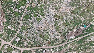
El-Ahwat is an archaeological site in the Manasseh Hills, Israel. It located 10 miles east of Caesarea near Katzir.

The Samaria Ostraca are 102 ostraca found in 1910 in excavations in ancient Samaria led by George Andrew Reisner of the Harvard Semitic Museum. These ostraca were found in the treasury of the palace of Ahab, king of Israel, and probably date about his period, 850–750 BC. Authored by royal scribes, the ostraca primarily record food deliveries, serving an archival function.
Tell el-Hammeh is a medium-size archaeological tell in the West Bank, at the southern fringe of the Beit She'an valley. It has been identified with the Canaanite city state of Hammath, mentioned in a late-13th century BCE Egyptian inscription.
'Ara is a village in the Haifa District in northern Israel, located in the Wadi Ara valley. Since 1985, 'Ara has been part of the Ar'ara local council. It is located north of highway 65, between Ar'ara and Kfar Qara. Its population of 4,600 is almost entirely Muslim.
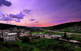
Wadi Ara or Nahal 'Iron, is a valley and its surrounding area in Israel populated mainly by Arab Israelis. The area is also known as the "Northern Triangle".

Sebastia is a Palestinian village of about 3,205 inhabitants, located in the Nablus Governorate of the State of Palestine, some 12 kilometers northwest of the city of Nablus.

Yasid is a Palestinian town in the Nablus Governorate in northern West Bank, located 15 kilometers northeast of Nablus. According to the Palestinian Central Bureau of Statistics (PCBS), the town had a population of 2,291 inhabitants in mid-year 2006 and 2,505 by 2017.

Rummanah is a Palestinian village located 17 kilometers (11 mi) northwest of the city of Jenin in the northern West Bank. According to the Palestinian Central Bureau of Statistics (PCBS), the town had a population of 3,372 inhabitants in mid-year 2006.
At-Tayba is a Palestinian village in the West Bank, located 18 km northwest of the city of Jenin in the northern West Bank, and 2 km east of Umm el-Fahm in Israel. According to the Palestinian Central Bureau of Statistics, the town had a population of 2,386 inhabitants in mid-year 2006 and 2,215 in 2017.
The Manasseh Hills or hill country of Manasseh, directly derived from Hebrew: Menashe Heights, called Bilad ar-Ruha in Arabic, meaning "Land of Winds", is a geographical region in northern Israel, located on the Carmel Range, between Mount Carmel and Mount Amir/Umm al-Fahm.

Adam Zertal was an Israeli archaeologist and a tenured professor at the University of Haifa.
Ein as-Sahla is an Arab village in Haifa District, Israel. The village is located in the Wadi Ara area of the northern Triangle. The village has about 2,000 residents. Since 1996, it has been under the jurisdiction of the Basma local council. The vast majority of the residents in Ein as-Sahla adhere to Islam.

Marj Sanur (Arabic: مرج صانور, translation: "Sanur Valley"; also called Marj al-Ghuruq, translation: "Drowning Valley" is a closed basin within the northern mountains of the West Bank, located entirely in the southern Jenin Governorate, in between the cities of Jenin and Nablus.
Zalafa is an Arab village in Israel's Haifa District. The village is in the Wadi Ara area of the northern Triangle, 4 kilometres (2.5 mi) northeast of Umm al-Fahm. Since 1996, it has been under the jurisdiction of the Ma'ale Iron local council whose headquarters is in the village. The village is divided into three neighborhoods: East, West and al-Murtafi'a. In mid-2016, Zalafa's population was 4,639, all of whom are Muslim.
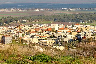
Salem or Salim is an Arab village in Israel's Haifa District. The village is in the Wadi Ara area of the northern Triangle, 4 kilometers northeast of Umm al-Fahm. Since 1996, it has been under the jurisdiction of the Ma'ale Iron local council. In mid-2016 Salem's population was 1,699, predominantly Muslims. The village is divided into five neighborhoods: Abu Bakr, Darwish, Subaihat, Ayash and Rifai. Most of the adult males in the village work in manual labour.

Khirbet el-Mastarah is an archaeological site that includes the largest of the complex oval compound type habitation sites located in the middle Jordan Valley in the West Bank.

The Iron Age I Structure on Mt. Ebal, also known as the Mount Ebal site, Mount Ebal's Altar, and Joshua's Altar, is an archeological site dated to the Iron Age I, located on Mount Ebal, West Bank.
Khirbet Tana et-Tahta is an archeological site located in the West Bank. It lies near the Israeli settlement of Mekhora.
Khirbet Kheibar or Tell Kheibar is an archaeological site located in the western outskirts of the Sanur Valley, West Bank. A fortified tell, it includes the remains of an ancient walled city that for some periods grew beyond the walls. At the site, pottery from the Middle Bronze Age and the Medieval period, peaking in the Iron Age, has been found, along with bowls and figurine fragments.
References
- ↑ The Survey of Manasseh and the Origin of the Central Hill Country Settlers
- ↑ The Manasseh Hill Country Survey Volume 6
- ↑ The Survey of Manasseh and the Origin of the Central Hill Country Settlers
- ↑ "The Iron Age I Structure on Mt. Ebal: Excavation and Interpretation By Ralph K. Hawkins". www.eisenbrauns.org. Retrieved 2022-04-30.
- ↑ Ahwat Homepage
- ↑ The Manasseh Hill Country Survey Volume 2
- ↑ The Manasseh Hill Country Survey, Volume I: The Shechem Syncline
- ↑ The Manasseh Hill Country Survey, Volume 2
- ↑ The Manasseh Hill Country Survey Volume 3: From Nahal ‘Iron to Nahal Shechem
- ↑ The Manasseh Hill Country Survey Volume 4
- ↑ The Manasseh Hill Country Survey Volume 5
- ↑ The Manasseh Hill Country Survey Volume 6
- ↑ The Manasseh Hill Country Survey Volume 7