
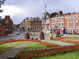
Maney is an area of Sutton Coldfield, Birmingham, England. It is situated close to the town centre of Sutton Coldfield and is also near Wylde Green and Walmley. The main thoroughfare is Birmingham Road, which runs through Maney.
Maney is an area of Sutton Coldfield, Birmingham, England. It is situated close to the town centre of Sutton Coldfield and is also near Wylde Green and Walmley. The main thoroughfare is Birmingham Road, which runs through Maney.
Sutton Coldfield's only remaining cinema is located in Maney. It was operated by Odeon Cinemas from 1936 until 2006, when it was acquired by Empire Cinemas. It was officially opened on April 18, 1936, by Councillor W. A. Perry, the Mayor of Sutton Coldfield. Upon its opening, it had a seating capacity of 1,636 and was designed by Harry Weedon. It was put in direct competition of the 'Empress Cinema' on the Parade in Sutton Coldfield town centre which had reopened after reconstruction work in February of that year. The 'Empress Cinema' shut down in the 1970s and the site is now the location of Sutton Coldfield Library.
Beeches Walk, Birmingham Road, offers a range of shops and restaurants. This parade stands on the site of a large Victorian house 'The Beeches'. In 1929, over 6 acres (24,000 m2) of paddock at the rear of the house was acquired by Compulsory Purchase Order for the building of Sutton Coldfield Grammar School for Girls. In 1932, the old house was demolished and despite some local opposition retail development was permitted.
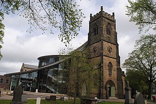
St Peter's Church is located on Maney Hill Road. The foundation stone was laid on June 22, 1904, by Rt. Hon. William Henry Lord Leigh and was completed in 1905. It is the parish church for the parish of St Peter.
Nearby are the local football team, Sutton Coldfield Town F.C., Maney Hill Primary School, Plantsbrook School, and the Sutton Coldfield campus of Birmingham Metropolitan College.
14th century references to this ancient hamlet appear in the National Archives. A windmill was present in the area during the time of Bishop Vesey as a result of the high elevation of Maney Hill in comparison to the other lower lying areas of Sutton.
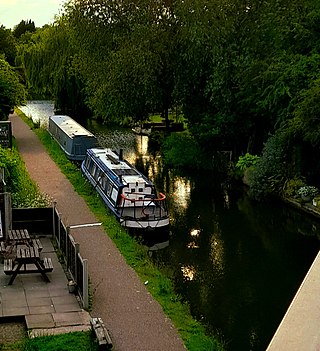
The area contains several buildings of some antiquity having Grade II listed status. These include:
In World War II, a bomb exploded in the middle of Maney Hill Road. The Beatles played a concert on the 1 February 1963 in St Peter's Church Hall.
In the 1921, Maney Corner in Maney became the first place in the world where a centre white line was painted in a road. This was as a result of reckless driving and numerous collisions on the road.[ citation needed ]
Sutton Coldfield or the Royal Town of Sutton Coldfield ( ), is a town and civil parish in the city of Birmingham, West Midlands, England. The town lies around 8 miles northeast of Birmingham city centre, 9 miles south of Lichfield, 7 miles southwest of Tamworth, and 7 miles east of Walsall.

Sutton Park is a large urban park located in Sutton Coldfield, Birmingham, West Midlands, England. Most of the park is a national nature reserve; large parts are also a scheduled monument. Sutton Park is one of the largest urban parks in the United Kingdom. The park covers more than 2,400 acres (970 ha) according to one source, or 2,200 acres (900 ha) according to another. It consists of a mix of heathland, wetlands and marshes, seven lakes, extensive ancient woodlands, several restaurants, a private 18-hole golf course on its western edge and a municipal golf course to the south, a donkey sanctuary, children's playgrounds and a visitors' centre. There is no entrance charge to the Park, however there is a parking charge for cars on Saturdays and Sundays during the summer. A wide range of leisure activities are undertaken in the park including dog walking, pony trekking, bike riding and kite flying and there are areas to fly model aeroplanes and helicopters. Additionally, a railway line runs through the park.
Erdington is a suburb and ward of Birmingham in the West Midlands County, England. Historically part of Warwickshire, it is located 5 miles (8 km) northeast of central Birmingham, bordering Sutton Coldfield. It was also a council constituency, managed by its own district committee. The former council district consisted of the ward of Erdington as well as Tyburn, Stockland Green and Kingstanding, although all of Kingstanding and most of both Tyburn and Stockland Green wards lie outside the historical boundaries of Erdington. Stockland Green was formerly part of Aston, Kingstanding part of Perry Barr, and Tyburn partially split between Aston and Hodge Hill. Erdington (ward) was part of the Sutton Coldfield constituency before 1974.

Sutton Trinity is one of the 40 electoral wards in Birmingham, England. It is named after Holy Trinity Church, the town's parish church.

Wylde Green is a residential area within the town of Sutton Coldfield in Birmingham, England in the West Midlands. It was in the county of Warwickshire. The area is in the Sutton Vesey ward.

Boldmere is a suburb and residential area of Sutton Coldfield, City of Birmingham, England. It is bordered by New Oscott, Sutton Park, Wylde Green and Erdington, and is in the ward of Sutton Vesey.
Coleshill is a market town and civil parish in the North Warwickshire district of Warwickshire, England, taking its name from the River Cole, on which it stands. It had a population of 6,900 in the 2021 Census, and is situated 10 miles (16 km) east-northeast of Birmingham, 9 miles (14 km) southeast of Sutton Coldfield, 11 miles (18 km) south of Tamworth, 13 miles (21 km) northwest of Coventry by road and 13 miles (21km) west of Nuneaton. It is also home to a 502 year old school, being The Coleshill School seated next to the dual carriageway.

Walmley is a suburban village situated in the civil parish of Sutton Coldfield, West Midlands. It lies within the City of Birmingham on its northeastern outer fringe, where it forms part of the Sutton Walmley and Minworth electoral ward. It is in southern Sutton Coldfield, close to Minworth, Erdington, Wylde Green, Pype Hayes and south of Thimble End. It is approximately 7 miles (11.3 km) northeast of Birmingham City Centre. It is the main focus of the Sutton New Hall Birmingham City Council ward.

Water Orton is a village and civil parish in the North Warwickshire borough of Warwickshire in the West Midlands, England near the River Tame. It is located between Castle Bromwich and Coleshill, and borders the West Midlands metropolitan county boundary to the north, west and south. At the 2001 Census, the population was 3,573, falling to 3,444 at the 2011 Census. In the 2021 Census the population slightly rose to 3,487.

John Vesey or Veysey was Bishop of Exeter from 1519 until his death in 1554, having been briefly deposed 1551–3 by King Edward VI for his opposition to the Reformation.

Wiggins Hill is a hamlet situated in the Minworth area of the civil parish of Sutton Coldfield, West Midlands. It lies within the City of Birmingham on its northeastern outer fringe, where it forms part of the Sutton Walmley and Minworth electoral ward and borders the North Warwickshire district.
Falcon Lodge is the area of Sutton Coldfield, Birmingham, West Midlands, England, covered in predominantly council houses forming the Falcon Lodge Estate. It is located between Whitehouse Common and Reddicap Heath. To the west of the estate lies Rectory Park. It forms part of the edge of the Sutton Coldfield conurbation and the English countryside.

Bishop Vesey's Grammar School (BVGS) is a selective state grammar school with academy status in Sutton Coldfield, West Midlands, England. Founded in 1527, it is one of the oldest schools in Britain, the oldest state school in the West Midlands and the third oldest school in the West Midlands after two independent schools, Bablake School and Wolverhampton Grammar School. The school had boarders until 1969 but is now a day school only.

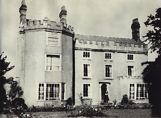
The Moor Hall is a 1905 house, built for Colonel Edward Ansell of Ansells Brewery, in Sutton Coldfield, Birmingham, England. It has been used as a hotel since 1930 and subsequently extended. It is on the site of a former 15th century building. It gives its name to a suburb of the town, situated between the district of Roughley and Sutton town centre.
Plants Brook is a stream in Erdington and Sutton Coldfield, Birmingham, England. It is a tributary of the River Tame, whose waters ultimately flow, via the River Trent and the Humber, into the North Sea.

Roughley is an electoral ward within the Royal Town of Sutton Coldfield, and is the most northerly part of the administrative area covered by the Royal Sutton Coldfield Town Council and the City of Birmingham. Over half of Roughley Ward is attractive Green Belt countryside, including arable and dairy farms, historic field boundaries survive with mature hedgerows and woodlands. Several public footpaths provide access to the countryside and the one linking Hillwood Road and Dale Farm provides distant views of Lichfield Cathedral and on a clear day the Pennine Hills.
Holy Trinity Parish Church is the parish church of Sutton Coldfield, West Midlands, England. It is Grade I listed and gives its name to the ward in which it stands, Sutton Trinity.
Sutton Walmley and Minworth is one of 69 electoral wards in Birmingham, England.