Related Research Articles
Stephens County is a county located in the U.S. state of Texas. As of the 2020 census, its population was 9,101. Its county seat is Breckenridge. The county was created in 1858 and organized in 1876. It was originally named Buchanan County, after U.S. President James Buchanan, but was renamed in 1861 for Alexander H. Stephens, the vice president of the Confederate States of America.

Palo Pinto County is a county located in the U.S. state of Texas. As of the 2020 census, its population was 28,409. The county seat is Palo Pinto. The county was created in 1856 and organized the following year.

Eastland County is a county located in central West Texas. As of the 2020 census, its population was 17,725. The county seat is Eastland. The county was founded in 1858 and later organized in 1873. It is named for William Mosby Eastland, a soldier during the Texas Revolution and the only officer to die as a result of the "Black Bean executions" of the Mier Expedition.

Steuben is a town in Oneida County, New York, United States. The population was 1,110 at the 2010 census. The town is named after Baron von Steuben, a Prussian general who fought on the American side in the American Revolutionary War.

Mangum is a city in and county seat of Greer County, Oklahoma, United States. The population was 2,762 as of the 2020 United States census. Mangum was originally part of Old Greer County in the Texas panhandle. The community was named for A. S. Mangum, who owned the land on which the town was founded in 1882. It became part of the Oklahoma Territory in 1896, and thus part of the state of Oklahoma on November 16, 1907.

Carbon is a town in Eastland County, Texas, United States. The population was 281 at the 2020 census.

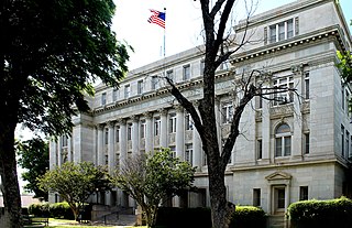
Eastland is a city in Eastland County, Texas, United States. The population was 3,609 at the 2020 census. It is the county seat of Eastland County.

Rising Star is a town in Eastland County, Texas, United States. Its population as of the 2020 census was 756.

Breckenridge is a city and county seat of Stephens County, Texas, Texas, United States. The estimated population was 5,349 as of February 2021. The mayor is Bob Sims.

New Martinsville is a city in and the county seat of Wetzel County, West Virginia, United States, along the Ohio River. The population was 5,186 at the 2020 census.
Palo Pinto Creek is a river in Eastland, Stephens, and Palo Pinto counties, Texas, United States. It is a tributary of the Brazos River.
Nimrod is an unincorporated community in Eastland County in the U.S. state of Texas. It is located on Farm to Market Road 569 and was originally settled in 1876. The town may have been called Monroe or Curtis, but was later changed to Nimrod for a biblical character of the same name.

Olden is an unincorporated community in Eastland County, Texas, United States. Olden has a post office, with the ZIP code 76466.
Alexander is an unincorporated community located in southern Erath County in Central Texas, United States. Alexander is located in the southern part of the county, along Texas State Highway 6 and Fm-914. The town was originally called: "Harper's Mill" when the Post Office was approved for operation around the 1870s. The name was changed in the 1880s, when the Texas Central line, part of the historic Katy Railroad, was built from east to west through the townsite on its way from the Waco area to Stamford, with a branch to Cross Plains from the line at De Leon. In 1907, the Stephenville North and South Texas Railway, part of the Cotton Belt Route, was constructed from north to south and intersected with the Katy's line in Alexander. This made the town an important community for business in the area. The Cotton Belt Route ran from Stephenville through to nearby Carlton. On October 17, 1934, the Cotton Belt Route was abandoned from Stephenville to Hamilton. The Katy Railroad remained through Alexander until its abandonment in the late 1960s. The Alexander post office closed in 1970 and the population remained at a steady 40 from the 1970s through 2000.
Purves is an unincorporated community in Erath County, Texas, United States. Purves is located in the southwestern part of the county, along Fm-219 South, seven miles south of the City of Dublin.

Eliasville is an unincorporated community in Young County, Texas, United States. Eliasville is located near the Clear Fork of the Brazos River at the intersection of Texas Farm Roads 1974, 3109, and 701, close to the Stephens County line in southwestern Young County, approximately 20 miles from Graham.
Clairette is an unincorporated community located in Erath County in Central Texas, United States.
Cisco High School is a public high school located in Cisco, Texas, United States and classified as a 2A school by the University Interscholastic League (UIL). It is part of the Cisco Independent School District located in western Eastland County. In 2013, the school was rated "Met Standard" by the Texas Education Agency.
Zarate is a census-designated place (CDP) in Starr County, Texas, United States. This was a new CDP for the 2010 census, with a population of 59.

Lake Leon is located in Eastland County and was created by the State Board of Water Engineers by impounding the Leon River. In reference to Abilene, Texas with a population of around 125,000, it is 68 miles east, and in reference to Eastland, Texas with a population of around 4,000, it is 10 miles southeast. Lake Leon is found in the Brazos River and in the Cross Timbers ecoregion, more specifically the Cross Timbers Grand Prairie ecoregion.
References
- ↑ U.S. Geological Survey Geographic Names Information System: Mangum, Texas
- ↑ Phillips, William Battle (1914). The Mineral Resources of Texas. University of Texas. Retrieved August 16, 2024.
