Related Research Articles

Middlemarch is a small town in the Otago region of New Zealand's South Island. It lies at the foot of the Rock and Pillar Range of hills in the broad Strath-Taieri valley, through which flows the middle reaches of the Taieri River. Since local government reorganisation in the late 1980s, Middlemarch and much of the Strath-Taieri has been administered as part of Dunedin city, the centre of which lies some 80 km to the southeast. Middlemarch is part of the Taieri electorate, and is currently represented in parliament by Ingrid Leary. Middlemarch has reticulated sewerage but no reticulated water supply. A description of 1903, that "[T]he summer seasons are warm, but not enervating, and the winters cold, but dry" is still true today.

The Taieri River is the fourth-longest river in New Zealand and is in Otago in the South Island. Rising in the Lammerlaw Range, it initially flows north, then east around the Rock and Pillar range before turning southeast, reaching the sea 30 kilometres (19 mi) south of Dunedin.

The Maniototo Plain, usually simply known as The Maniototo, is an elevated inland region in Otago, New Zealand. The region roughly surrounds the upper reaches of the Taieri River and the Manuherikia River. It is bounded by the Kakanui Range to the north and the Rock and Pillar Range to the southeast. It has a harsh, dry climate, ranging from over 30 °C in mid-summer to -15 °C in mid-winter.
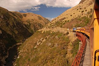
Dunedin Railways is the trading name of Dunedin Railways Limited, an operator of a railway line and tourist trains based at Dunedin Railway Station in the South Island of New Zealand. The company is a council-controlled trading organisation wholly owned by Dunedin City Council through its holding company Dunedin City Holdings Limited.
Strath Taieri is a large glacial valley and river plateau in New Zealand's South Island. It is surrounded by the rugged hill ranges to the north and west of Otago Harbour. Since 1989 it has been part of the city of Dunedin. The small town of Middlemarch is located at its southern end.

Danseys Pass is a mountain pass located in the Kakanui Range in the South Island of New Zealand.

Nagarjuna Sagar Dam is a masonry dam across the Krishna River at Nagarjuna Sagar which straddles the border between Palnadu district in Andhra Pradesh and Nalgonda district in Telangana. The dam provides irrigation water to the districts of Palnadu, Guntur, Nalgonda, Prakasam, Khammam, Krishna, and parts of West Godavari. It is also a source of electricity generation for the national grid.
Paerau is a small settlement in inland Central Otago in New Zealand's South Island. It is located in the Strath Taieri, the upper valley of the Taieri River, at the foot of the Rock and Pillar Range. "Paerau" is a Māori-language name meaning "one hundred ridges".
The Great Moss Swamp is located in Otago, New Zealand. It lies in the Maniototo, close to the former gold mining route of the Old Dunstan Road, 85 kilometres to the northwest of Dunedin city centre. It is classified as a regionally significant wetland.
The Rock and Pillar Range of high hills is located in the Maniototo, an area of inland Otago, New Zealand. They are surrounded by the Taieri River, which has its source in the range, flowing out across the scroll plain at Paerau, before almost doubling back on itself at Waipiata and flowing back along the other side through the Strath-Taieri. The town of Middlemarch lies close to the Taieri to the east of the range, and Patearoa lies to the northwest.

Hyde is a locality in Otago, New Zealand, located in the Strath-Taieri. It is close to the northern end of the Rock and Pillar Range on State Highway 87 between Middlemarch and Ranfurly. Hyde is best known as the site of the Hyde railway disaster of 4 June 1943, in which 21 people were killed when an express train on the Otago Central Railway derailed at high speed in a cutting near the town. At the time, it was the worst railway accident in New Zealand's history; it has only been passed by the Tangiwai disaster of 24 December 1953, which claimed the lives of 151 people. The site of the Hyde disaster can now be walked as part of the Otago Central Rail Trail and a monument, a 2.5 m high cairn, stands as a memorial to the victims.
Waipiata is an historic place on the Otago Central Rail Trail, in Central Otago, New Zealand. Waipiata is also the name of many New Zealand coastal vessels, steamers, freighters and steamships.

Lake Onslow is a man-made lake east of Roxburgh and south of Alexandra in the Otago region of New Zealand. It lies 700 m (2,300 ft) above sea level. It was formed in 1890 by the damming of the Teviot River and Dismal Swamp, with a new dam built in 1982 that raised the lake level by 5 m (16 ft). It is the site considered for a pumped-storage hydroelectricity project.
Styx Creek is a small to medium-sized natural stream in the Central Otago region of New Zealand. It flows into the Taieri River in the valley near Paerau, about 70 kilometres (43 mi) northwest of Dunedin.

Idamalayar Dam is a multipurpose concrete gravity dam located at Ennakkal between Ayyampuzha and Bhoothathankettu in Ernakulam district of Kerala on the Idamalayar, a tributary of the Periyar River in Kerala, South India. The dam however extends east as far as Malakkappara. Completed in 1985, with a length of 373 metres (1,224 ft) and a height of 102.8 metres (337 ft), the dam created a multipurpose reservoir covering 28.3 km2 (10.9 sq mi) in the scenic hills of the Anamalais.

State Highway 87 (SH 87) is a state highway in New Zealand servicing the Taieri Plains and the Strath-Taieri Valley in Otago, connecting Mosgiel to Kyeburn on the eastern flank of the Maniototo Plains.

The Tungabhadra Dam, also known as Pampa Sagar, is a water reservoir constructed across the Tungabhadra River in the city of Hosapete in Vijayanagara district, Karnataka, India. It is a multipurpose dam serving irrigation, electricity generation, flood control, etc. for the state. It is one of the only two non-cement dams in India, the other being the Mullaperiyar Dam in Kerala. The dam is built of surki mortar, a combination of mud and limestone, commonly used at the time of its construction.

Poolburn Reservoir, also known as Poolburn Dam, is a reservoir in Central Otago, New Zealand. Built during the Great Depression for irrigation but also as an employment initiative, the water is used by farmers in the Ida Valley.
The Dunstan Trail, also known as the Old Dunstan Road, is a historic route in Otago, New Zealand. The road was created during the Central Otago Gold Rush of the 1860s.
References
- ↑ "Maniototo Irrigation Company". Maniototo Irrigation Company. Retrieved 18 June 2023.
- ↑ "Maniototo Scheme 'Lifeblood' of Area". Otago Daily Times. Retrieved 18 June 2023.