
Staffordshire is a landlocked ceremonial county in the West Midlands of England. It borders Cheshire to the north-west, Derbyshire and Leicestershire to the east, Warwickshire to the south-east, the West Midlands county and Worcestershire to the south, and Shropshire to the west. The largest settlement is the city of Stoke-on-Trent, and the county town is Stafford.
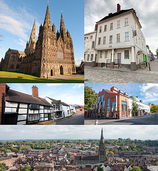
Lichfield is a cathedral city and civil parish in Staffordshire, England. Lichfield is situated 18 miles (29 km) south-east of the county town of Stafford, 9 miles (14 km) north-east of Walsall, 8 miles (13 km) north-west of Tamworth and 13 miles (21 km) south-west of Burton upon Trent. At the time of the 2021 Census, the population was 34,738 and the population of the wider Lichfield District was 106,400.

Shugborough Hall is a stately home near Great Haywood, Staffordshire, England.

Stafford is a market town and the county town of Staffordshire, England. It is located about 15 miles (24 km) south of Stoke-on-Trent, 15 miles (24 km) north of Wolverhampton, and 24 miles (39 km) northwest of Birmingham. The town had a population of 71,673 in 2021, and is the main settlement within the larger Borough of Stafford, which had a population of 136,837 in 2021.

Lichfield District is a local government district in Staffordshire, England. The district is named after its largest settlement, the city of Lichfield, which is where the district council is based. The district also contains the towns of Burntwood and Fazeley, along with numerous villages and surrounding rural areas, including part of Cannock Chase, a designated Area of Outstanding Natural Beauty.

Whittington is a village and civil parish which lies approximately 3 miles south east of Lichfield, in the Lichfield district of Staffordshire, England. According to the 2001 census it had a population of 2,591, increasing to 2,603 at the 2011 Census. The parish council is a joint one with Fisherwick. The Coventry Canal borders the village to the north and east.
Great Haywood is a village in central Staffordshire, England, just off the A51 and about 4.5 miles (7.2 km) northwest of Rugeley and 7.1 miles (11.4 km) southeast of the county town of Stafford. Population details taken at the 2011 census can be found under Colwich.

Beacon Park is a public park in the centre of the city of Lichfield, Staffordshire, in England. The park was created in 1859 when the Museum Gardens were laid out adjacent to the newly built Free Museum and Library. The park has since been extended in stages and now forms 69 acres (28 ha) of open parkland in the city centre. The park is in the northwest of the city centre and to the west of the Cathedral Close across the road from the Garden of Remembrance.
Ilam Park is a 158-acre (0.64 km2) country park situated in Ilam, on both banks of the River Manifold five miles (8 km) north west of Ashbourne, England, and in the ownership of the National Trust. The property is managed as part of the Trust's White Peak Estate.

Weeford is a village and civil parish in the Lichfield district of Staffordshire, England. According to the 2011 Census, the parish had a population of 215, an increase from 202 in the 2001 Census.

Hints is a small village and civil parish between Lichfield and Tamworth in southeastern Staffordshire, within Lichfield local government district. The village is on the line of Watling Street, which was formerly the A5, but the A5 now runs in a cutting north of the village. The name of the parish council is Hints with Canwell. The parish church is dedicated to St Bartholomew.

Roughley is an electoral ward within the Royal Town of Sutton Coldfield, and is the most northerly part of the administrative area covered by the Royal Sutton Coldfield Town Council and the City of Birmingham. Over half of Roughley Ward is attractive Green Belt countryside, including arable and dairy farms, historic field boundaries survive with mature hedgerows and woodlands. Several public footpaths provide access to the countryside and the one linking Hillwood Road and Dale Farm provides distant views of Lichfield Cathedral and on a clear day the Pennine Hills.
{
Colwich is a civil parish and village in Staffordshire, England. It is situated off the A51 road, about 3 miles (5 km) north-west of Rugeley and 7 miles (11 km) south-east of Stafford. It lies principally on the north-east bank of the River Trent, near Wolseley Bridge and just north of The Chase. The parish comprises about 2,862 hectares (28.62 km2) of land in the villages and hamlets of Colwich, Great Haywood, Little Haywood, Moreton, Bishton and Wolseley Bridge.

Maple Hayes is late 18th century manor house, now occupied by a special needs school, near Lichfield, Staffordshire. It is a Grade II listed building.

Thorpe Constantine is a small village and civil parish in Staffordshire, England. It lies about 6 miles (10 km) north-east of Tamworth and 6 miles south-west of Measham. The nucleus of the parish is the Thorpe estate.
Elmhurst Hall was a country house in the village of Elmhurst, Staffordshire. The house was located approximately 1.5 miles north of the city of Lichfield.

Samuel Peploe Wood was an English sculptor and painter. His sculpture can be seen on many churches and public buildings in England, and there are a number of his sketches and watercolours at Staffordshire County Museum.

Greenham Hall is a country house at Wellington in Somerset. It was once the home of Admiral of the Fleet Sir John Kelly. It is a Grade II listed building.
Weeford is a civil parish in the district of Lichfield, Staffordshire, England. The parish contains eight listed buildings that are recorded in the National Heritage List for England. All the listed buildings are designated at Grade II, the lowest of the three grades, which is applied to "buildings of national importance and special interest". The parish includes the village of Weeford and the surrounding countryside. The buildings in Weeford House Farm were at one time part of a large coach staging complex, and some of them are listed. The other listed buildings are a church, a farmhouse, and two lodges.