
Sierra Leone, officially the Republic of Sierra Leone, informally Salone, is a country on the southwest coast of West Africa. It has a tropical climate, with a diverse environment ranging from savanna to rainforests. The country has a total area of 71,740 km2 (27,699 sq mi) and a population of 7,075,641 as of the 2015 census. Sierra Leone is a constitutional republic with a directly elected president and a unicameral legislature. The country's capital and largest city is Freetown. Sierra Leone is made up of five administrative regions: the Northern Province, North West Province, Eastern Province, Southern Province and the Western Area. These regions are subdivided into sixteen districts.

Sierra Leone is located on the west coast of Africa, between the 7th and 10th parallels north of the equator. Sierra Leone is bordered by Guinea to the north and northeast, Liberia to the south and southeast, and the Atlantic Ocean to the west.

Sierra Leone maintains formal relations with many Western nations. It also maintains diplomatic relations with the former Soviet Bloc countries as well as with the People's Republic of China.

The Mano River Union (MRU) is an international association initially established between Liberia and Sierra Leone by the 3 October 1971 Mano River Declaration. It is named for the Mano River which begins in the Guinea highlands and forms a border between Liberia and Sierra Leone. On 25 October 1980, Guinea joined the union.

The Mano River is a river in West Africa. It originates in the Guinea Highlands in Liberia and forms part of the Liberia-Sierra Leone border.

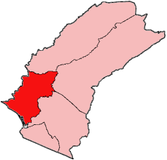
The Southern Province is one of the four provinces of Sierra Leone. It covers an area of 19,694 km² and has a population of 1,438,572. It consists of four districts. Its capital and administrative center is Bo, which is also the second largest and second most populated city in Sierra Leone after the nation's capital Freetown. The population of the southern province is largely from the Mende ethnic group.
"Diamonds from Sierra Leone" is a song by American hip-hop artist Kanye West. It was released on July 4, 2005, as the lead single of his second studio album, Late Registration. The song includes a sample of the song "Diamonds Are Forever" by Shirley Bassey and Bassey had praise for West after he sampled it. The song peaked at number 43 on the Billboard Hot 100, was moderately successful on the iTunes music service, and peaked at number 8 on the UK Top 40. It won a Grammy Award for Best Rap Song at the 48th Grammy Awards.
Tewor District is one of five districts located in Grand Cape Mount County, Liberia.
The Mamunta Mayosso Wildlife Sanctuary is a game reserve in Tonkolili District, Northern Province, Sierra Leone. It is one of the few areas in the country that protects the threatened Dwarf Crocodile as well as being home to 252 bird species despite its small size. It is situated between Magburaka and Yonibana.
The following list is of events that happened during 2007 in Sierra Leone.
Bo Waterside is a town in Grand Cape Mount County, Liberia on the Mano River. It was a key border crossing between Liberia and Sierra Leone until 1990, when it closed after the launch of Charles Taylor's National Patriotic Front of Liberia invasion from Sierra Leone. The border crossing officially re-opened in June 2007 in an official ceremony involving government officials, humanitarian workers and significant amounts of foreign press coverage.
Bradford is a town in western Sierra Leone, not far from the capital.
Tonkolele is a town in the mountains of central Sierra Leone.
Tagrin Point is the proposed location of a deep water port to replace the older and shallower port of Port Pepel in Sierra Leone. It would be connected to existing and new iron ore mined by an upgraded railway line converted to standard gauge.

United Nations Security Council resolution 1436, adopted unanimously on 24 September 2002, after recalling all previous resolutions on the situation in Sierra Leone, the Council extended the mandate of the United Nations Mission in Sierra Leone (UNAMSIL) for a further six months beginning on 30 September 2002.
The Leq' a: mel First Nation, formerly known as the Lakahahmen First Nation, is a First Nations band government whose community and offices are located in the area near Deroche, British Columbia, Canada, about 12 kilometres east of the District of Mission. They are a member government of the Sto:lo Nation tribal council, which is one of two tribal councils of the Sto:lo.

Guéckédou or Guékédou is a town in southern Guinea near the Sierra Leone and Liberian borders. It had a population of 79,140 in 1996 (census) but has grown massively since the civil wars and, as of 2008, it is estimated to be 221,715. It was a centre of fighting during the Second Liberian Civil War and the Sierra Leone Civil War in 2000 and 2001.

Panguma is a village in eastern Sierra Leone, with a population of 7965. The village had previously been the capital of Mende chief Nyagua during the 19th century.

Sir Samuel Rowe was a British doctor and colonial administrator who was twice governor of Sierra Leone, and also served as administrator of the Gambia, governor of the Gold Coast and governor-general of the West Africa settlements. He was known for his ability to form pro-British relationships with the local people. He was in favour of a vigorous programme of expansion from the coast into the interior in response to French activity in the Sahel region, at times in opposition to Colonial Office policy.
Group F of the 2019 Africa Cup of Nations qualification tournament was one of the 12 groups to decide the teams which qualify for the 2019 Africa Cup of Nations finals tournament. The group consisted of four teams: Ghana, Ethiopia, Sierra Leone, and Kenya, before Sierra Leone's disqualification.

