Mantare is one of 18 wards of the Kwimba District of the Mwanza Region in Tanzania. It is located at 33° 13' E, 2° 42' S. Like many of its neighboring wards, Mantare is inhabited by the Wasukuma people who speak Kisukuma and Swahili, the national language of Tanzania.
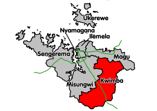
Kwimba District is one of the seven districts of the Mwanza Region of Tanzania. It is bordered to the north by the Magu District, to the east by Maswa District and Kishapu District, to the south by Shinyanga Rural District, and to the west by Misungwi District. The district seat is at Ngudu. Sumve is another important settlement in Kwimba District, hosting a hospital and large church.
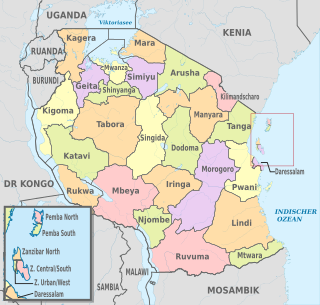
Mwanza Region is one of Tanzania's 31 administrative regions with a postcode number 33000. The regional capital is Mwanza.
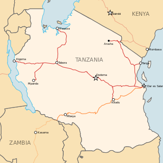
Tanzania officially the United Republic of Tanzania, is a country in eastern Africa within the African Great Lakes region. It borders Uganda to the north; Kenya to the northeast; Comoro Islands at the Indian Ocean to the east; Mozambique and Malawi to the south; Zambia to the southwest; and Rwanda, Burundi, and the Democratic Republic of the Congo to the west. Mount Kilimanjaro, Africa's highest mountain, is in north-eastern Tanzania.
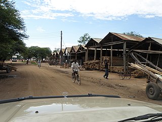
The landscape is quite rural, and much of the farmland is used for growing rice, corn, cassava, and cotton. Most of the inhabitants are subsistence farmers, though a few work in the institutions found in the nearby village of Sumve.
Sumve, Tanzania is located in the Kwimba District of the Mwanza Region, in Tanzania. Sumve's residents are predominantly from the Wasukuma tribe, the largest in Tanzania, but some of Sumve's institutions employ Wahaya, Wajita, Wakerewe, Wanyamwezi and others from neighboring tribes. Therefore, many of the residents speak Kisukuma along with Swahili, the national language. The population was 16,436 in 2012, making it the 15th most populous ward in the Kwimba district.
Railways
Mantare is the name of a train stop on the Tanzania Railways Corporation (TRC) line to Dar es Salaam, though the stop is actually found in the neighboring village of Ishingisha. The stop is approximately 53km to the terminus of the line in Mwanza.
Dar es Salaam (Dar) is the former capital as well as the most populous city in Tanzania and a regionally important economic centre. Located on the Swahili coast, the city is one of the fastest growing cities in the world.
Sport
Mantare, Sumve, and Ishingisha are all members of the Goat League, where each local soccer team competes against each other in a round robin tournament for the prize of a goat.
A geographic coordinate system is a coordinate system that enables every location on Earth to be specified by a set of numbers, letters or symbols. The coordinates are often chosen such that one of the numbers represents a vertical position and two or three of the numbers represent a horizontal position; alternatively, a geographic position may be expressed in a combined three-dimensional Cartesian vector. A common choice of coordinates is latitude, longitude and elevation. To specify a location on a plane requires a map projection.
This page is based on this Wikipedia article Text is available under the CC BY-SA 4.0 license; additional terms may apply. Images, videos and audio are available under their respective licenses.
Related Research Articles
Transport in Tanzania includes road, rail, air and maritime networks. The road network is 86,472 kilometres (53,731 mi) long, of which 12,786 kilometres (7,945 mi) is classified as trunk road and 21,105 kilometres (13,114 mi) as regional road. The rail network consists of 3,682 kilometres (2,288 mi) of track. Commuter rail service is in Dar es Salaam only. There are 28 airports, with Julius Nyerere International being the largest and the busiest. Ferries connect Mainland Tanzania with the islands of Zanzibar. Several other ferries are active on the countries' rivers and lakes.
The Sukuma are a Bantu ethnic group inhabiting the southeastern African Great Lakes region. They are the largest ethnic group in Tanzania, with an estimated 8.9 million members or 16 percent of the country's total population. Sukuma means "north" and refers to "people of the north." The Sukuma refer to themselves as Basukuma (plural) and Nsukuma (singular). They speak Sukuma, which belongs to the Bantu branch of the Niger-Congo family.
Shinyanga, also known as Shinyanga mji in the local Swahili language, is a city in northern Tanzania. The city is the location of the regional headquarters of Shinyanga Region as well as the district headquarters of Shinyanga Urban District. The region and district are named after the town.
Neville is a small village in the south-east of New South Wales, Australia, in Blayney Shire. It is 60 km south of Bathurst or about 16 km south-east of Mandurama. It is 940 metres above sea level and has a population of about 100.
The Central Line, formerly known as the Tanganyika Railway is the most important railway line in Tanzania apart from TAZARA. It runs west from Dar es Salaam to Kigoma on Lake Tanganyika via Dodoma. A branch leads to Mwanza on Lake Victoria.
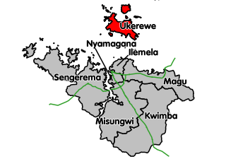
Ukerewe District is one of the seven districts of the Mwanza Region of Tanzania. It is located on Ukerewe Island, Ukara Island and other neighbouring islands within Lake Victoria. The largest settlement and the district's administrative capital is Nansio. As of 2002, the population of Ukerewe District was 261,944. By 2012, the official population of Ukerewe District was 345,147.
Misungwi District is one of the seven districts of the Mwanza Region of Tanzania. It is bordered to the north by Nyamagana District and Magu District, to the east by Kwimba District, to the south by Shinyanga Rural District and to the west by Nyang'hwale District and Lake Victoria. Misungwi is often spelled with an extra 's' to make it Missungwi. The administrative centre is in the town of Misungwi.
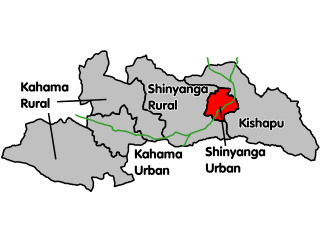
Shinyanga Urban District is one of the eight districts of the Shinyanga Region of Tanzania and includes the city of Shinyanga. It is bordered to the north by the Mwanza Region, to the south by the Shinyanga Rural District, to the east by the Kishapu District, and to the west by the Kahama District.
Nzega District is one of the seven districts of the Tabora Region of Tanzania. It is bordered to the north by Shinyanga Region, to the south and southwest by the Uyui District and to the east by the Igunga District. Its administrative seat is the town of Nzega.
Tabora Urban is one of the seven districts in the Tabora Region of Tanzania. This district is mostly the city of Tabora and its suburbs. It is bordered almost completely by the Uyui District. It has a small border with Nzega District to the north. Its administrative seat is the city of Tabora.
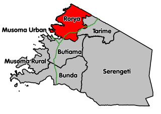
Rorya District is a district in Mara Region, United Republic of Tanzania. The district capital is the village of Ingri Juu, while the largest town is Shirati. The district was created in 2007 from a part of Tarime District. It is bordered by Tarime District to the east, Butiama District to the south, Lake Victoria to the west, and the Republic of Kenya to the north. The majority of inhabitants are from the Luo tribe. Other ethnic groups are Kurya, Kine, Simbiti,Sweta, Hacha, and Suba.
The administrative divisions of Tanzania are controlled by Part I, Article 2.2 of the Constitution of Tanzania. Tanzania is divided into thirty-one regions. Each region is subdivided into districts. The districts are sub-divided into divisions and further into local wards. Wards are further subdivided for management purposes: for urban wards into streets and for rural wards into villages. The villages may be further subdivided into hamlets.
Nansio is a small town and ward on the island of Ukerewe, Lake Victoria, in Tanzania. It is a port of entry for passenger and freight shipping services from Mwanza.
Isamilo International School Mwanza, founded in 1956, is an international school for students aged 3 to 18 in Mwanza, Tanzania. The school has been known as The Government European School, Isamilo Primary School and Isamilo School Mwanza before being renamed in 2008 to its present name, Isamilo International School Mwanza.
The Roman Catholic Diocese of Bunda is a diocese located in Bunda Town in the Ecclesiastical province of Mwanza in Tanzania.
The main natural resources in Tanzania are land, rivers, lakes, the ocean, and forests/woodlands. Natural resources are used for crops cultivation, grazing, wildlife, wood, fishing and minerals' mining.