
iLife is a discontinued software suite for macOS and iOS developed by Apple Inc. It consists of various programs for media creation, organization, editing and publishing. At various times, it included: iTunes, iMovie, iPhoto, iDVD, iWeb, and GarageBand. Only iMovie and GarageBand remain and are now freely available on Apple's Mac App Store. iDVD and iWeb have been discontinued while iTunes and iPhoto have been succeeded by Music and Photos respectively.

Flickr is an image hosting and video hosting service, as well as an online community, founded in Canada and headquartered in the United States. It was created by Ludicorp in 2004 and was previously a common way for amateur and professional photographers to host high-resolution photos. It has changed ownership several times and has been owned by SmugMug since April 20, 2018.

A geotagged photograph is a photograph which is associated with a geographic position by geotagging. Usually this is done by assigning at least a latitude and longitude to the image, and optionally elevation, compass bearing and other fields may also be included.

Image sharing, or photo sharing, is the publishing or transfer of digital photos online. Image sharing websites offer services such as uploading, hosting, managing and sharing of photos. This function is provided through both websites and applications that facilitate the upload and display of images. The term can also be loosely applied to the use of online photo galleries that are set up and managed by individual users, including photoblogs. Sharing means that other users can view but not necessarily download images, and users can select different copyright options for their images.
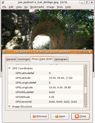
Geotagging, or GeoTagging, is the process of adding geographical identification metadata to various media such as a geotagged photograph or video, websites, SMS messages, QR Codes or RgSSfeeds and is a form of geospatial metadata. This data usually consists of latitude and longitude coordinates, though they can also include altitude, bearing, distance, accuracy data, and place names, and perhaps a time stamp.

Panoramio was a geo-located tagging, photo sharing mashup active between 2005 and 2016. Photos uploaded to the site were accessible as a layer in Google Earth and Google Maps. The site's goal was to allow Google Earth users to learn more about a given area by viewing the photos that other users had taken at that location. Panoramio was acquired by Google in 2007. In 2009 the website was among the 1000 most popular websites worldwide.

Microsoft Popfly was a Website that allowed users to create web pages, program snippets, and mashups using the Microsoft Silverlight rich web applications runtime and the set of online tools provided. It was discontinued on August 24, 2009.

Geosocial networking is a type of social networking in which geographic services and capabilities such as geocoding and geotagging are used to enable additional social dynamics. User-submitted location data or geolocation techniques can allow social networks to connect and coordinate users with local people or events that match their interests. Geolocation on web-based social network services can be IP-based or use hotspot trilateration. For mobile social networks, texted location information or mobile phone tracking can enable location-based services to enrich social networking.
Collaborative mapping, also known as citizen mapping, is the aggregation of Web mapping and user-generated content, from a group of individuals or entities, and can take several distinct forms. With the growth of technology for storing and sharing maps, collaborative maps have become competitors to commercial services, in the case of OpenStreetMap, or components of them, as in Google Map Maker, Waze and Yandex Map Editor.
Distributed GIS refers to GI Systems that do not have all of the system components in the same physical location. This could be the processing, the database, the rendering or the user interface. It represents a special case of distributed computing, with examples of distributed systems including Internet GIS, Web GIS, and Mobile GIS. Distribution of resources provides corporate and enterprise-based models for GIS. Distributed GIS permits a shared services model, including data fusion based on Open Geospatial Consortium (OGC) web services. Distributed GIS technology enables modern online mapping systems, Location-based services (LBS), web-based GIS and numerous map-enabled applications. Other applications include transportation, logistics, utilities, farm / agricultural information systems, real-time environmental information systems and the analysis of the movement of people. In terms of data, the concept has been extended to include volunteered geographical information. Distributed processing allows improvements to the performance of spatial analysis through the use of techniques such as parallel processing.
Real-time geotagging refers to the automatic technique of acquiring media, associating a specific location with the media, transferring the media to an online map and publishing the media in real time. It is thus an extension of an automatic geotagging process, requiring an in-built or attached location acquisition device, but also requires communication with a wireless data transfer device. Most modern smartphones and several digital cameras already integrate camera, aGPS, and wireless data transfer into one device, thus directly producing a geotagged photograph. Real-time geotagging is sometimes referred to as "mobile geotagging" or "autogeotagging", but this does not imply the real-time publishing step.
MobileMe is a discontinued subscription-based collection of online services and software offered by Apple Inc. All services were gradually transitioned to and eventually replaced by the free iCloud, and MobileMe ceased on June 30, 2012, with transfers to iCloud being available until July 31, 2012, or data being available for download until that date, when the site finally closed completely. On that date all data was deleted, and email addresses of accounts not transferred to iCloud were marked as unused.
Brightkite was a location-based social networking website. Users were able to "check in" at places by using text messaging or one of the mobile applications and they were able to see who is nearby and who has been there before. The service was created in 2007 by Brady Becker, Martin May, and Alan Seideman who previously founded the SMS notification service Loopnote. In April 2009 Brightkite was acquired by mobile social network Limbo.
Plazes AG was a Berlin, Germany-based geosocial networking site. Plazes allowed users to post their location and current activities and share this information with other Plazes users via computers or mobile telephones. On 23 June 2008, Nokia Corporation announced plans to acquire Plazes. Plazes was subsequently integrated to Nokia Maps which itself was integrated to HERE Maps.
GeoReader is a landmark locating software application and website for mobile iPhone and Android based devices. Users travel into the vicinity of a "talking point", and the software enables the phone to read text aloud that is linked with a GPS location. In addition, users can create their own 200 character count text to add to the database, and choose to share these talking points publicly or privately. The system is hands free and requires no physical interaction. Once the app is installed in the mobile device, the user simply opens the app and starts their trip. The application automatically then starts to search for any GPS tagged talking points within range of the user.
GeoTime is geospatial analysis software that allows the visual analysis of events over time. It adds time as the third dimension to a two-dimensional map, allowing users to see changes within time series data. Users can view real-time animated playback of data and use automated analysis tools within the software to identify location patterns, connections between events, and trends.
GyPSii is a provider of geosocial networking applications and services for the iPhone, iPod, iPad, BlackBerry OS, Android and Java-based phones, Symbian S60 and S40, Windows Mobile and MID notebooks. The company is headquartered in Amsterdam, Netherlands, with offices in Asia and the United States.

WorldMap is a web platform for creating, displaying, analyzing, and searching spatial data and other data forms across multiple disciplines.
Geomessaging is a technology that allows a person or system to send a message based on any media to a device that enters or exits one or more regions. Those regions can be created by using geofences, based on Latitude and Longitude, or adding beacons to the system associating those beacons with named locations. The device will receive the message according to the rules defined by the campaign administrator.
