Related Research Articles
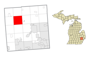
Springfield Charter Township is a charter township of Oakland County in the U.S. state of Michigan. As of the 2010 census, the township population was 13,940. The township was named for the numerous springs in the area.
Chester Township is a civil township of Ottawa County in the U.S. state of Michigan. As of the 2000 United States Census, the township population was 2,315.

The Grand River is a river in the southwestern portion of the southern peninsula of Michigan, United States, that flows into Lake Michigan's southeastern shore. It is the longest river in Michigan, running 252 miles (406 km) from its headwaters in Hillsdale County on the southern border north to Lansing and west to its mouth on the Lake at Grand Haven.
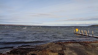
Burt Lake is a 17,120 acre (69 km2) lake in Cheboygan County in the U.S. state of Michigan. The western shore of the lake is on the boundary with Emmet County. The lake is named after William Austin Burt, who, together with John Mullett, made a federal survey of the area from 1840 to 1843.

Bear River is a small clear slow-moving river in the U.S. state of Michigan. 14.7 miles (23.7 km) long, it is the largest tributary of Little Traverse Bay in the northwest of the lower peninsula. Traverse Bay is on Lake Michigan. The river is formed as the outflow of Walloon Lake on the boundary between Charlevoix County and Emmet County, draining from the southeast end of the lake at 45°15′40″N84°56′01″W near the community of Walloon Lake in Melrose Township. M-75 has its northern terminus in a junction with US 131 nearby.

Pine River may refer to any of the following rivers in the U.S. state of Michigan:
White Lake is the name of several lakes in the U.S. state of Michigan. The largest one is formed by the White River flowing to its mouth on Lake Michigan in Muskegon County.
Wabaningo is a small unincorporated community of Fruitland Township, Muskegon County in the U.S. state of Michigan. It is situated where the White Lake flows through a short navigation channel into Lake Michigan at 43°22′31″N86°25′36″W.
The Cass River is a 61.5-mile-long (99.0 km) river in the Thumb region of the U.S. state of Michigan. It drains large portions of Sanilac and Tuscola counties and smaller portions of Genesee, Huron, Lapeer, and Saginaw counties.
The Galien River is a 30.0-mile-long (48.3 km) stream in the southwest region of the U.S. state of Michigan. The river begins at the outlet of Dayton Lake and flows in a predominantly westerly direction until it enters southeastern Lake Michigan at New Buffalo. The South Branch Galien River rises just north of the border with Indiana, at the confluence of Spring Creek and the Galena River, the latter rising in LaPorte County, Indiana.
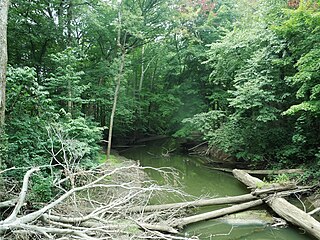
Cedar Creek may refer to several small streams in the U.S. state of Michigan:

Merritt is an unincorporated community in Missaukee County in the U.S. state of Michigan. The community is centered between Butterfield Township to the south and Enterprise Township to the north. As an unincorporated community, Merritt has no legally defined boundaries or population statistics of its own but does have its own post office with the 49667 ZIP Code.

The Hersey River is a 13.4-mile-long (21.6 km) stream in the Lower Peninsula of the U.S. state of Michigan. It rises in Lincoln Township in northwest Osceola County at the junction of Hersey Creek and the East Branch Hersey Creek at 43°50′55″N85°25′59″W. For approximately the first two miles, the river flows southward just east of U.S. Route 131. US 131 crosses the river near the northern boundary of Richmond Township. The river continues southward into Lake No Sho Mo, formed by a dam just south of Nartron Field airport. The river continues southward under U.S. Route 10 into Reed City and turns to the east, continuing southeastward into the village of Hersey, where it empties into the Muskegon River at Blodgett's Landing Campground.
The Little Maple River is a 16.5-mile-long (26.6 km) tributary of the Maple River in the central part of the Lower Peninsula of the U.S. state of Michigan. It rises in Victor Township, Clinton County at the outlet of Cedar Lake. It flows through Sleepy Hollow State Park which surrounds Lake Ovid. Lake Ovid was created by damming the Little Maple River. The Little Maple River joins the Maple River in Ovid Township, Clinton County.

Sturgeon River may refer to any of the following streams in the U.S. state of Michigan:

Sturgeon River is a 40.8-mile-long (65.7 km) river in the U.S. state of Michigan, flowing mostly northward through Otsego and Cheboygan counties.
The Maple River is a 74.1-mile-long (119.3 km) tributary of the Grand River in the central part of the Lower Peninsula of the U.S. state of Michigan. It rises in Shiawassee Township, Shiawassee County south of the city of Owosso. It flows west through Clinton, Gratiot and Ionia counties, flowing into the Grand River at Muir. Other cities it flows through along the way include Ovid, Elsie and Maple Rapids.

Misteguay Creek is a tributary of the Flint River, 38.4 miles (61.8 km) long, on the central Lower Peninsula of Michigan in the United States. The stream drains an area of 174.4 square miles (452 km2) in predominantly agricultural areas of the Flint/Tri-Cities region. Via the Flint and Shiawassee rivers, it is part of the watershed of the Saginaw River, which flows to Saginaw Bay of Lake Huron. Via Lake Huron and the Great Lakes system, it is part of the larger watershed of the St. Lawrence River.
The Maple River, which flows into Burt Lake, is a major river in the northern tip of the Lower Peninsula of the U.S. state of Michigan. The river drains sections of Cheboygan County and Emmet County, and provides an outflow for the 3,395-acre (1,374 ha) Douglas Lake.
References
If an internal link incorrectly led you here, you may wish to change the link to point directly to the intended article.