Related Research Articles

Venice is a residential, commercial, and recreational beachfront neighborhood within Los Angeles, California. It is located within the urban region of western Los Angeles County known as the Westside.

Hollywood is a neighborhood in the central region of Los Angeles, California, notable as the home of the U.S. film industry, including several of its historic studios. Its name has come to be a shorthand reference for the industry and the people associated with it.
Palms is a highly diverse, densely populated community in the Westside region of Los Angeles, California, founded in 1886 and the oldest neighborhood annexed to the city, in 1915. The 1886 tract was marketed as an agricultural and vacation community. Today it is a primarily residential area, with many apartment buildings, ribbons of commercial zoning and a single-family residential area in its northwest corner.

Mar Vista is a residential and commercial neighborhood on the Westside of Los Angeles, California. It is the home of Venice High School, two private schools, a branch public library and a city park.

West Los Angeles is an area within the city of Los Angeles, California. The residential and commercial neighborhood is divided by the Interstate 405 freeway, and each side is sometimes treated as a distinct neighborhood, mapped differently by different sources. Each lies within the larger Westside region of Los Angeles County.

Baldwin Hills is a neighborhood within the South Los Angeles region of Los Angeles California. It is home to Kenneth Hahn State Regional Park and to Village Green, a National Historic Landmark.
A Little India is an ethnic enclave containing a large population of Indian people within a particular area. It may also refer to an area with a high concentration of South Asian shops and restaurants.

Playa Vista is a neighborhood in the Westside area of Los Angeles, California. The area was the headquarters of Hughes Aircraft Company from 1941 to 1985 and the site of the construction of the Hughes H-4 Hercules "Spruce Goose" aircraft. The area began development in 2002 as a planned community with residential, commercial, and retail components. The community attracted businesses in technology, media and entertainment and, along with Santa Monica and Venice, Marina del Rey, Playa del Rey, Culver City, El Segundo and Mar Vista, has become known as Silicon Beach.

Venice High School is located in the westside Los Angeles, in the U.S. state of California within the Local District West area of the Los Angeles Unified School District (LAUSD).
Del Rey is a highly diverse neighborhood in the Westside of Los Angeles, surrounded on two sides by Culver City, California. With a population of 32,000+, it is home to a diverse population ranging from military veterans to sizable Latino and Asian populations. The business community is home to both tech and creative media companies with offices of companies such as Zephyr, Snapchat, Bouqs, Tom's Shoes, Gehry Partners, LLP, and Media Arts Lab, to family owned and local businesses.
Mid-Wilshire is a neighborhood in the central region of Los Angeles, California. It is known for the Los Angeles County Museum of Art, the Petersen Automotive Museum, and the Miracle Mile shopping district.
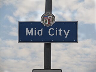
Mid-City is a neighborhood in Central Los Angeles, California.

Shadow Hills is a semi-rural neighborhood in the Verdugo Mountains and northeastern San Fernando Valley, within the city of Los Angeles, California.

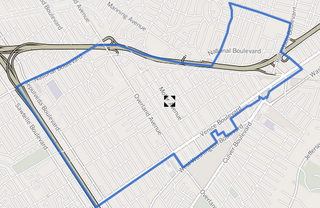
Westside Village is a residential neighborhood on the westside of Los Angeles County, California, bounded by National Boulevard to the north, Charnock Road to the south, Overland Avenue to the east and Sepulveda Boulevard to the west. The neighborhood shares a 90034 zip code with Palms, but Westside Village is designated "Zone 1" of the Mar Vista Community Council.
The Imperial Highway is a west-east thoroughfare in the counties of Los Angeles, Orange, Riverside, San Diego, and Imperial in California. The main portion of the existing route begins at Vista Del Mar in Los Angeles near the Los Angeles International Airport and ends at the Anaheim–Orange city line at Via Escola where it becomes Cannon Street. Historically, the Imperial Highway extended from Vista Del Mar to Calexico, where a portion of the highway still exist. The original route was replaced with other highways, rendering the older portions of the Imperial Highway to fall out of use.
Venice Boulevard is a major east–west thoroughfare in Los Angeles, running from the ocean in the Venice district, past the I-10 intersection, into downtown Los Angeles. It was originally known as West 16th Street under the Los Angeles numbered street system.
Los Angeles City Council District 11 is one of the 15 districts of the Los Angeles City Council, representing the Westside of the city to the Pacific Ocean. Mike Bonin is the district's current representative on the City Council.

Expo Park/USC is an at-grade light rail station in the Los Angeles County Metro Rail system. It is located at Exposition Boulevard and Trousdale Parkway, directly between the USC campus and Exposition Park, in the University Park neighborhood of Los Angeles, California. It also serves the Los Angeles Memorial Coliseum and Banc of California Stadium. This station is served by the E Line.

26th Street/Bergamot is an at-grade light rail station in the Los Angeles County Metro Rail system. It is located near the intersection of 26th Street and Olympic Boulevard in Santa Monica, California. The station is served by the E Line.
Los Angeles City Council District 6 is one of the 15 districts of the Los Angeles City Council, covering much of the central and eastern San Fernando Valley. It is represented by Councilmember Nury Martinez.
References
- ↑ "Archived copy". Archived from the original on 2014-02-22. Retrieved 2014-02-12.CS1 maint: archived copy as title (link)
- ↑ "Archived copy". Archived from the original on 2014-02-22. Retrieved 2014-02-12.CS1 maint: archived copy as title (link)
| This article about an organization in the United States is a stub. You can help Wikipedia by expanding it. |