
The Coral Sea Islands Territory is an external territory of Australia which comprises a group of small and mostly uninhabited tropical islands and reefs in the Coral Sea, north-east of Queensland, Australia. The only inhabited island is Willis Island. The territory covers 780,000 km2 (301,160 sq mi), most of which is ocean, extending east and south from the outer edge of the Great Barrier Reef and includes Heralds Beacon Island, Osprey Reef, the Willis Group and fifteen other reef/island groups. Cato Island is the highest point in the Territory.

The Venetian Lagoon is an enclosed bay of the Adriatic Sea, in northern Italy, in which the city of Venice is situated. Its name in the Italian and Venetian languages, Laguna Veneta—cognate of Latin lacus, "lake"—has provided the English name for an enclosed, shallow embayment of salt water, a lagoon.

The Solomon Islands rain forests are a terrestrial ecoregion covering the Solomon Islands archipelago.

The Maldives are formed by 20 natural atolls, along with a few islands and isolated reefs today which form a pattern stretching from 7 degrees 10′ North to 0 degrees 45′ South. The largest of these atolls is Boduthiladhunmathi, while the atoll containing the most islands is Huvadhu.

Malaita Province is the most populous and one of the largest of the nine provinces of Solomon Islands. It is named after its largest island, Malaita. Other islands include South Malaita Island, Sikaiana Island, and Ontong Java Atoll. Britain defined its area of interest in the Solomons, including Malaita, and central government control of Malaita began in 1893, when Captain Gibson R.N., of HMS Curacoa, declared the southern Solomon Islands as a British Protectorate with the proclamation of the British Solomon Islands Protectorate.

Kayangel (Ngcheangel) is the northernmost state of Palau 24 km (15 mi) north of Koror. The land area is about 1.4 km2 (0.54 sq mi). The population is 54. There is one hamlet in the state - Orukei which is also its capital.

The Solomon Sea is a sea located within the Pacific Ocean. It lies between Papua New Guinea and Solomon Islands. Many major battles were fought there during World War II.
South Malaita Island is the island at the southern tip of the larger island of Malaita in the eastern part of the Solomon Islands. It is also known as Small Malaita and Maramasike for Areare speakers and Malamweimwei for more than 80% of the islanders. The island is referred to as Iola Raha. It is called "small" to distinguish it from the much larger sibling. It is part of Malaita Province. South Malaita came under effective control of the colonial administration after the Solomon Islands was declared a British Protectorate in 1893. During the colonial days, the island was divided by the colonial government and missionary establishments into the Asimeuri, Asimae, and Raroisu'u districts.

Malaita is the primary island of Malaita Province in Solomon Islands. Malaita is the most populous island of the Solomon Islands, with a population of 161,832 as of 2021, or more than a third of the entire national population. It is also the second largest island in the country by area, after Guadalcanal.
Sikaiana is a small atoll 212 kilometres NE of Malaita in Solomon Islands in the south Pacific Ocean. It is almost 14 kilometres in length and its lagoon, known as Te Moana, is totally enclosed by the coral reef. Its total land surface is only 2 square kilometres. There is no safe anchorage close to this atoll, which makes it often inaccessible to outsiders.

The Chesterfield Islands are a French archipelago of New Caledonia located in the Coral Sea, 550 km (300 nmi) northwest of Grande Terre, the main island of New Caledonia. The archipelago is 120 km long and 70 km broad, made up of 11 uninhabited islets and many reefs. The land area of the islands is less than 10 km2.

Apo Reef is a coral reef system in the Philippines situated in the western waters of Occidental Mindoro province in the Mindoro Strait. Encompassing 34 square kilometres (13 sq mi), it is considered the world's second-largest contiguous coral reef system, and is the largest in the country. The reef and its surrounding waters are protected areas administered as the Apo Reef Natural Park (ARNP). It is one of the best known and most popular diving regions in the country, and is in the tentative list for UNESCO World Heritage Sites.
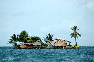
Lau Lagoon is a part of the Solomon Islands. It is located on the northeast coast of Malaita Island. The lagoon is more than 35 kilometers long and contains about 60 artificial islands built on the reef.
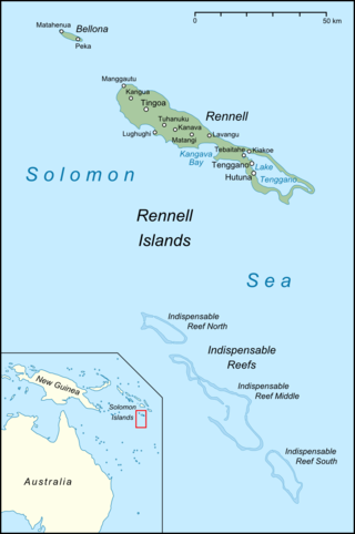
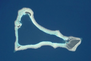
The Indispensable Reefs are a chain of three large coral atolls in the Coral Sea. They are located about 50 km (30 mi) south of Rennell Island. The chain stretches over a length of 114 km (71 mi) and its average width is 18 km (11 mi).

Raraka, or Te Marie, is an atoll in the west of the Tuamotu group in French Polynesia. It lies 17 km to the southeast of Kauehi Atoll.
Funaafou or Funa'afou is an artificial island built on the reef in the Lau Lagoon off the northeast coast of Malaita Island. Administratively, it is in the Malaita Province of the Solomon Islands. Funa'afou island, which is near the edge of the Makwanu Passage, has about 200 inhabitants. It is the first artificial Island built in the Lau lagoon. According to history, the people of Baleo tribe are the first descendants of Funafou Islands

Laulasi island is an artificial island in the Langa Langa Lagoon, South of Auki on the island of Malaita in the Solomon Islands. It is believed that hostilities among the inlanders of Malaita forced some people into the lagoon where over time they built their islands on sandbars after diving for coral. The religion of the island was based on prayers and offerings to the ghosts of dead ancestors, mediated by priests who kept their skulls and relics in tabu houses. Some ancestors were incarnated as sharks which protected their descendants. Langalanga is also the main source of the shell money now made in Solomon Islands.

Langa Langa Lagoon or Akwalaafu is a natural lagoon on the West coast of Malaita near the provincial capital Auki within the Solomon Islands. The lagoon is 21 km in length and just under 1 km wide. The "lagoon people" or "salt water people" live on small artificial islands built up on sand bars over time where they were forced to flee from the headhunters of mainland Malaita.
Adagege, alternatively spelled Ada Gege or Ada-gege, is an artificial island built on the reef in the Lau Lagoon on Malaita in the Solomon Islands; it is located in Malaita Province. The road from Auki ends at Fouia wharf opposite the islands of Sulufou and Adaege in the Lau Lagoon.

The Coral reefs of the Solomon Islands consists of six major islands and over 986 smaller islands, in Oceania, to the east of Papua New Guinea and northwest of Vanuatu. The Solomon Islands lie between latitudes 5° and 13°S, and longitudes 155° and 169°E. The distance between the westernmost and easternmost islands is about 1,500 km (930 mi). The Santa Cruz Islands are situated north of Vanuatu and are especially isolated at more than 200 km (120 mi) from the other islands. The Solomon Islands has the 22nd largest Exclusive Economic Zone of 1,589,477 km2 (613,701 sq mi) of the Pacific Ocean.
