Related Research Articles
Trinidad and Tobago, a country that relies heavily on industrialisation and tourism, has various transport systems.

Port of Spain (officially the City of Port of Spain, is the capital of Trinidad and Tobago and the third largest municipality, after Chaguanas and San Fernando. The city has a municipal population of 49,031, an urban population of 544,949 and a transient daily population of 250,000. It is located on the Gulf of Paria, on the northwest coast of the island of Trinidad and is part of a larger conurbation stretching from Chaguaramas in the west to Arima in the east with an estimated population of 600,000.
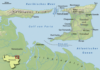
The Gulf of Paria is a 7,800 km2 (3,000 sq mi) shallow semi-enclosed inland sea located between the island of Trinidad and the east coast of Venezuela. It separates the two countries by as little as 15 km at its narrowest and 120 km at its widest points. The tides within the Gulf are semi-diurnal in nature with a range of approximately 1m. The Gulf of Paria is considered to be one of the best natural harbors on the Atlantic coast of the Americas. The jurisdiction of the Gulf of Paria is split between Trinidad and Tobago and Venezuela with Trinidad and Tobago having control over approximately 2,940 km2 (1,140 sq mi) (37.7%) and Venezuela the remainder (62.3%).

The Asa Wright Nature Centre and Lodge is a nature resort and scientific research station in the Arima Valley of the Northern Range in Trinidad and Tobago. The centre is one of the top birdwatching spots in the Caribbean; a total of 256 species of birds have been recorded there. The centre is owned by a non-profit trust.

The Northern Range is the range of tall hills across north Trinidad, the major island in the Republic of Trinidad and Tobago. The hills range from the Chaguaramas peninsula on the west coast to Toco in the east. The Northern Range covers approximately twenty-five percent of the land area of Trinidad.

The Panyols are a pardo or moreno (tri-racial) ethnic group in Trinidad and Tobago of Afro-Spanish-Indigenous descent, primarily of mixed South American Amerindian, Trinidad and Tobago Amerindian, Afro-Trinidadian, Afro-Venezuelans and Spanish descent. The name is a derivation of the word 'español', as well as the community's settlement in what became predominantly cocoa cultivated regions of Trinidad. Also referred to as Pagnols or Payols, the panyol communities draw cultural influence from both sides of the Gulf of Paria, and are predominantly found within the Northern Range rainforest mountains and valleys of Trinidad, with South American cultural influences most predominantly derived from regions around the Orinoco, and Caura River, Venezuela.

Diego Martin is a town and is the urban commercial center and capital of the Diego Martin region in Trinidad and Tobago. Its location in the region is just on the south eastern border, west of the capital city of Port of Spain and east of the town of Carenage. Diego Martin town in the Northern Range was once filled with a number of small valleys but is now a densely populated area. It was named after a Spanish explorer Don Diego Martín. The area was settled by French planters and their slaves in the 1780s. It consists of a cluster of communities including Congo Village, Diamond Vale, Green Hill, Patna Village, Petit Valley, Blue Range, La Puerta Avenue, Four Roads, Rich Plain, River Estate, Blue Basin, Water Wheel, West Moorings, Bagatelle and Sierra Leone.
Ellerslie Park is an exclusive residential development in the northwestern corner of Port of Spain, Trinidad and Tobago. The development is in the shape of an oval with a single entrance. No two homes are the same, a result of each home being built to the specifications of its original owner. Apart from private homes, Ellerslie Park is also the location of official residencies belonging to senior government officials and foreign diplomats. It is located within walking distance of the Queen's Park Savannah and various hotels and shopping facilities.

Trinidad and Tobago, officially the Republic of Trinidad and Tobago, is the southernmost island country in the Caribbean. Consisting of the main islands Trinidad and Tobago and numerous much smaller islands, it is situated 11 kilometres off the coast of northeastern Venezuela and 130 kilometres south of Grenada. It shares maritime boundaries with Barbados to the east, Grenada to the northwest, Saint Vincent and the Grenadines to the north and Venezuela to the south and west. Trinidad and Tobago is generally considered to be part of the West Indies. The island country's capital is Port of Spain, while its largest and most populous city is San Fernando.

Fatima College is a government-assisted, Roman Catholic boys' secondary school in Port of Spain, Trinidad and Tobago. It was established in 1945 and had an enrollment of 895 students as of 2006. The school was established and is run by the Holy Ghost Fathers, an international Roman Catholic religious community.

The National Museum and Art Gallery is the national museum of Trinidad and Tobago, in Port of Spain on Trinidad island. It is located at the top of Frederick Street, opposite the Memorial Park, and just south of the Queen's Park Savannah.
Nicholas Tower, situated on Independence Square, Port of Spain, Trinidad and Tobago is the fifth tallest building in Trinidad and Tobago. It has an elliptical floor plate and stands 21 floors tall and 88 Meters high. Construction was completed in 2003 and each floor, 8,000 square feet (700 m2) of space, was rented out at a cost of $96,000 a month. It is a blue glass tower.

Queen's Park Savannah (QPS) is a park in Port of Spain, Trinidad and Tobago. Known locally as simply "the Savannah", it is Port of Spain's largest open space. It occupies about 260 acres (110 ha) of level land, and the distance around the perimeter is about 2.2 mi (3.5 km).

Maraval is one of the northern suburbs of Trinidad's capital, Port of Spain, a valley in northern Trinidad in Trinidad and Tobago. It is situated at the bottom of the hills of Paramin and located east of the Diego Martin valley to which it is connected directly by Morne Coco Road, and west of Santa Cruz valley, to which it is connected by Saddle Road.

The Port of Spain International Waterfront Centre is a construction project aimed at revitalising and transforming the waterfront of the capital-city Port of Spain located in Trinidad and Tobago. The project is a part of the overall Vision 2020, a government policy attempting to take Trinidad and Tobago to developed country status by 2020. That policy has since been shelved. The towers, which were supposed to usher in the beginning of a "Financial Centre" never materialized, and have slowly been occupied by government departments and offices.

The Caribbean is a subregion of the Americas that includes the Caribbean Sea and its islands, some of which are surrounded by the Caribbean Sea and some of which border both the Caribbean Sea and the North Atlantic Ocean; the nearby coastal areas on the mainland are often also included in the region. The region is southeast of the Gulf of Mexico and the North American mainland, east of Central America, and north of South America.

The Magnificent Seven is a group of seven mansions located west of the Queen's Park Savannah in northern Port of Spain, Trinidad and Tobago on Maraval Road in the St Clair neighborhood. They were built between 1902 and 1910 on land that was previously used as a government stock farm and are listed as heritage sites at the National Trust of Trinidad and Tobago. Stollmeyer's Castle was the first building in the neighborhood and took several years to complete, as was typical of the Magnificent Seven.

Belmont, in north-east Port of Spain, in the Republic of Trinidad and Tobago, is located at the foot of the Laventille Hills; it was the city's first suburb. In the 1840s–'50s, parts of the area were settled by Africans rescued by the Royal Navy from illegal slaving ships. In the 1880s–'90s, the population swelled rapidly, and the characteristic Belmont street pattern of narrow, winding lanes developed. The black professional class built large homes in Belmont, as they were excluded from the more expensive neighbourhoods such as St. Clair and Maraval; Belmont became known as "the Black St. Clair". Many of these large homes have been renovated and converted to business use, but some remain in family hands. Belmont currently is a lower-middle to middle-class residential neighbourhood. It was the birthplace and early home of many important Carnival designers and bandleaders. Belmont has 9,035 inhabitants.
Saint Clair is a quiet, spacious, and upscale business and residential district between the Queen's Park Savannah and the Maraval River in Port of Spain, Trinidad and Tobago. It is home to most of the city's grandest and largest mansions and also home to the Magnificent Seven Houses. Federation Park and Ellerslie Park. St Clair is one of Port of Spain's five police districts.
References
- ↑ "Maraval River: Trinidad and Tobago". Geographic Names. Retrieved 20 May 2020.
- ↑ United States. Office of Geography (1955). British West Indies and Bermuda; Official Standard Names Approved by the United States Board on Geographic Names. U.S. Government Printing Office. United States Board on Geographic Names. p. 138.
- 1 2 Bissessarsingh, Angelo (1 December 2013). "The Maraval Reservoir". Trinidad and Tobago Guardian . Retrieved 20 May 2020.
- ↑ Richardson, Bonham C. (2005). Igniting the Caribbean's Past: Fire in British West Indian History. University of North Carolina Press. ISBN 9780807864081.
10°39′34″N61°32′14″W / 10.65944°N 61.53722°W