
The Telford Steam Railway (TSR) is a heritage railway located at Horsehay, Telford in Shropshire, England, formed in 1976.
Wivelsfield railway station is on the Brighton Main Line in West Sussex, England. The station is located in northern Burgess Hill and primarily serves the town's neighbourhoods of World's End and Sheddingdean. It is 40 miles 52 chains (65.4 km) down the line from London Bridge via Redhill and is situated between Haywards Heath and Burgess Hill on the main line. It is managed by Southern which is one of two companies serving Wivelsfield; the other one being Thameslink. Until May 2018, Gatwick Express also served the station with a single early-morning service towards London.

Wolverton railway station serves northern Milton Keynes, Buckinghamshire, especially Wolverton, Stony Stratford, New Bradwell, and nearby villages in south Northamptonshire. The station is on the West Coast Main Line, about 52 miles (84 km) from Euston, between Milton Keynes Central and Northampton. The station is one of the six stations serving the Milton Keynes urban area.

Dovey Junction railway station is a railway station on the Cambrian Line in Wales. It is the junction where the line splits into the line to Aberystwyth and the Cambrian Coast Line to Pwllheli. Passenger services are provided by Transport for Wales. There is a single island platform.

Leicester Belgrave Road was the Great Northern Railway terminus in Leicester, England. It was the terminus of the GNR's branch line from the Great Northern and London and North Western Joint Railway at Marefield Junction.
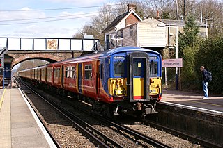
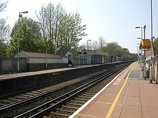
Effingham Junction railway station is just north of the far northern border of the village of Effingham, closer to the centre of East Horsley, homes of which it borders, in Surrey, England. Although the station takes its name from the former town, and the immediate vicinity has itself become known as Effingham Junction, it is actually in the latter. Effingham Junction is at the junction of the New Guildford Line, from London Waterloo to Guildford, and the line from Leatherhead, which carries trains from Waterloo via Epsom. It is 21 miles 10 chains (34.0 km) down the line from Waterloo.
Andoversford and Dowdeswell railway station was on the Midland and South Western Junction Railway in Gloucestershire. The station opened to passengers on 1 August 1891 with the opening of the section of the line between Cirencester Watermoor and the junction at Andoversford with the Great Western Railway's Cheltenham Lansdown to Banbury line, which had opened in 1881.

Whitacre Junction railway station was opened in 1864 by the Midland Railway.

Manton railway station or Manton Junction is a former railway station serving the villages of Manton and Wing in the county of Rutland.

Little Bytham railway station was a station in Little Bytham, Lincolnshire on the Great Northern Railway main line. It closed in 1959. The Midland and Great Northern Joint Railway crossed just north of the station. The GNR were given powers to build a junction but never did so. The nearest station on the M&GNR was at Castle Bytham.

Great Ponton railway station was a station on the East Coast Main Line at Great Ponton, Lincolnshire, England. The Great Northern Railway opened it in 1853 and British Railways closed it in 1958.
Hallaton railway station was a former railway station serving the village of Hallaton, Leicestershire, on the Great Northern and London and North Western Joint Railway. The station was located about a quarter of a mile east of the village on the road to Horninghold. The station opened in 1879 and closed to regular traffic in 1953. The Leicester to Peterborough service was withdrawn in 1916. To the south-west was Welham Junction.

Tilton railway station was a railway station serving the village of Tilton on the Hill, Leicestershire. It was also the railhead for Skeffington and Owston. The station was 1.3 miles east of Tilton on the road to Oakham. It was 1.7 miles from Owston and 2.3 miles from Skeffington by public footpath, but longer by road. on the Great Northern and London and North Western Joint Railway. It opened in 1879 and closed in 1953. To the north of the station was Marefield Junction.

Lowesby railway station was a railway station serving the villages of Lowesby and Tilton on the Hill, Leicestershire, on the Great Northern Railway Leicester branch.
John O'Gaunt railway station was a railway station serving the villages of Twyford and Burrough on the Hill, Leicestershire on the Great Northern and London and North Western Joint Railway. It opened in 1879 as Burrow & Twyford and was renamed John O'Gaunt in 1883. It closed to regular traffic in 1953. To the south of the station was Marefield Junction.
The Great Northern and London and North Western Joint Railway was a joint railway owned by the Great Northern Railway (GNR) and the London and North Western Railway (LNWR) in east Leicestershire.
Melton Mowbray North railway station was a railway station in Melton Mowbray in Leicestershire, United Kingdom on the Great Northern and London and North Western Joint Railway.
Eastrea railway station was a station serving the village of Eastrea, Cambridgeshire on the Great Eastern Railway's line from Ely to Peterborough. The station was situated at the level crossing on the road leading south from the village towards Benwick. Two miles east of the station was Three Horseshoes junction from where the Benwick goods railway headed south to Benwick.

Wansford Tunnel is a railway tunnel on the preserved Nene Valley Railway in Cambridgeshire. The tunnel is situated to the south of the village of Wansford, but just to the west of Wansford railway station.

The Wellington and Drayton Railway was a standard gauge line in Central England which carried through freight and local passenger traffic until closure in the 1960s. It was part of the Great Western Railway's double track Wellington-Crewe line, linking the Midlands to the north and northwest.


