Related Research Articles

The Mississippi River is the second-longest river and chief river of the second-largest drainage system in North America, second only to the Hudson Bay drainage system. From its traditional source of Lake Itasca in northern Minnesota, it flows generally south for 2,340 miles (3,770 km) to the Mississippi River Delta in the Gulf of Mexico. With its many tributaries, the Mississippi's watershed drains all or parts of 32 U.S. states and two Canadian provinces between the Rocky and Appalachian mountains. The main stem is entirely within the United States; the total drainage basin is 1,151,000 sq mi (2,980,000 km2), of which only about one percent is in Canada. The Mississippi ranks as the thirteenth-largest river by discharge in the world. The river either borders or passes through the states of Minnesota, Wisconsin, Iowa, Illinois, Missouri, Kentucky, Tennessee, Arkansas, Mississippi, and Louisiana.

The Missouri River is the longest river in the United States. Rising in the Rocky Mountains of the Eastern Centennial Mountains of Southwestern Montana, the Missouri flows east and south for 2,341 miles (3,767 km) before entering the Mississippi River north of St. Louis, Missouri. The river drains a sparsely populated, semi-arid watershed of more than 500,000 square miles (1,300,000 km2), which includes parts of ten U.S. states and two Canadian provinces. Although a tributary of the Mississippi, the Missouri River is much longer and carries a comparable volume of water. When combined with the lower Mississippi River, it forms the world's fourth longest river system.

The Great Lakes Commission is a United States interstate agency established in 1955 through the Great Lakes Basin Compact, in order to "promote the orderly, integrated and comprehensive development, use and conservation of the water resources of the Great Lakes Basin," which includes the Saint Lawrence River. The Great Lakes Commission provides policy development, coordination, and advocacy on issues of regional concern, as well as communication and research services.

A drainage basin is an area of land where all flowing surface water converges to a single point, such as a river mouth, or flows into another body of water, such as a lake or ocean. A basin is separated from adjacent basins by a perimeter, the drainage divide, made up of a succession of elevated features, such as ridges and hills. A basin may consist of smaller basins that merge at river confluences, forming a hierarchical pattern.

Paul Martin Simon was an American author and politician from Illinois. He served in the United States House of Representatives from 1975 to 1985 and in the United States Senate from 1985 to 1997. A member of the Democratic Party, he unsuccessfully ran for the 1988 Democratic presidential nomination.

Southern Illinois, also known as Little Egypt, is the southern third of Illinois, principally along and south of Interstate 64. Although part of a Midwestern state, this region is aligned in culture more with that of the Upland South than the Midwest. Part of downstate Illinois, it is bordered by the two most voluminous rivers in the United States: the Mississippi below its connecting Missouri River to the west and the Ohio River to the east and south with the Wabash as tributary.
The Pick-Sloan Flood Control Act of 1944, enacted in the 2nd session of the 78th Congress, is U.S. legislation that authorized the construction of numerous dams and modifications to previously existing dams, as well as levees across the United States. Among its various provisions, it established the Southeastern Power Administration and the Southwestern Power Administration, and led to the establishment of the Pick-Sloan Missouri Basin Program.

The Pick–Sloan Missouri Basin Program, formerly called the Missouri River Basin Project, was initially authorized by the Flood Control Act of 1944, which approved the plan for the conservation, control, and use of water resources in the Missouri River Basin.

Fort Peck Lake, or Lake Fort Peck, is a major reservoir in Montana, formed by the Fort Peck Dam on the Missouri River. The lake lies in the eastern prairie region of Montana approximately 140 miles (230 km) east of Great Falls and 120 miles (190 km) north of Billings, reaching into portions of six counties.
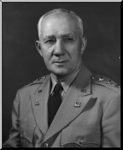
Lieutenant General Lewis Andrew Pick was a United States Army officer who served as Chief of Engineers in the United States Army.

Gavins Point Dam is a 1.9 mi (3 km) long embankment rolled-earth and chalk-fill dam which spans the Missouri River and impounds Lewis and Clark Lake. The dam joins Cedar County, Nebraska with Yankton County, South Dakota a distance of 811.1 river miles (1,305 km) upstream of St. Louis, Missouri, where the river joins the Mississippi River. The dam and hydroelectric power plant were constructed as the Gavins Point Project from 1952 to 1957 by the United States Army Corps of Engineers as part of the Pick-Sloan Plan. The dam is located approximately 4 miles (6.4 km) west or upstream of Yankton, South Dakota.

Metro Lakeland is a name that was coined in the 1960s for an area of southern Illinois that is centered on the intersections of Interstate 57, Interstate 24, and Illinois Route 13 — a four-lane east-west highway connecting the communities of Murphysboro, Carbondale, Carterville, Herrin, Marion, and Harrisburg. Metro Lakeland was defined as Jackson, Williamson, Franklin, Saline, and Perry counties, with a combined population of approximately 210,000. Carbondale, Herrin, and Marion are the key urban areas, with a combined city-proper population of over 65,000 Carbondale, the site of Southern Illinois University, is the region's largest city. Metro Lakeland is about 88 miles (142 km) southeast of St. Louis, Missouri, or 120 miles (190 km) by Interstate highway.

Yellowtail Dam is a dam across the Bighorn River in south central Montana in the United States. The mid-1960s era concrete arch dam serves to regulate the flow of the Bighorn for irrigation purposes and to generate hydroelectric power. The dam and its reservoir, Bighorn Lake, are owned by the U.S. Bureau of Reclamation.

Kenneth James Gray was an American businessman and politician. He was a veteran of World War II, and represented Illinois in the United States House of Representatives from 1955 to 1974, and again from 1985 to 1989.
William Glenn Sloan was an American inventor and scientist who was co-author of Pick-Sloan Missouri Basin Program to dam the upper Missouri River.
The Water Resources Development Act of 1999, Pub. L. 106–53 (text)(PDF), was enacted by Congress of the United States on August 17, 1999. Most of the provisions of WRDA 1999 are administered by the United States Army Corps of Engineers.

The Susquehanna River Basin Commission (SRBC) is a federal-interstate compact commission created by the Susquehanna River Basin Compact between three U.S states:, and the federal government, and signed into law by President Richard Nixon on Christmas Eve 1970 to be effective 30 days later on January 23, 1971.

Sheila J. Simon is an American politician who served as the 46th Lieutenant Governor of Illinois, from 2011 to 2015. In 2014, she was the Democratic nominee for Illinois State Comptroller, losing to Republican incumbent Judy Baar Topinka. Simon is the daughter of former U.S. Senator Paul Simon, who had previously served as Lieutenant Governor of Illinois (1969–1973), and his first wife, former Illinois State Representative Jeanne Hurley Simon.

Shadehill Dam is a dam on the Grand River in Perkins County in northwestern South Dakota in the United States, about 10 miles (16 km) south of Lemmon. The dam and its impoundment, Shadehill Reservoir, serve mainly for flood and silt control, wildlife conservation and recreation. Located directly below the confluence of the North and South Forks of the Grand River, the dam is operated by the U.S. Bureau of Reclamation, and is part of the Shadehill Unit of the Pick-Sloan Missouri Basin Program.
References
- 1 2 "Former SIU teacher dies" (PDF). The Daily Egyptian. Southern Illinois University Carbondale. 17 February 1982. Retrieved 20 December 2020.
- 1 2 3 4 5 6 7 8 Landecker, Manfred (1982). "In memoriam: Marian Elizabeth Ridgeway". PS: Political Science & Politics . 15 (3): 13. doi:10.1017/S1049096500060686.
- 1 2 Rice, Ross R. (1 December 1956). "Review The Missouri Basin's Pick-Sloan Plan: A Case Study in Congressional Policy Determination". The Western Political Quarterly. 9 (4): 1011–1012. doi:10.2307/444524. JSTOR 444524.
- ↑ Geological Survey Water-supply Paper. United States Geological Survey. 1962. p. 161.
- ↑ Davidson, John H. Allocation water uses of the Missouri River: The search for legal process. University of South Dakota. p. 3.
- ↑ Commission on Organization of the Executive Branch of the Government (Water Resources and Power Report). United States Congress. 1955. p. 1929.