Related Research Articles

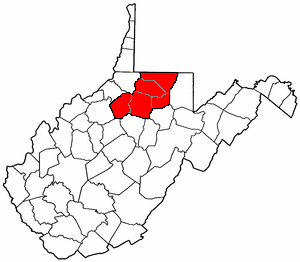
Marion County is a county in the U.S. state of West Virginia. As of the 2010 census, the population was 56,418. Its county seat is Fairmont. The county was named in honor of General Francis Marion, known to history as "The Swamp Fox".

Fairmont is a city in Marion County, West Virginia, United States. The population was 18,704 at the 2010 census. It is the county seat of Marion County.

Monongah is a town in Marion County, West Virginia, USA, situated where Booths Creek flows into the West Fork River. The population was 1,044 at the 2010 census. Monongah was chartered in 1891 based on Chapter 47 of West Virginia code. Its name is derived from the nearby Monongahela River.

Pleasant Valley is a city in Marion County, West Virginia, United States. The population was 3,149 at the 2010 census.

Rivesville is a town and former coal town in Marion County, West Virginia, United States. The population was 934 at the 2010 census.

The Monongahela River —often referred to locally as the Mon —is a 130-mile-long (210 km) river on the Allegheny Plateau in north-central West Virginia and southwestern Pennsylvania. The river flows from the confluence of its west and east forks in north-central West Virginia northeasterly into southwestern Pennsylvania, then northerly to Pittsburgh and its confluence with the Allegheny River to form the Ohio River. The river's entire length is navigable via a series of locks and dams.

A hairpin turn is a bend in a road with a very acute inner angle, making it necessary for an oncoming vehicle to turn about 180° to continue on the road. It is named for its resemblance to a bent metal hairpin. Such turns in ramps and trails may be called switchbacks in American English, by analogy with switchback railways. In British English "switchback" is more likely to refer to a heavily undulating road—a use extended from the rollercoaster and the other type of switchback railway.

The West Fork River is a principal tributary of the Monongahela River, 103-mile (166 km) long, in north-central West Virginia, United States. Via the Monongahela and Ohio Rivers, it is part of the watershed of the Mississippi River, draining an area of 881 square miles (2,284 km²) on the unglaciated portion of the Allegheny Plateau.

Blue Ridge Mountain, also known as Blue Mountain, is the colloquial name of the westernmost ridge of the Blue Ridge Mountains in northern Virginia and the Eastern Panhandle of West Virginia. The Appalachian Trail traverses the entire length of the mountain along its western slope and crest.

The Greenbrier River Trail (GRT), is a lineal state park comprising a 77.1-mile (124.1 km) rail trail between North Caldwell and Cass in eastern West Virginia.
North Central West Virginia is a region of the U.S. State of West Virginia. The region's largest city is Morgantown.

Prickett's Fort State Park is a 188-acre (76.1 ha) West Virginia state park north of Fairmont, near the confluence of Prickett's Creek and the Monongahela River. The park features a reconstructed refuge fort and commemorates life on the Virginia frontier during the late 18th century.
The Mon River Trail is a rail trail located in West Virginia, United States.
The Caperton River Trail is a rail trail located in West Virginia, United States.
The Deckers Creek Trail is a rail trail located in West Virginia.
New River Trail State Park is a 57.7-mile (92.9 km) rail trail and state park located entirely in southwest Virginia, extending from the trail's northeastern terminus in Pulaski to its southern terminus in Galax, with a 5.5-mile (8.9 km) spur from Fries Junction on the main trail to Fries.
Low Level Bridge is the nickname of a bridge that was in Fairmont, West Virginia.

Pierpont Community and Technical College (Pierpont) is a public community college in Fairmont, West Virginia. Founded in 1974, it has the second largest enrollment of the 10 Community and Technical Colleges that make up the West Virginia Community and Technical College System. The college serves 13 counties in North Central West Virginia with classes offered at more than 15 locations throughout the region. Its headquarters is located in Fairmont, West Virginia. The student/faculty ratio is 17:1.
The Sheepskin Trail is a non-motorized rail-trail in Fayette County, Pennsylvania. It is planned to eventually link the Great Allegheny Passage trail system near Dunbar to the Mon River Trail system at the Pennsylvania/West Virginia state line near Point Marion. Currently, due to funding restrictions, the trail is only opened for 2.1 miles (3.4 km) from the Great Allegheny Passage junction to the Dunbar town center, where there is parking and a comfort station available for public use.
References
- ↑ "MCTrail and the Meredith Tunnel". MCPARC (Marion County Parks and Recreation Commission). 2009. Archived from the original on February 7, 2012.