
Marions bank is an islet in Palmerston Island in the Cook Islands. It is on the north side of the atoll, between Tara i tokerau and Motu Ngangie. The islet is named after one of the first people born on Palmerston. [1]
Marions bank is an islet in Palmerston Island in the Cook Islands. It is on the north side of the atoll, between Tara i tokerau and Motu Ngangie. The islet is named after one of the first people born on Palmerston. [1]

The Coral Sea Islands Territory is an external territory of Australia which comprises a group of small and mostly uninhabited tropical islands and reefs in the Coral Sea, north-east of Queensland, Australia. The only inhabited island is Willis Island. The territory covers 780,000 km2 (301,160 sq mi), most of which is ocean, extending east and south from the outer edge of the Great Barrier Reef and includes Heralds Beacon Island, Osprey Reef, the Willis Group and fifteen other reef/island groups. Cato Island is the highest point in the Territory.

The Balleny Islands are a series of uninhabited islands in the Southern Ocean extending from 66°15' to 67°35'S and 162°30' to 165°00'E. The group extends for about 160 km (99 mi) in a northwest–southeast direction. The islands are heavily glaciated and of volcanic origin. Glaciers project from their slopes into the sea. The islands were formed by the so-called Balleny hotspot.
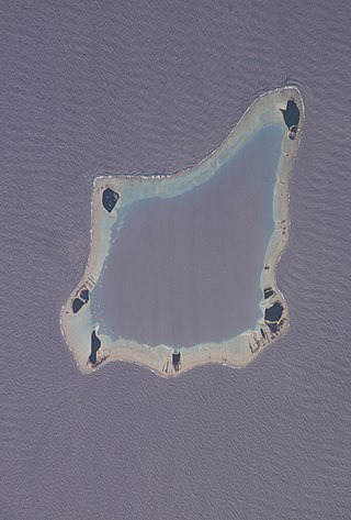
Palmerston Island is a coral atoll in the Cook Islands in the Pacific Ocean about 290 miles (470 km) northwest of Rarotonga. James Cook landed there on 16 June 1774.

Boundary Islet, historically known as North East Islet, is a 2-hectare (4.9-acre) islet in the Hogan Island Group of Bass Strait, at a latitude of 39°12′ S, about 56 kilometres (35 mi) east of the southernmost point of mainland Victoria. The islet straddles the maritime border of the Australian states of Victoria and Tasmania, hence the name.

The Elaphiti Islands or the Elaphites is a small archipelago consisting of several islands stretching northwest of Dubrovnik, in the Adriatic Sea. The Elaphites have a total land area of around 30 square kilometres and a population of 850 inhabitants. The islands are covered with characteristic Mediterranean evergreen vegetation and attract large numbers of tourists during the summer tourist season due to their beaches and pristine scenery.

The Liancourt Rocks, known in Korea as Dokdo and in Japan as Takeshima, are a group of islets in the Sea of Japan between the Korean Peninsula and the Japanese archipelago administered by South Korea. The Liancourt Rocks comprise two main islets and 35 smaller rocks; the total surface area of the islets is 0.187554 square kilometres and the highest elevation of 168.5 metres (553 ft) is on the West Islet. The Liancourt Rocks lie in rich fishing grounds that may contain large deposits of natural gas. The English name Liancourt Rocks is derived from Le Liancourt, the name of a French whaling ship that came close to being wrecked on the rocks in 1849.

Telish Rock is the islet off the south coast of Livingston Island in the South Shetland Islands, Antarctica situated 400 m (437 yd) south of Elephant Point and 3 km (1.86 mi) northwest by west of Enchantress Rocks. Extending 300 by 180 m. The area was visited by early 19th century sealers.
Guépratte Island is an ice-covered island 2.8 km (1.7 mi) long, lying between Anvers Island and Brabant Island at the east side of the entrance to Fournier Bay, in the Palmer Archipelago, Antarctica. The island was first shown on the Ludwig Friederichsen map of 1895, embodying the 1873–74 explorations of a German expedition under Eduard Dallmann. It was later charted by the French Antarctic Expedition, 1903–05, under Jean-Baptiste Charcot, who named it after Captain Guépratte of the French Navy. The name "Discovery Island", applied in 1927 by Discovery Investigations personnel on the Discovery, has been rejected in favour of the earlier name.

Home is an islet in Palmerston Island in the Cook Islands. Sometimes referred to as Palmerston or Pamati, the name given to the atoll by James Cook, it is the only inhabited islet in the atoll. It is on the west side of the atoll, between Cooks and North Island.
North Island is an islet in Palmerston Island in the Cook Islands. The islet's name is a simple physical description. it is at the northern tip of the atoll, between Home and Tara i tokerau.
Tara i tokerau is an islet in Palmerston Island in the Cook Islands. The islet is on the north tip of the atoll, between North Island and Marions bank.
Motu Ngangie is an islet in Palmerston Island in the Cook Islands. it is on the eastern side of the atoll, between Marions bank and Lee To Us. The island is named after the ngangie plant.
Lee To Us is an islet in Palmerston Island in the Cook Islands. The island is on the east side of the atoll, between Motu Ngangie and Leicester. Its name is a simple physical description.
Leicester is an islet in Palmerston Island in the Cook Islands. It is on the east side of the atoll, between Lee To Us and Small Cooks. It is named after William Marsters' probable birthplace of Leicester.
Small Cooks is an islet in Palmerston Island in the Cook Islands. It is on the eastern side of the atoll, between Leicester and Karakerake. Its name is a reference to Cooks, another islet on the atoll.
Karakerake is an islet in Palmerston Island in the Cook Islands. it is on the eastern edge of the atoll, between Small Cooks and Primrose. It is named after the family land of Akakaingara, one of William Marsters' three wives, on Penrhyn atoll.
Primrose is an islet in Palmerston Island in the Cook Islands. It is on the southeastern edge of the atoll, between Karakerake and Toms. The islet is named after a ship which was wrecked there.
Toms is an islet in Palmerston Island in the Cook Islands. It is at the southern tip of the atoll, between Primrose and Cooks. The island is named after someone from Palmerston's history.
Cooks is an islet in Palmerston Island in the Cook Islands. It is on the southern edge of the atoll, between Toms and Home. The islet is named after James Cook.
17°59′55.12″S163°9′25.73″W / 17.9986444°S 163.1571472°W
| | This article about an island in the Cook Islands is a stub. You can help Wikipedia by expanding it. |