Markoye | |
---|---|
Department | |
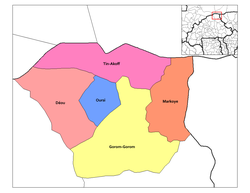
Markoye Department location in the province | |
Country | |
Province | Oudalan Province |
Time zone | GMT 0 (UTC+0) |
Markoye is a department or commune of Oudalan Province in northern Burkina Faso. Its capital lies at the town of Markoye. [1]
The provinces of Burkina Faso are divided into 351 departments, whose urbanized areas are grouped into the same commune (municipality) with the same name as the department. The 351 communes created in those departments have three kinds of status :
Oudalan is one of the 45 provinces of Burkina Faso, located in its Sahel Region. Its capital is Gorom-Gorom. The 2006 census reported 197,240 people living in the province.
Burkina Faso is a landlocked country in West Africa. It covers an area of around 274,200 square kilometres (105,900 sq mi) and is surrounded by six countries: Mali to the north; Niger to the east; Benin to the southeast; Togo and Ghana to the south; and Ivory Coast to the southwest. The July 2018 population estimate by the United Nations was 19,751,651. Burkina Faso is a francophone country, with French as the official language of government and business. Roughly 40% of the population speaks the Mossi language. Formerly called the Republic of Upper Volta (1958–1984), the country was renamed "Burkina Faso" on 4 August 1984 by then-President Thomas Sankara. Its citizens are known as Burkinabé. Its capital is Ouagadougou.
This section is empty.You can help by adding to it.(July 2010) |
Řečany nad Labem is a village in the Pardubice Region of the Czech Republic. It has around 1,350 inhabitants.
Ostřetín is a village in the Pardubice Region of the Czech Republic. It has around 950 inhabitants.
Taqah is a coastal town in the Dhofar governorate, in southwestern Oman. It is located at about 17°2′14″N54°24′13″E.
The Northern Great Plain is a statistical region of Hungary. It is part of the Great Plain and North region. The Northern Great Plain includes the counties of Hajdú-Bihar, Jász-Nagykun-Szolnok, and Szabolcs-Szatmár-Bereg, with a total area of 17,749 km2 (6,853 sq mi) and a population of around 1.5 million.
Kot Sarang is a village and union council of Pakistan, an administrative subdivision, of the Chakwal District in the Punjab Province of Pakistan, it is part of Talagang Tehsil. The Sawan River and the village of Jisial are nearby.
Mikoszów is a village in the administrative district of Gmina Strzelin, within Strzelin County, Lower Silesian Voivodeship, in south-western Poland. Prior to 1945 it was in Germany.
Markoye is a department or commune of Oudalan Province in northern Burkina Faso. Its capital lies at the town of Markoye.
Owsianka is a settlement in the administrative district of Gmina Czarna Dąbrówka, within Bytów County, Pomeranian Voivodeship, in northern Poland. It lies approximately 9 kilometres (6 mi) north-east of Czarna Dąbrówka, 33 km (21 mi) north of Bytów, and 65 km (40 mi) west of the regional capital Gdańsk.
Alıkeyxalı is a village in the Jabrayil Rayon of Azerbaijan.
Armudlu is a village in the Qakh Rayon of Azerbaijan. The village forms part of the municipality of Qaşqaçay.
Fərzəlioba is a village in the Khachmaz Rayon of Azerbaijan. The village forms part of the municipality of İdrisoba.
Sulborowice is a village in the administrative district of Gmina Fałków, within Końskie County, Świętokrzyskie Voivodeship, in south-central Poland. It lies approximately 8 kilometres (5 mi) north-west of Fałków, 27 km (17 mi) west of Końskie, and 54 km (34 mi) north-west of the regional capital Kielce.
Lipczyno is a settlement in Gmina Miastko, Bytów County, Pomeranian Voivodeship, in northern Poland. It lies approximately 36 kilometres (22 mi) south-west of Bytów and 113 km (70 mi) south-west of Gdańsk.
Buszkowo is a settlement in the administrative district of Gmina Debrzno, within Człuchów County, Pomeranian Voivodeship, in northern Poland. It lies approximately 14 kilometres (9 mi) west of Debrzno, 25 km (16 mi) south-west of Człuchów, and 138 km (86 mi) south-west of the regional capital Gdańsk.
Chomętowo is a village in the administrative district of Gmina Trzebiatów, within Gryfice County, West Pomeranian Voivodeship, in north-western Poland. It lies approximately 8 kilometres (5 mi) west of Trzebiatów, 14 km (9 mi) north of Gryfice, and 80 km (50 mi) north-east of the regional capital Szczecin.
Yangmok Station is a railway station on the Gyeongbu Line, the most important railway line in South Korea and one of the oldest. It is located between Waegwan Station and Gumi Station.
Puka is a village in Saaremaa Parish, Saare County in western Estonia.
Damanhour University is located in Damanhour Egypt. It was established in 2010.
Belogorka, also known as Belogorskiy, is a town in Aktobe Region, west Kazakhstan. It lies at an altitude of 340 m (1,120 ft).
Coordinates: 14°38′21″N0°02′14″E / 14.63917°N 0.03722°E
A geographic coordinate system is a coordinate system that enables every location on Earth to be specified by a set of numbers, letters or symbols. The coordinates are often chosen such that one of the numbers represents a vertical position and two or three of the numbers represent a horizontal position; alternatively, a geographic position may be expressed in a combined three-dimensional Cartesian vector. A common choice of coordinates is latitude, longitude and elevation. To specify a location on a plane requires a map projection.
This Oudalan Province location article is a stub. You can help Wikipedia by expanding it. |