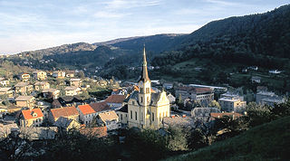
Hrastnik is a town in the Central Sava Valley in central Slovenia. It is the seat of the Municipality of Hrastnik. Traditionally the area was part of the Styria region. The entire municipality is now included in the Central Sava Statistical Region. The town has its own library and school.

Medlog is a settlement in the City Municipality of Celje in eastern Slovenia. It lies on the western outskirts of Celje. The grass runway of Celje Airport is located in the western part of the settlement. The area was traditionally part of the Styria region. It is now included with the rest of the municipality in the Savinja Statistical Region.
Bukovžlak is a settlement in the City Municipality of Celje in eastern Slovenia. It lies on the eastern outskirts of Celje, just north of Teharje. The area was traditionally part of the Styria region. It is now included with the rest of the municipality in the Savinja Statistical Region.
Mošnje is a village in the Municipality of Radovljica in the Upper Carniola region of Slovenia.
Harije is a village in the hills west of Ilirska Bistrica in the Inner Carniola region of Slovenia.

Jelšane is a village in the Municipality of Ilirska Bistrica in the Inner Carniola region of Slovenia, right on the border with Croatia. The Jelšane international border crossing between Slovenia and Croatia is just south of the village.
Trnovec is a settlement in the hills northeast of the town of Kočevje in southern Slovenia. It was a village inhabited by Gottschee Germans. At the start of the Second World War its original population was evicted. The area is part of the traditional region of Lower Carniola and is now included in the Southeast Slovenia Statistical Region.

Pance is a settlement in the hills north of Grosuplje in central Slovenia. It belongs to the City Municipality of Ljubljana. Traditionally the area was part of Lower Carniola. It is now included with the rest of the municipality in the Central Slovenia Statistical Region.

Selo pri Pancah is a small settlement in the City Municipality of Ljubljana in central Slovenia. It lies in the hills southwest of the capital Ljubljana. The area was part of the traditional region of Lower Carniola and is now included with the rest of the municipality in the Central Slovenia Statistical Region.

Ravenska Vas is a settlement immediately east and southeast of Zagorje ob Savi in central Slovenia. The area is part of the traditional region of Upper Carniola. It is now included with the rest of the municipality in the Central Sava Statistical Region.

Knezdol is a settlement in the Municipality of Trbovlje in central Slovenia. It is made up of clusters of settlement and isolated farmsteads dispersed though the hills north of the town of Trbovlje. Traditionally the area was part of the Styria region. It is now included with the rest of the municipality in the Central Sava Statistical Region.

Kal is a settlement in the Municipality of Hrastnik in central Slovenia. It lies in the hills north of Dol pri Hrastniku. Traditionally the area was part of the Styria region. It is now included with the rest of the municipality in the Central Sava Statistical Region. Kal includes the hamlets of Spodnji Kal and Veliki Kal.

Podkraj is a settlement in the Municipality of Hrastnik in central Slovenia. It lies on the right bank of the Sava River. Traditionally the area was part of the Lower Carniola region. It is now included with the rest of the municipality in the Central Sava Statistical Region. It includes the hamlets of Sava, Koritnik, Strušce, Kladje, Ruda, Boriče, and Hribar.
Pongrac is a settlement in the Municipality of Žalec in east-central Slovenia. It lies in the hills south of Žalec. The area is part of the traditional region of Styria. The municipality is now included in the Savinja Statistical Region.

Marija Reka is a settlement in the Municipality of Prebold in east-central Slovenia. It lies in the hills south of Prebold. The area is part of the traditional region of Styria. The municipality is now included in the Savinja Statistical Region. The settlement includes the hamlets of Mala Reka, Velika Reka, and Jelenca.
Novo Tepanje is a settlement in the Municipality of Slovenske Konjice in eastern Slovenia. It lies on the regional road from Slovenske Konjice to Slovenska Bistrica on the left bank of Oplotnica Creek, a left tributary of the Dravinja River. The area is part of the traditional region of Styria. The municipality is now included in the Savinja Statistical Region.
Cerovec pri Šmarju is a dispersed settlement in the Municipality of Šmarje pri Jelšah in eastern Slovenia. It lies in the Kozje region in the hills to the south of Šmarje pri Jelšah. The area is part of the traditional region of Styria. The municipality is now included in the Savinja Statistical Region.
Breg is a settlement on the left bank of the Sava River in the Municipality of Sevnica in central Slovenia. The area is part of the historical region of Styria. The municipality is now included in the Lower Sava Statistical Region. The settlement includes the hamlets of Gradišče, Jelše, and Zagradec.
Pečje is a settlement in the Municipality of Sevnica in central Slovenia. It lies just east of Sevnica above the left bank of the Sava River The area is part of the historical region of Styria. The municipality is now included in the Lower Sava Statistical Region.