
Davis County is a county located in the U.S. state of Iowa. As of the 2020 census, the population was 9,110. The county seat is Bloomfield.

Odessa is a town in New Castle County, Delaware, United States. The population was 364 at the 2010 census. Founded as Cantwell's Bridge in the 18th century, the name was changed in the 19th century, after the Ukrainian port city of the same name. Today a significant part of the town is a historic district list on the National Register of Historic Places.

North Boston is a hamlet and census-designated place (CDP) in the town of Boston in Erie County, New York, United States. As of the 2010 census, the CDP population was 2,521. It is part of the Buffalo–Niagara Falls Metropolitan Statistical Area.

Ramseur is a town in Randolph County, North Carolina, United States. The population was 1,692 at the 2010 census.

Snake Spring Township is a township in Bedford County, Pennsylvania, United States. The population was 1,771 at the 2020 census.

Jackson Township is an American township that is located in Dauphin County, Pennsylvania. The population was 1,830 at the time of the 2020 census, a decline from the figure of 1,941 tabulated in 2010.

Hanson is a census-designated place (CDP) in the town of Hanson in Plymouth County, Massachusetts, United States. The population was 2,118 at the 2010 census.

Warren is a census-designated place (CDP) in the town of Warren in Worcester County, Massachusetts, United States. The population was 1,405 at the 2010 census.
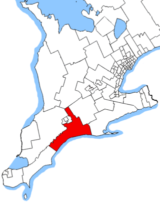
Elgin—Middlesex—London is a federal electoral district in Ontario, Canada, that has been represented in the House of Commons of Canada since 1997.
Mahuakhera Ganj is a City, a Nagar Palika Parishad in Udham Singh Nagar district in the Indian state of Uttarakhand. The Mahuakhera Ganj city is divided into 9 wards for which elections are held every 5 years.
Oakville, Manitoba is an unincorporated community recognized as a local urban district in Manitoba. It is located in the Rural Municipality of Portage la Prairie. Oakville is 56 km (35 mi) west of Winnipeg at the intersection of PTH 13 and PR 331.
Narasingapuram is a Municipality in Attur taluk, Salem district in the Indian state of Tamil Nadu. As of 2011, the town had a population of 23,084.
Dawo is one of the Aanaas in the Oromia of Ethiopia. Part of the Southwest Shewa Zone, Dawo is bordered on the southwest by Waliso, on the west and north by Dendi, on the east by Elu, and on the southeast by Becho. The major town in Dawo is Busa.
Tulo is one of the Aanaas in Oromia Regional State of Ethiopia. Part of the West Hararghe Zone, Tulo is bordered on to the north by Doba, to the south by Masela, to the east by the East haraghe Zone, and to the west by Nannawa Chiro. Towns in Tulo include Debeso and Hirna.
Giddaluru is a town in the Prakasam district of the Indian state of Andhra Pradesh. It is the mandal headquarters of the Giddaluru mandal in Markapur revenue division. It was part of kurnool district till 1969 later it was merged into Prakasam district in 1970. Till 2008 it was under Nandyal parliament segment after delimitation it was moved to Ongole MP segment. Giddalur is also known as "3 zilla la muddu bidda " because during the Britishers rule it was in kadapa district later moved to kurnool then in 1970 merged in prakasam district. Giddalur is the only constituency in coastal districts which has Rayalseema culture,slang and traditions. Giddalur town has good transport connectivity to Nandyal, Markapur, Podili, Ongole, Kurnool, Kadapa.
Marripadu is a village and a Mandal in Nellore district in the state of Andhra Pradesh in India. It is located at the border of Nellore District. It produces tobacco. It is on the banks of small river called Boggeru. Somasila Project, Udayagiri are the adjacent tourist places.
The 1920 U.S. Open was the 24th U.S. Open, held August 12–13 at the Inverness Club in Toledo, Ohio.

Clearwater 175 is an Indian reserve of the Fort McMurray First Nation in Alberta, located within the Regional Municipality of Wood Buffalo. It is 7 kilometers southeast of Fort McMurray.
Nigadi is a village in Dharwad district of Karnataka, India.

Pilisvörösvár is a district in north-western part of Pest County. Pilisvörösvár is also the name of the town where the district seat is found. The district is located in the Central Hungary Statistical Region.

