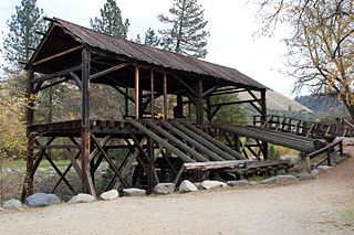
Sutter's Mill was a water-powered sawmill on the bank of the South Fork American River in the foothills of the Sierra Nevada in California. It was named after its owner John Sutter. A worker constructing the mill, James W. Marshall, found gold there in 1848. This discovery set off the California Gold Rush (1848–1855), a major event in the history of the United States.

Sutter's Fort was a 19th-century agricultural and trade colony in the Mexican Alta California province. Established in 1839, the site of the fort was originally called New Helvetia by its builder John Sutter, though construction of the fort proper would not begin until 1841. The fort was the first non-indigenous community in the California Central Valley. The fort is famous for its association with the Donner Party, the California Gold Rush, and the formation of the city of Sacramento, surrounding the fort. It is notable for its proximity to the end of the California Trail and Siskiyou Trails, which it served as a waystation.

Amador County is a county located in the U.S. state of California, in the Sierra Nevada. As of the 2020 census, the population was 40,474. The county seat is Jackson. Amador County, located within California's Gold Country, is known as "The Heart of the Mother Lode". There is a substantial viticultural industry in the county.

El Dorado County, officially the County of El Dorado, is a county located in the U.S. state of California. As of the 2020 census, the population was 191,185. The county seat is Placerville. The county is part of the Sacramento-Roseville-Arden-Arcade, CA Metropolitan Statistical Area. It is located entirely in the Sierra Nevada, from the historic Gold Country in the western foothills to the High Sierra in the east. El Dorado County's population has grown as Greater Sacramento has expanded into the region. Where the county line crosses US 50 at Clarksville, the distance to Sacramento is 15 miles. In the county's high altitude eastern end at Lake Tahoe, environmental awareness and environmental protection initiatives have grown along with the population since the 1960 Winter Olympics, hosted at the former Squaw Valley Ski Resort in neighboring Placer County.

Placerville is a city in and the county seat of El Dorado County, California. The population was 10,747 as of the 2020 census, up from 10,389 as of the 2010 census. It is part of the Sacramento–Arden-Arcade–Roseville Metropolitan Statistical Area.
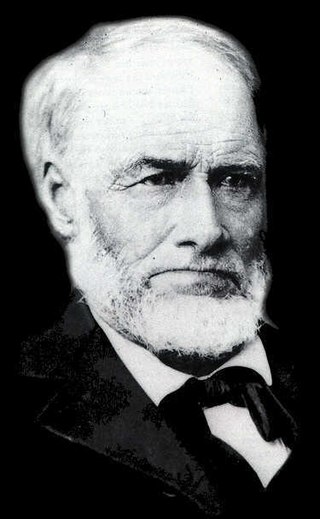
James Wilson Marshall was an American carpenter and sawmill operator, who on January 24, 1848 reported the finding of gold at Coloma, California, a small settlement on the American River about 36 miles northeast of Sacramento. His discovery was the impetus for the California Gold Rush. The mill property was owned by Johann (John) Sutter who employed Marshall to build his mill. The wave of gold seekers turned everyone's attention away from the mill which eventually fell into disrepair and was never used as intended. Neither Marshall nor Sutter ever profited from the gold find.

The Native Sons of the Golden West is a fraternal service organization founded in the U.S. state of California in 1875, dedicated to historic preservation and documentation of the state's historic structures and places, the placement of historic plaques, and other charitable functions in California. In 1890 they placed California's first marker honoring the discovery of gold, which gave rise to the state nickname "The Golden State". U.S. President Richard M. Nixon and Chief Justice Earl Warren were NSGW presidents.

The Gold Country is a historic region in the northern portion of the U.S. state of California, that is primarily on the western slope of the Sierra Nevada. It is famed for the mineral deposits and gold mines that attracted waves of immigrants, known as the 49ers, during the 1849 California Gold Rush.

Virginia City is a census-designated place (CDP) that is the county seat of Storey County, Nevada, and the largest community in the county. The city is a part of the Reno–Sparks Metropolitan Statistical Area.
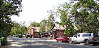
Coloma is a census-designated place in El Dorado County, California, US. It is approximately 36 miles (58 km) northeast of Sacramento, California. Coloma is most noted for being the site where James W. Marshall found gold in the Sierra Nevada foothills, at Sutter's Mill on January 24, 1848, leading to the California Gold Rush. Coloma's population is 529.

State Route 49 is a north–south state highway in the U.S. state of California that passes through many historic mining communities of the 1849 California gold rush and it is known as the Golden Chain Highway. The highway's creation was lobbied by the Mother Lode Highway Association, a group of locals and historians seeking a single highway to connect many relevant locations along the Gold Rush to honor the 49ers. One of the bridges along SR 49 is named for the leader of the association, Archie Stevenot.

A California Historical Landmark (CHL) is a building, structure, site, or place in the U.S. state of California that has been determined to have statewide historical landmark significance.

Marshall Gold Discovery State Historic Park is a state park of California, United States, marking the discovery of gold by James W. Marshall at Sutter's Mill in 1848, sparking the California Gold Rush. The park grounds include much of the historic town of Coloma, California, which is now considered a ghost town as well as a National Historic Landmark District. The park contains thre California Historical Landmarks: a monument to commemorate James Marshall (#143), the actual spot where he first discovered gold in 1848 (#530). Established in 1942, and Coloma Road (#748),. The park now comprises 576 acres (233 ha) in El Dorado County.

Plumas-Eureka State Park is a California state park located in the Sierra Nevada and Cascade Range in Plumas County, California.
Belleville, California was a gold mining boomtown in the San Bernardino Mountains of San Bernardino County, California. The settlement grew up rapidly following the discovery of gold by William F. Holcomb in Holcomb Valley early 1860. Which helped the town challenge the seat of San Bernardino County. Belleville was named after Belle, the first child born in the new town. It was a busy mining town for ten years, it was virtually abandoned before the end of the 19th century. It is now a ghost town.

El Dorado Canyon is a canyon in southern Clark County, Nevada famed for its rich silver and gold mines. The canyon was named in 1857 by steamboat entrepreneur Captain George Alonzo Johnson when gold and silver was discovered here. It drains into the Colorado River at the former site of Nelson's Landing.

Swansboro Country; a subdivision within the community of Mosquito, is a residential area northeast of Placerville, the county seat of El Dorado County, California. The population was approximately 1,000 at the 2010 census. It is part of the Sacramento–Arden-Arcade–Roseville Metropolitan Statistical Area.

The case of Woodruff v. North Bloomfield Gravel Mining Company was a lawsuit brought to California courts in 1882 where a group of local farmers sued North Bloomfield Mining and Gravel Company over damages caused to farmland in the Central Valley. The farmers who brought the suit claimed that the company's hydraulic mining operations resulted in the disposal of excess sediment, debris, and chemicals in local rivers. Prosecutors argued that the debris raised river beds and restricted flow in the rivers leading to heavy man-made flooding. In the years prior, flooding of debris and chemicals had destroyed a large portion of the valley's agriculture.
Coloma Road in Rescue, California is a historical road in Contra Costa County. A Historical Landmark was built at 4222 Green Valley Road in Rescue, California at the Rescue Junction General Store. The old Coloma Road opened in 1847, it ran from Sutter's Fort to the city of Coloma. James W. Marshall traveled the road to tell of his gold find to Captain John A. Sutter. During the 49ers miners gold rush thousands of miners traveled the road heading out to look for gold and claims. California's first stage line, California Stage Company, traveled the road starting in 1849, the line was founded by James E. Birch.

