
Sandsfoot Castle, also known historically as Weymouth Castle, is an artillery fort constructed by Henry VIII near Weymouth, Dorset. It formed part of the King's Device programme to protect against invasion from France and the Holy Roman Empire, and defended the Weymouth Bay anchorage. The stone castle had an octagonal gun platform, linked to a residential blockhouse, and was completed by 1542 at a cost of £3,887. Earthwork defences were built around the landward side of the castle, probably in 1623. Sandsfoot saw service during the English Civil War, when it was held by Parliament and Royalists in turn during the conflict. It survived the interregnum but, following Charles II's restoration to the throne, the fortress was withdrawn from military use in 1665.

Hod Hill is a large hill fort in the Blackmore Vale, 3 miles (5 km) north-west of Blandford Forum, Dorset, England. The fort sits on a 143 m (469 ft) chalk hill of the same name that lies between the adjacent Dorset Downs and Cranborne Chase. The hill fort at Hambledon Hill is just to the north. The name probably comes from Old English "hod", meaning a shelter, though "hod" could also mean "hood", referring to the shape of the hill.
Scargill is a hamlet in the Pennines of England, situated close to the River Greta. The population taken at the 2011 Census was less than 100. Details are kept in the parish of Barningham. It lies within the historic boundaries of the North Riding of Yorkshire, but along with the rest of the former Startforth Rural District it was transferred to County Durham for administrative and ceremonial purposes on 1 April 1974, under the provisions of the Local Government Act 1972.

Wakeham is a hamlet near the village of Easton, in Tophill on the Isle of Portland in Dorset, England. It is situated between the Straits part of Easton, and Pennsylvania Castle. As with the rest of Portland's villages and settlements, Wakeham has been designated as a conservation area, as it is a place of special architectural and historic interest. Easton, Wakeham and Reforne were designated pre-1974. The hamlet features a distinctively wide road running through it, once built to allow space for horse-drawn carts transporting stone by road. Many of Wakeham's older buildings of the 17th and 18th century survive.
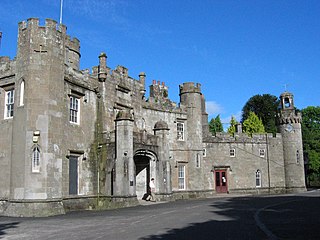
Balloch Castle is an early 19th-century country house situated at the southern tip of Loch Lomond, in West Dunbartonshire, Scotland. Balloch was a property of the Lennox family from the 11th century, and the old castle was built in the 13th century. In the 19th century the estate was purchased by John Buchanan of Ardoch, who demolished the ruins of the old castle and erected the present building. The Tudor Gothic architecture is the work of Robert Lugar. In 1915 Balloch was bought by Glasgow City Corporation, and has been leased by West Dunbartonshire Council since 1975. The estate was designated as a country park in 1980, and since 2002 has been part of Loch Lomond and The Trossachs National Park. Although the house has been periodically used for visitor facilities and council offices, it is now included on the Buildings at Risk Register. Balloch Castle is a category A listed building, and the estate is included on the Inventory of Gardens and Designed Landscapes in Scotland.

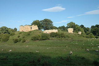
Gleaston Castle is a medieval building in a valley about 1 kilometre (0.62 mi) north-east of the village of Gleaston. The village lies between the towns of Ulverston and Barrow-in-Furness in the Furness peninsula, Cumbria, England. Gleaston Castle has a quadrilateral plan, with a tower at each corner. The largest of these, the north-west tower, probably housed a hall.
Mitford Castle is an English castle dating from the end of the 11th century and located at Mitford, Northumberland. It is a Scheduled Ancient Monument and a Grade I listed building, enlisted on 20 October 1969. The castle is also officially on the Buildings at Risk Register. The Norman motte and bailey castle stands on a small prominence, a somewhat elliptical mound, above the River Wansbeck. The selected building site allowed for the natural hill to be scarped and ditched, producing the motte.

While there are many castles in South Yorkshire, the majority are manor houses and motte-and-bailey which were commonly found in England after the Norman Conquest.
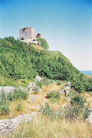
Rufus Castle, also known as Bow and Arrow Castle, is a partially ruined castle overlooking Church Ope Cove on Portland, England. Its name derives from King William II, known as William Rufus, for whom the original castle was built.
Bury Castle is an Iron Age hillfort near Selworthy, Somerset, England. It has been designated as a scheduled monument.

Corfe Castle is a fortification standing above the village of the same name on the Isle of Purbeck peninsula in the English county of Dorset. Built by William the Conqueror, the castle dates to the 11th century and commands a gap in the Purbeck Hills on the route between Wareham and Swanage. The first phase was one of the earliest castles in England to be built at least partly using stone when the majority were built with earth and timber. Corfe Castle underwent major structural changes in the 12th and 13th centuries.

Mettingham Castle was a fortified manor house in the parish of Mettingham in the north of the English county of Suffolk.

Dilham Castle, also called Dilham Hall, is situated in the village of Dilham, near Stalham in Norfolk, England.

Weoley Castle is the remains of a fortified manor house located in the Birmingham district of Weoley Castle, a primarily residential area, in the English West Midlands. Owned by Birmingham City Council and administered as a community museum by Birmingham Museums Trust, it is a Grade II listed building and a Scheduled monument. The castle was on Historic England's Heritage at Risk Register, but was removed in 2009 following repair work.

Ludgershall Castle is a ruined 12th-century fortified royal residence at Ludgershall in Wiltshire, England. Three large walls still remain of the castle, which was turned into a hunting lodge by Henry III but fell into disuse by the 15th century. The ruin was listed as a Scheduled Ancient Monument in 1981.

Wareham Castle and the town defences, known locally as the Walls, were fortifications in the town of Wareham in Dorset, England.

The Church of St Candida and Holy Cross is an Anglican church in Whitchurch Canonicorum, Dorset, England. A Saxon church stood on the site but nothing remains of that structure. The earliest parts of the church date from the 12th century when it was rebuilt by Benedictine monks. Further major rebuilding work took place in the 13th century and in the 14th century the church's prominent tower was constructed. The church features some Norman architectural features but is predominantly Early English and Perpendicular. George Somers, founder of the colony of Bermuda, is buried under the vestry and the assassinated Bulgarian dissident Georgi Markov is interred in the churchyard. It is an active Church of England parish church in the deanery of Lyme Bay, the archdeaconry of Sherborne, and the diocese of Salisbury. It is one of only two parish churches in the country to have a shrine that contains the relics of their patron saint. The relics belong to St. Candida to whom the church is dedicated. The church been designated by English Heritage as a Grade I listed building.

The Yeovil Scarplands are a natural region in southern England in the counties of Somerset and Dorset.

Hobs Moat is a ruined 12th-century castle located to the west of Hobs Moat Road and north of Castle Lane in Olton in Solihull, England. The site is designated a scheduled ancient monument, however, only the earthworks remain above the ground level.
