Related Research Articles

The United States Virgin Islands are a group of several dozen islands and cays located in the Caribbean, about 1,100 miles (1,770 km) southeast of Florida, 600 miles (966 km) north of Venezuela, 40 miles (64 km) east of Puerto Rico, and immediately west and south of the British Virgin Islands.

The Virgin Islands National Park is an American national park preserving about 60% of the land area of Saint John in the United States Virgin Islands, as well as more than 5,500 acres of adjacent ocean, and nearly all of Hassel Island, just off the Charlotte Amalie, Saint Thomas harbor.

Cruz Bay, U.S. Virgin Islands is the main town on the island of Saint John in the United States Virgin Islands. According to the 2000 census, Cruz Bay had a population of 2,743.

Trunk Bay is a body of water and a beach on St. John in the United States Virgin Islands. Trunk Bay is part of the Virgin Islands National Park. Trunk Bay is named for the Leatherback turtle, which is endemic to the U.S.V.I. and is locally known as trunks. The beach area is divided into two halves, the main Trunk Bay beach and swim area and Burgesman Cove which is located on the west end of Trunk Bay near Jumby Bay. Its amenities include a snack bar, showers and restrooms, a lifeguard, and an underwater trail for snorkeling its coral reef. Trunk Bay has consistently been voted one of the top beaches in the world.

Hakalau is a small unincorporated community located along the Hamakua coast about 15 miles (24 km) north of Hilo on the Big Island of Hawaii in the U.S. state of Hawaii at 19°53′49″N155°7′35″W.

Magens Bay is a bay in the Northside region on Saint Thomas, United States Virgin Islands, located in the Caribbean.

Cinnamon Bay is a body of water and a beach on St. John island, within Virgin Islands National Park, in the United States Virgin Islands.
Waterlemon Cay is a small cay surrounded by a fringing reef located in Leinster Bay on Saint John, U.S. Virgin Islands. It is named after the water lemon.

The Whelk Point Fort was a colonial fort erected on the southeast part of Tortola in the British Virgin Islands. The fort fell into disrepair and ruin, and relatively little of the original structure remains. In 1992 a house was built over the original foundations of the fort, but the remains of the barracks can still be seen on the land behind the house. The ruins are on private property and are not generally accessible to the public.
Barrett is a settlement on the island of Saint Thomas in the United States Virgin Islands.
Peterborg is a settlement and peninsula on the Northside of the island of Saint Thomas in the United States Virgin Islands. It overlooks Magens Bay to the southwest and the Atlantic Ocean to the northeast.
Fish Bay is a bay and neighborhood on the island of Saint John in the United States Virgin Islands. Most of this area is part of Virgin Islands National Park.
L'Esperance is a former plantation on the island of Saint John in the United States Virgin Islands. It is uninhabited and part of Virgin Islands National Park. The L'Esperance trail is maintained by the National Park Service.
Lameshur is a former plantation on the island of Saint John in the United States Virgin Islands. It is inside Virgin Islands National Park and home to the Virgin Islands Environmental Resource Station (VIERS). The Tektite program placed two underwater habitats in Great Lameshur Bay and the Tektite Underwater Habitat Museum is located in the VIERS camp. The road to Lameshur is unmaintained and 4 wheel drive vehicles are often required. The University of the Virgin Islands has a research station and dock in Lameshur on Yawzi Point.
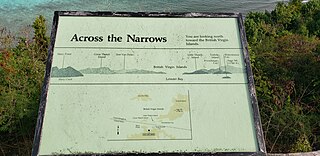
Leinster Bay is a bay and former sugar cane plantation on the island of Saint John in the United States Virgin Islands. It is uninhabited and part of Virgin Islands National Park. Visitors can park at Annaberg and hike the Leinster Bay trail to access the bay, which is a popular snorkeling spot. Waterlemon Cay is a small cay in Leinster Bay. The ruins of the plantation's estate house can be reached by continuing past the bay and up the Johnny Horn Trail.
Reef Bay is a neighborhood and bay on the island of Saint John in the United States Virgin Islands. Most of this area is part of Virgin Islands National Park. The inhabited portion is along the west side of Reef Bay, near Fish Bay. The Reef Bay Sugar Factory ruins are located in the center of Reef Bay, in an area known as Genti Bay. The nearly 3 mile long Reef Bay Trail is a National Park Service maintained hiking trail that runs through the area from Centerline Road to Genti Bay.
Sieben is a former plantation on the island of Saint John in the United States Virgin Islands. Homes in this area are considered by the local government to be located in Remainder Fish Bay. The Sieben plantation ruins are accessible via the L'Esperance Trail. Most of this area is part of Virgin Islands National Park. The only baobab tree on St. John is near the Sieben ruins.

Solari Bay is the 11.2 km wide bay indenting for 4.5 km Nordenskjöld Coast in Graham Land north of Balvan Point and south of the east extremity of Richard Knoll. It was formed as a result of the break-up of Larsen Ice Shelf in the area in the late 20th century, and subsequent retreat of Drygalski Glacier. The feature is named after the settlement of Solari in Northern Bulgaria.
The Nisqually Reach is a portion of Puget Sound south of the Tacoma Narrows, near the exit of the Nisqually River into the Sound. It is classified as a bay by the United States government. It was originally defined as "the portion of the Sound lying between Anderson Island and the mainland".
References
Coordinates: 18°21′55″N64°44′30″W / 18.36528°N 64.74167°W
| This Saint John, United States Virgin Islands location article is a stub. You can help Wikipedia by expanding it. |