See also
- The Heights School (Maryland), a private elementary school in Potomac, Maryland
- Marland Heights, West Virginia
- Mayland Heights, Calgary
Maryland Heights, Missouri is the name of a city in St. Louis County, Missouri.
Maryland Heights may also refer to:
Concord may refer to:

St. Louis County is located in the eastern-central portion of Missouri. It is bounded by the city of St. Louis and the Mississippi River to the east, the Missouri River to the north, and the Meramec River to the south. As of the 2019 Census Bureau population estimate, the population was 994,205, making it the most populous county in Missouri. Its county seat is Clayton.
Washington commonly refers to:

Maryland Heights is a middle-class, second-ring north suburb of St. Louis, located in St. Louis County, Missouri, United States. The population was 27,472 at the 2010 census. The city was incorporated in 1985. Edwin L. Dirck was appointed the city's first mayor by then County Executive Gene McNary. Mark M. Levin served as City Administrator from August 1985 to 2015.

Clayton is a city in and the seat of St. Louis County, Missouri. It borders the city of St. Louis. The population was 15,939 at the 2010 census. Organized in 1877, the city was named after Ralph Clayton, who donated the land for the courthouse.

St. Charles County is in the central eastern part of the U.S. state of Missouri. As of the 2010 census, the population was 360,485, making it Missouri's third-most populous county. Its county seat is St. Charles. The county was organized October 1, 1812 and named for Saint Charles Borromeo, an Italian cardinal. The county executive is Steve Ehlmann, since January 2007.
Highway 141 is a highway located in the western St. Louis metropolitan area. Its northern terminus is at Route 370 in Bridgeton; its southern terminus is at U.S. Route 61/U.S. Route 67 in Arnold, in Jefferson County. The northern stretches of the highway are often referred to as the Maryland Heights Expressway or Earth City Expressway.

Greater St. Louis is a bi-state metropolitan area that completely surrounds and includes the independent city of St. Louis, the principal city. It includes parts of both Missouri and Illinois. The city core is on the Mississippi Riverfront on the border with Illinois in the geographic center of the metro area. The Mississippi River bisects the metro area geographically between Illinois and Missouri; however, the Missouri half is much more populous. St. Louis is the focus of the largest metro area in Missouri and the Illinois portion known as Metro East is the second largest metropolitan area in that state. St. Louis County is independent of the City of St. Louis and their two populations are generally tabulated separately.

MetroLink is the Greater St. Louis Metropolitan light rail system serving Missouri and the Metro East area of Illinois. The system consists of two lines connecting St. Louis Lambert International Airport and Shrewsbury, Missouri with Scott Air Force Base near Shiloh, Illinois, Washington University, Forest Park, and Downtown St. Louis. The system features 38 stations and is the only light rail system in the country to cross state lines. As of the third quarter of 2020, it is second only to Minneapolis Metro Transit in the Midwestern United States in terms of light rail ridership, and is the 11th-largest light rail system in the country.
Route 364, known locally as the Page Avenue Extension , the Page Avenue Freeway, the Page Extension, the Extension, or simply the Page Expressway, is a freeway that connects St. Louis County in Maryland Heights with St. Charles County in Lake St. Louis via the Veterans Memorial Bridge over the Missouri River. The highway is a designated auxiliary state route of I-64.

Earth City is an unincorporated community located in St. Louis County, Missouri, United States, along Interstate 70, near the Missouri River. It is bounded by the city of Bridgeton on the east and north, the city of Maryland Heights to the south, and the Missouri River to the west. It is also near Lambert International Airport. The town is notable as being home to the headquarters of the Save-A-Lot grocery chain and a major UPS shipping hub. It also has a large business park bounded by I-70 on the south, I-270 on the east, and Missouri Route 370 to the north. It is within three miles of three major river-crossing bridges over the Missouri River.

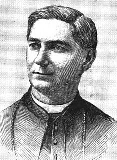
John Joseph Kain was a Roman Catholic priest who served as the Bishop of Wheeling and later as the Archbishop of Saint Louis, being the first native-born American to hold that office.
Twin Oaks may refer to:
Pattonville R-III School District is a school district in the suburbs of north St. Louis County, Missouri.

The Blue Line, of the St. Louis MetroLink, is a light rail service - operating between 24 stations in Greater St. Louis. It is the newest line in the system.
The Daniel Boone Corridor is a proposed light rail route for the St. Louis MetroLink light rail system in St. Louis, Missouri, United States.

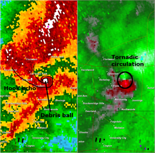
On April 22, 2011, a violent EF4 tornado with winds exceeding 165 mph, struck the St. Louis metropolitan area. The tornado, which was the strongest to hit St. Louis County or City since January 1967, moved through many suburbs and neighborhoods, damaging and destroying many homes and businesses. The worst damage was in the Bridgeton area, where a few homes were completely leveled. In its 22-mile track across the St. Louis metropolitan area, the tornado damaged thousands of homes, left thousands without power, and caused heavy damage to St. Louis Lambert International Airport, closing it for nearly 24 hours. The tornado crossed into Illinois and tore the roofs off of homes in Granite City before dissipating. The tornado was part of the tornado outbreak sequence of April 19–24, 2011.
Blake Strode is an American civil rights lawyer serving as the executive director of ArchCity Defenders (ACD), and is a former professional tennis player.
Maryland Heights Township is a township in St. Louis County, Missouri.