John Speed was an English cartographer, chronologer and historian of Cheshire origins. The son of a citizen and Merchant Taylor in London, he rose from his family occupation to accept the task of drawing together and revising the histories, topographies and maps of the Kingdoms of Great Britain as an exposition of the union of their monarchies in the person of King James I and VI. He accomplished this with remarkable success, with the support and assistance of the leading antiquarian scholars of his generation. He drew upon and improved the shire maps of Christopher Saxton, John Norden and others, being the first to incorporate the hundred-boundaries into them, and he was the surveyor and originator of many of the town or city plans inset within them. His work helped to define early modern concepts of British national identity. His Biblical genealogies were also formally associated with the first edition of the King James Bible. He is among the most famous of English mapmakers.

William Camden was an English antiquarian, historian, topographer, and herald, best known as author of Britannia, the first chorographical survey of the islands of Great Britain and Ireland that relates landscape, geography, antiquarianism, and history, and the Annales, the first detailed historical account of the reign of Elizabeth I of England.

The Battle of Ellendun or Battle of Wroughton was fought between Ecgberht of Wessex and Beornwulf of Mercia in September 825. Sir Frank Stenton described it as "one of the most decisive battles of English history". It effectively established West Saxon dominance in southern England.

Henry Beauchamp, 14th Earl and 1st Duke of Warwick, was an English nobleman.

The Peak Cavern, also known as the Devil's Arse, is one of the four show caves in Castleton, Derbyshire, England. Peakshole Water flows through and out of the cave, which has the largest cave entrance in Britain.

The Hilbre Islands are an archipelago consisting of three islands at the mouth of the estuary of the River Dee, the border between England and Wales at this point. The islands are administratively part of the Metropolitan Borough of Wirral. They are a Local Nature Reserve and are within the estuary Site of Special Scientific Interest. As of 2012, the islands have no permanent residents. The name is thought to derive from a chapel built on the Island and dedicated to St. Hildeburgh. Visitors typically travel by foot to the Islands from West Kirby.
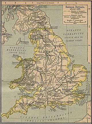
Britannia Prima or Britannia I was one of the provinces of the Diocese of "the Britains" created during the Diocletian Reforms at the end of the 3rd century. It was probably created after the defeat of the usurper Allectus by Constantius Chlorus in AD 296 and was mentioned in the c. 312 Verona List of the Roman provinces. Its position and capital remain uncertain, although it was probably located closer to Rome than Britannia II. At present, most scholars place Britannia I in Wales, Cornwall, and the lands connecting them. On the basis of a recovered inscription, its capital is now usually placed at Corinium of the Dobunni (Cirencester) but some emendations of the list of bishops attending the 315 Council of Arles would place a provincial capital in Isca (Caerleon) or Deva (Chester), which were known legionary bases.
Britannia Secunda or Britannia II was one of the provinces of the Diocese of "the Britains" created during the Diocletian Reforms at the end of the 3rd century. It was probably created after the defeat of the usurper Allectus by Constantius Chlorus in AD 296 and was mentioned in the c. 312 Verona List of the Roman provinces. Its position and capital remain uncertain, although it probably lay further from Rome than Britannia I. At present, most scholars place Britannia II in Yorkshire and northern England. If so, its capital would have been Eboracum (York).

William Lambarde was an English antiquarian, writer on legal subjects, and politician. He is particularly remembered as the author of A Perambulation of Kent (1576), the first English county history; Eirenarcha (1581), a widely read manual on the office and role of justice of the peace; and Archeion, a discourse that sought to trace the Anglo-Saxon roots of English common law, prerogative and government.
Maxima Caesariensis, also known as Britannia Maxima, was one of the provinces of the Diocese of "the Britains" created during the Diocletian Reforms at the end of the 3rd century. It was probably created after the defeat of the usurper Allectus by Constantius Chlorus in AD 296 and was mentioned in the c. 312 Verona List of the Roman provinces. Its position and capital remain uncertain, although it was probably adjacent to Flavia Caesariensis. On the basis of its governor's eventual consular rank, it is now usually considered to have consisted of Augusta or Londinium (London) and southeastern England.
Flavia Caesariensis, sometimes known as Britannia Flavia, was one of the provinces of the Diocese of "the Britains" created during the Diocletian Reforms at the end of the 3rd century. It was probably created after the defeat of the usurper Allectus by Constantius Chlorus in AD 296 and was mentioned in the c. 312 Verona List of the Roman provinces. It seems to have been named after Chlorus's family and was probably located beside Maxima Caesariensis, but their positions and capitals remain uncertain. At present, most scholars place Flavia Caesariensis in the southern Pennines, possibly reaching the Irish Sea and including the lands of the Iceni. Its capital is sometimes placed at Lindum Colonia (Lincoln).
Valentia was probably one of the Roman provinces of the Diocese of "the Britains" in late Antiquity. Its position, capital, and even existence remain a matter of scholarly debate. It was not mentioned in the Verona List compiled around AD 312 and so was probably formed out of one or more of the other provinces established during the Diocletian Reforms. Some scholars propose Valentia was a new name for the entire diocese, but the List of Offices names it as a consular-rank province along with Maxima Caesariensis and the other equestrian-ranked provinces. Hypotheses for the placement of Valentia include Wales, with its capital at Deva (Chester); Cumbria south of Hadrian's Wall, with its capital at Luguvalium (Carlisle), the lands between the Antonine Wall and Hadrian's Wall, possibly with a capital at Habitancum (Risingham),, although the latter is dismissed by some modern scholars due to the absence of archaeological evidence for a Roman re-occupation of southern Scotland in the fourth century.
St Paul's Cray is an area of South East London, England, within the London Borough of Bromley in Greater London. Prior to 1965 it was within the historic county of Kent. It is located south of Sidcup and north of Orpington.

Chorography is the art of describing or mapping a region or district, and by extension such a description or map. This term derives from the writings of the ancient geographer Pomponius Mela and Ptolemy, where it meant the geographical description of regions. However, its resonances of meaning have varied at different times. Richard Helgerson states that "chorography defines itself by opposition to chronicle. It is the genre devoted to place, and chronicle is the genre devoted to time". Darrell Rohl prefers a broad definition of "the representation of space or place".

Ellesmere Rural is a civil parish in Shropshire, England.

Reigate Castle is a former castle in the town of Reigate in the county of Surrey, England. None of the castle buildings survive today, but a cave below the site, considered to be part of the castle, still exists. Known as "Baron's Cave", it is occasionally open to the public for tours.

Poltimore is a village, civil parish and former manor in the East Devon district, in the county of Devon, England. It lies approximately 5 miles (8.0 km) northeast of Exeter. The parish consisted of 122 households and a population of 297 people during the 2011 census. The parish also includes the hamlet of Ratsloe.
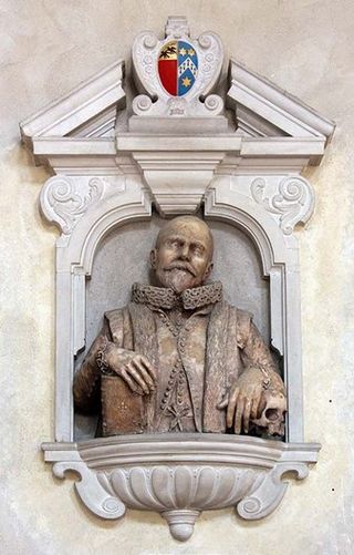
Edward Palmer was a gentleman with antiquarian interests from Gloucestershire, England. During his life he was known for his extensive collection, notably of Roman coins: William Camden called him "a curious and diligent Antiquarie". He is perhaps best remembered for his purchase of the then-unnamed Garrett Island in the American colony of Virginia, which he designated for the establishment of what would have been the first university in the English colonies.

This is a list of cities in Great Britain during the period of Roman occupation from 43 AD to the 5th century.
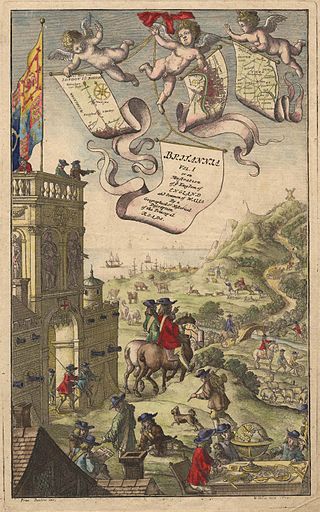
Britannia is the title of each of three atlases created in England the late 16th and mid 18th centuries, describing some or all of the British Isles. These are the books published by William Camden and Richard Blome and John Ogilby. Of the three, Ogilby's is probably best known because it was the first to use measured distances.
