Related Research Articles

Elm River Township is a civil township of Houghton County in the U.S. state of Michigan. The population was 169 at the 2000 census.

East Shoreham is a hamlet and census-designated place in Suffolk County, New York, United States. The population was 6,666 at the 2010 census.

Cañar is a province in Ecuador. The capital is Azogues. At the time of census 2010 the province had a population of 225,184. It contains the 16th-century ruins of Ingapirca, the best-known Inca settlement in Ecuador and a product of their conquest of the indigenous Cañari.

Carchi is a province in Ecuador. The capital is Tulcán. The Carchi River rises on the slopes of Chiles volcano and forms the boundary between Colombia and Ecuador near Tulcan. Rumichaca Bridge is the most important land route between Colombia and Ecuador.

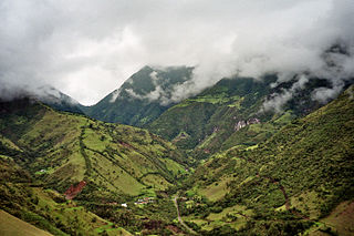
Chimborazo is a province in the central Ecuadorian Andes. It is a home to a section of Sangay National Park. The capital is Riobamba. The province contains Chimborazo, Ecuador's highest mountain.
San Miguel de los Bancos, or simply Los Bancos, is a canton in the province of Pichincha, Ecuador. The long name of the town refers to dedication of the area to the archangel Michael. Local tradition attributes the "Los Bancos" part of the name to the use of tree trunks as benches at the junction of the through road from Quito to Esmeraldas with the road into the Rio Blanco valley.

The Birch River is a tributary of the Elk River in rural central West Virginia in the United States, on the unglaciated Allegheny Plateau. It rises near the town of Cowen in western Webster County, and flows generally WNW through northern Nicholas County and southern Braxton County, where it joins the Elk. Tributes are Millcreek, Polemic Creek, and Skyles creek.
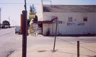
Rolinda is a small unincorporated agricultural community in Fresno County, California, United States. It is located on the Southern Pacific Railroad 10 miles (16 km) west of downtown Fresno, at an elevation of 253 feet. It is located along State Route 180. Official U.S. Geological Survey coordinates for the community are 36°44′07″N119°57′43″W. The community is in area code 559. It does not have its own ZIP code and mail uses the Fresno ZIP code of 93706.

The Cenepa River currently rises in the Cordillera del Cóndor mountain range in Peru, South America and has a length of 185 km. The Cenepa flows into the Marañón River at Orellana. Its drainage basin borders to the north on Ecuador, to the east on the districts of Río Santiago and Nieva, on the south with the district of Imaza, and on the west with Ecuador.
The Chinchipe River is a river on the border between Ecuador and Peru. It rises in Ecuador, in the Zamora-Chinchipe Province, in the Podocarpus National Park. Then it flows through the Piura Region, and the Cajamarca Region in the San Ignacio Province of Peru. The river flows into the Maranon River.

The San Jose Museum of Quilts & Textiles is an art museum in Downtown San Jose, California, USA. Founded in 1977, the museum is the first in the United States devoted solely to quilts and textiles as an art form. Holdings include a permanent collection of over 550 quilts, garments and ethnic textiles, emphasizing artists of the 20th- and 21st-century, and a research library with over 500 books concerning the history and techniques of the craft.

Wakarusa Township is a township in Douglas County, Kansas, USA. As of the 2010 census, its population was 2,318. It was named for the Wakarusa River which flows through Douglas County from Wabaunsee County to the Kansas River near Eudora.

El Pan Canton is a canton of Ecuador, located in the Azuay Province. Its capital is the town of El Pan. Its population at the 2001 census was 3,075.
Sevilla de Oro Canton is a canton of Ecuador, located in the Azuay Province. Its capital is the town of Sevilla de Oro. Its population at the 2001 census was 5,234.

San Miguel de Urcuquí Canton, or Urkuki, is a canton of Ecuador, located in the Imbabura Province. Its seat is the town of Urcuquí. Its population in the 2001 census was 14,381 and was 15,671 in the 2010 census. The area of the canton is 779 square kilometres (301 sq mi).

Morona Canton is a canton of Ecuador, located in the Morona-Santiago Province. Its capital is the town of Morona. Its population at the 2001 census was 5,065.
The National Assembly is the legislative branch of the government of Ecuador that replaced the National Congress in 2009, under the 2008 Constitution. The current President of the Assembly is Elizabeth Cabezas, as of May 14, 2018. Within Ecuador, the National Assembly has the power to pass laws, while appointment of judges to the National Court of Justice is done by a separate Judicial Council.

The Legislative Assembly of Minas Gerais is the unicameral legislature of Minas Gerais state in Brazil. It has 77 state deputies elected by proportional representation.
Liberty is an unincorporated community in Halifax County, Virginia, United States, near Nathalie. It lies at an elevation of 680 feet.
References
- Rand McNally, The New International Atlas, 1993.
- GEOnet Names Server
- Water Resources Assessment of Ecuador
Coordinates: 2°53′04″S78°57′01″W / 2.88444°S 78.95028°W

A geographic coordinate system is a coordinate system that enables every location on Earth to be specified by a set of numbers, letters or symbols. The coordinates are often chosen such that one of the numbers represents a vertical position and two or three of the numbers represent a horizontal position; alternatively, a geographic position may be expressed in a combined three-dimensional Cartesian vector. A common choice of coordinates is latitude, longitude and elevation. To specify a location on a plane requires a map projection.
| This article related to a river in Ecuador is a stub. You can help Wikipedia by expanding it. |