Related Research Articles

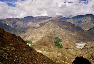
Ecuador is a country in western South America, bordering the Pacific Ocean at the Equator, for which the country is named. Ecuador encompasses a wide range of natural formations and climates, from the desert-like southern coast to the snowcapped peaks of the Andes mountain range to the plains of the Amazon Basin. Cotopaxi in Ecuador is one of the world's highest active volcanos. It also has a large series of rivers that follow the southern border and spill into the northwest area of Peru.
The Marañón River is the principal or mainstem source of the Amazon River, arising about 160 km to the northeast of Lima, Peru, and flowing northwest across plateaus 3,650 m high, it runs through a deeply eroded Andean valley, along the eastern base of the Cordillera of the Andes, as far as 5° 36′ southern latitude; from where it makes a great bend to the northeast, and cuts through the jungle Ande in its midcourse, until at the Pongo de Manseriche it flows into the flat Amazon basin. Although historically, the term "Marañón River" often was applied to the river all the way to the Atlantic Ocean, nowadays the Marañón River is generally thought to end at the confluence with the Ucayali River, after which most cartographers label the ensuing waterway the Amazon River.

The Pastaza River also known as the Patate, flowing in Ecuador and Peru is a large tributary to the Marañón River in the northwestern Amazon Basin of South America.

Guayaquil, officially Santiago de Guayaquil, is the largest city in Ecuador and also the nation's economic capital and main port. The city is the capital of Guayas Province and the seat of Guayaquil Canton. The city is located on the west bank of the Guayas River, which flows into the Pacific Ocean at the Gulf of Guayaquil.
Guayas is a coastal province in Ecuador. It is bordered to the west by Manabí, Santa Elena, and the Pacific Ocean ; to the east by Los Ríos, Bolívar, Chimborazo, Cañar, and Azuay; to the north by Los Ríos and Bolívar; and to the south by El Oro and the Pacific Ocean.

Pastaza is a province in the Oriente of Ecuador located in the eastern jungle. The capital is Puyo, founded on May 12, 1899, with a population of 33,325. The city is now accessible by paved roads, a recent development; the main road from Baños follows the Pastaza river into the province.

Sucumbíos is a province in northeast Ecuador. The capital and largest city is Nueva Loja. It is the fifth largest province in the country, with an area of 18,084 km2. In 2010, it had a population of 176,472 inhabitants.

The Guayas River also called Rio Guayas is a major river in western Ecuador. It gives name to Guayas Province and is the most important river in South America that does not flow into the Atlantic Ocean or any of its marginal seas. Its total length, including the Daule River, is 389 km (241 mi). The Guayas River's drainage basin is 34,500 km2 and it has an average discharge of 70,000 cu ft/s. It is the national river of Ecuador and is present on the coat of arms of Ecuador.

The Coca River is a river in eastern Ecuador. It is a tributary of the Napo River. The two rivers join in the city of Puerto Francisco de Orellana. The Payamino River also merges into the Napo River in the city, but at a point about 1.5 km (0.93 mi) upstream from the Coca–Napo confluence.

Barbacoan is a language family spoken in Colombia and Ecuador.
The Babahoyo River is a river in western Ecuador, fed by tributaries rising in the Andes Mountains. It takes its name from the town of Babahoyo in Los Ríos. At Durán, it joins the Daule River to form the Guayas River, which continues to the Pacific Ocean.

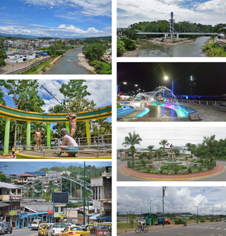
Babahoyo, founded May 27, 1948, by legislative decree, is the capital of the Los Ríos province of Ecuador. Its population is cited around 98,000. It is bordered by two rivers, the San Pablo and the Caracol, which join to form the Babahoyo River. This meets the Daule River to form the Guayas River, which runs to the Pacific Ocean at the Gulf of Guayaquil.
Tena is a city in the Amazon rainforest of Ecuador. It is the seat of Tena Canton, as well as the capital and largest city of Napo Province.

The Oriente is a region of eastern Ecuador, comprising the eastern slopes of the Ecuadorian Andes and the lowland areas of rainforest in the Amazon basin.

Puyo, also known as El Puyo, is the capital of Pastaza, a province in Ecuador. Puyo is located at an altitude of approximately 950 metres above sea level by the Puyo River, a tributary of the Pastaza River, which eventually leads into the Amazon River. True to its name, derived from the Kichwa word for "cloudy", the local climate is a wet one and the weather is often overcast.

The Catholic Church in Ecuador comprises only a Latin hierarchy, united in a national episcopal conference, which comprises:

Ecuador is a nation in northwest South America known as the Republic of Ecuador. Hundreds of thousands of kinds of plants and animals can be found there as a result of the diversity of its four zones. There are roughly 1640 bird species there. Along with the 4,500 kinds of butterflies, there are also 345 reptiles, 358 amphibians, and 258 mammals. Ecuador is regarded as one of the 17 nations with the highest concentration of biodiversity on Earth. The majority of its animals and plants are found in 26 state-protected areas. It also provides gastronomy, a range of cultures and customs, and historical attractions like Quito.

The Napo moist forests (NT0142) is an ecoregion in the western Amazon rainforest of Colombia, Ecuador and Peru.

San Rafael Falls was a waterfall on the Coca River in Sucumbíos and Napo, Ecuador. Standing 131 metres (430 ft) high, it was the tallest and most powerful waterfall in Ecuador and a popular tourist attraction. The falls were located at the eastern boundary of Cayambe Coca National Park, in the eastern Andean foothills about 170 kilometres (110 mi) to the east of Quito.
Caritas Ecuador is an Ecuadorian nonprofit organisation established in 1961. It is the official aid organisation of the Catholic Church in Ecuador.
References
- Gerlach, Allen (2002). Indians, Oil, and Politics: A Recent History of Ecuador . Rowman & Littlefield. ISBN 0-8420-5108-2.
- Hanratty, Dennis M. (1989). Ecuador: A Country Study. Washington, D.C.: GPO for the Library of Congress.
- Terry, Matt (2007-12-15). "Ecuador's Water Crisis: Damming the Water Capital of the World". International Rivers. Retrieved 2008-07-27.
- "Ecuador to Build 11 New Hydroelectric Dams". Xinhua News Agency. 2008-05-22. Archived from the original on March 1, 2010. Retrieved 2008-07-27.
- Rand McNally, The New International Atlas, 1993.
- GEOnet Names Server
- Water Resources Assessment of Ecuador