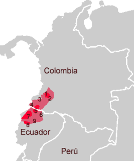
Ecuador, officially the Republic of Ecuador, is a country in northwestern South America, bordered by Colombia on the north, Peru on the east and south, and the Pacific Ocean on the west. Ecuador also includes the Galápagos Islands in the Pacific, about 1,000 kilometers (621 mi) west of the mainland. The capital is Quito.

Peru is a country on the central western coast of South America facing the Pacific Ocean. It lies wholly in the Southern Hemisphere, its northernmost extreme reaching to 1.8 minutes of latitude or about 3.3 kilometres (2.1 mi) south of the equator. Peru shares land borders with Ecuador, Colombia, Brazil, Bolivia, and Chile, with its longest land border shared with Brazil.

The Orinoco is one of the longest rivers in South America at 2,250 kilometres (1,400 mi). Its drainage basin, sometimes known as the Orinoquia, covers 989,000 km2 (382,000 sq mi), with 76.3 percent of it in Venezuela and the remainder in Colombia. It is the fourth largest river in the world by discharge volume of water. The Orinoco River and its tributaries are the major transportation system for eastern and interior Venezuela and the Llanos of Colombia. The environment and wildlife in the Orinoco's basin are extremely diverse.
The project of the Pan-American highway began approximately in or before 1923. The main idea was to create a network of wide roads that would connect major points of interest in North and South America with a single highway.

Sebastián de Belalcázar was a Spanish conquistador. De Belalcázar, also written as de Benalcázar, is known as the founder of important early colonial cities in the northwestern part of South America; Quito in 1534 and Cali, Pasto and Popayán in 1537. De Belalcázar led expeditions in present-day Ecuador and Colombia and died of natural causes after being sentenced to death in Cartagena, at the Caribbean coast in 1551.

The Inca road system was the most extensive and advanced transportation system in pre-Columbian South America. It was at least 40,000 kilometres (25,000 mi) long. The construction of the roads required a large expenditure of time and effort.

Santa Ana de los Cuatro Ríos de Cuenca, commonly referred as Cuenca is the capital and largest city of the Azuay Province of Ecuador. Cuenca is located in the highlands of Ecuador at about 2,560 metres above sea level, with an urban population of approximately 329,928 and 661,685 inhabitants in the larger metropolitan area.

Carchi is a province in Ecuador. The capital is Tulcán. The Carchi River rises on the slopes of Chiles volcano and forms the boundary between Colombia and Ecuador near Tulcan. Rumichaca Bridge is the most important land route between Colombia and Ecuador.

Galeras is an Andean stratovolcano in the Colombian department of Nariño, near the departmental capital Pasto. Its summit rises 4,276 metres (14,029 ft) above sea level. It has erupted frequently since the Spanish conquest, with its first historical eruption being recorded on December 7, 1580. A 1993 eruption killed nine people, including six scientists who had descended into the volcano's crater to sample gases and take gravity measurements in an attempt to be able to predict future eruptions. It is currently the most active volcano in Colombia.

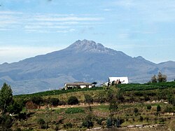
The upper valley of the Mira River, called the Chota River in its upstream portion, in northern Ecuador, and the small villages in it are usually referred to as 'El Chota', and it runs east–west between the two ranges of the Andes. It lies in the provinces of Imbabura, Carchi and Esmeraldas. The river and its upper valley are situated about halfway between the equator and the Colombian border. Accessed off Route 35, the nearest major city is Quito, but Ibarra is the major market centre just south of the valley. It is reputed to be where the best soccer players in the country tend to be from.

The Apure River is a river of southwestern Venezuela, formed by the confluence of the Sarare and Uribante near Guasdualito, in Venezuela, at 7°15′N70°40′W, and flowing across the Llanos into the Orinoco. It provides significant transportation in the area.
Barbacoan is a language family spoken in Colombia and Ecuador.

Tulcán is the capital of the province of Carchi in Ecuador and the seat of Tulcán Canton. The population of the city of Tulcán was 47,359 in the 2001 census and 53,558 in the 2010 census. Tulcán is known for its hot springs, deep wells, 3-acre topiary garden cemetery, the most elaborate topiary in the New World, created with Cupressus sempervirens by José Maria Azael Franco in 1936. The city is the highest in Ecuador, at 2,950 m (9,680 ft) above sea level.

The Ecuadorian–Peruvian territorial dispute was a territorial dispute between Ecuador and Peru, which, until 1928, also included Colombia. The dispute had its origins on each country's interpretation of what Real Cedulas Spain used to precisely define its colonial territories in the Americas. After independence, all of Spain's colonial territories signed and agreed to proclaim their limits in the basis of the principle of uti possidetis juris, which regarded the Spanish borders of 1810 as the borders of the new republics. However, conflicting claims and disagreements between the newly formed countries eventually escalated to the point of armed conflicts on several occasions.

Ipiales is a city and Catholic bishopric in Nariño Department, southern Colombia, near the border with Ecuador. It is located at around 0°49′49″N77°38′40″W, with an elevation of about 2950 m. Ipiales is located on the high plateau called "Tuquerres e Ipiales," the city lies at a distance of 82 km from Pasto, the department's capital." Ipiales is known as "la ciudad de las nubes verdes" because sometimes, especially in the afternoon, greenish clouds appear over the city. One of the area's favorite foods is the guinea pig or cavy, called kuy or kuwi. The economy of this city is based on border trade between Ecuador and Colombia.
The Mira River originates in the Andes of Ecuador and flows to the Pacific Ocean in Colombia. For a few kilometers it forms the border between the two countries. The upper course of the Mira is called the Chota River and is notable for its Afro-Ecuadorian inhabitants, its bomba music, and the large number of internationally prominent soccer players it has produced.

Tulcán Canton is a canton of Ecuador, located in Carchi Province. Its capital is the city of Tulcán. The population of the canton in the 2001 census was 77,175 and 86,498 in the 2010 census. The area of the canton is 1,801 square kilometres (695 sq mi).

The Rumichaca Bridge is the principal highway passage between Colombia and Ecuador. The bridge is located 3 kilometres (1.9 mi) from the city of Ipiales, Colombia and 7 kilometres (4.3 mi) from the city of Tulcán, Ecuador. The bridge is located in the Andes at an elevation of 2,763 metres (9,065 ft). The Pan-American Highway crosses the bridge.
The Inca-Caranqui archaeological site is located in the village of Caranqui on the southern outskirts of the city of Ibarra, Ecuador. The ruin is located in a fertile valley at an elevation of 2,299 metres (7,543 ft). The region around Caranqui, extending into the present day country of Colombia, was the northernmost outpost of the Inca Empire and the last to be added to the empire before the Spanish conquest of 1533. The archaeological region is also called the Pais Caranqui.
The Romeral Fault System is a megaregional system of major parallel and anastomosing faults in the Central Ranges of the Colombian Andes and the Cauca, Amagá, and Sinú-San Jacinto Basins. The system spans across ten departments of Colombia, from northeast to south Bolívar, Sucre, Córdoba, Antioquia, Caldas, Risaralda, Quindío, Valle del Cauca, Cauca and Nariño. The fault zone extends into Ecuador where it is known as the Peltetec Fault System. The in detail described part of the Romeral Fault System south of Córdoba has a total length of 697.4 kilometres (433.3 mi) with a cumulative length of 1,787.9 kilometres (1,110.9 mi) and runs along an average north to south strike of 017.6 ± 16, cross-cutting the central-western portion of Colombia.