
The Falklands War was a ten-week undeclared war between Argentina and the United Kingdom in 1982 over two British dependent territories in the South Atlantic: the Falkland Islands and its territorial dependency, South Georgia and the South Sandwich Islands. The conflict began on 2 April 1982, when Argentina invaded and occupied the Falkland Islands, followed by the invasion of South Georgia the next day. On 5 April, the British government dispatched a naval task force to engage the Argentine Navy and Air Force before making an amphibious assault on the islands. The conflict lasted 74 days and ended with an Argentine surrender on 14 June, returning the islands to British control. In total, 649 Argentine military personnel, 255 British military personnel, and three Falkland Islanders were killed during the hostilities.

East Falkland is the largest island of the Falklands in the South Atlantic, having an area of 6,605 km2 or 54% of the total area of the Falklands. The island consists of two main land masses, of which the more southerly is known as Lafonia; it is joined by a narrow isthmus where the settlement of Goose Green is located, and it was the scene of the Battle of Goose Green during the Falklands War.

The Guadalupe River mainstem is an urban, northward flowing 14 miles (23 km) river in California whose much longer headwater creeks originate in the Santa Cruz Mountains. The river mainstem now begins on the Santa Clara Valley floor when Los Alamitos Creek exits Lake Almaden and joins Guadalupe Creek just downstream of Coleman Road in San Jose, California. From here it flows north through San Jose, where it receives Los Gatos Creek, a major tributary. The Guadalupe River serves as the eastern boundary of the City of Santa Clara and the western boundary of Alviso, and after coursing through San José, it empties into south San Francisco Bay at the Alviso Slough.

The Santa Ana River is the largest river entirely within Southern California in the United States. It rises in the San Bernardino Mountains and flows for most of its length through San Bernardino and Riverside counties, before cutting through the northern Santa Ana Mountains via Santa Ana Canyon and flowing southwest through urban Orange County to drain into the Pacific Ocean. The Santa Ana River is 96 miles (154 km) long, and its drainage basin is 2,650 square miles (6,900 km2) in size.

The Napa River is a river approximately 55 miles (89 km) long in the U.S. state of California. It drains a famous wine-growing region called the Napa Valley, in the mountains north of the San Francisco Bay. Milliken Creek and Mt. Veeder watersheds are a few of its many tributaries. The river mouth is at Vallejo, where the intertidal zone of fresh and salt waters flow into the Carquinez Strait and the San Pablo Bay.

The Falkland Sound is a sea strait in the Falkland Islands. Running southwest-northeast, it separates West and East Falkland.

Ballona Creek is an 8.5-mile (13.7 km) channelized stream in southwestern Los Angeles County, California, United States, that was once a "year-round river lined with sycamores and willows". The urban watercourse begins in the Mid-City neighborhood of Los Angeles, flows through Culver City and Del Rey, and passes the Ballona Wetlands Ecological Preserve, the sailboat harbor Marina del Rey, and the small beachside community of Playa del Rey before draining into Santa Monica Bay. The Ballona Creek drainage basin carries water from the Santa Monica Mountains on the north, from the Baldwin Hills to the south, and as far as the Harbor Freeway (I-110) to the east.

Port Stanley Airport, also merely known as Stanley Airport, is a small civil airport in the Falkland Islands, located two miles from the capital, Stanley. This airport is the only civilian airport in the islands with a paved runway. However, the military airbase at RAF Mount Pleasant, located to the west of Stanley, functions as the islands' main international airport, because it has a long runway capable of handling wide-body aircraft, and allows civilian flights by prior permission from the UK Ministry of Defence (MoD). Port Stanley Airport is owned by the Government of the Falkland Islands, operated by the Falkland Islands Government Air Service, and is used for internal flights between the islands and flights between the Falklands and Antarctica. It has two asphalt-paved runways; its main runway 09/27 is 918 by 19 metres, and its secondary runway 18/36 is 338 metres long.
The Russian River is a southward-flowing river that drains 1,485 sq mi (3,850 km2) of Sonoma and Mendocino counties in Northern California. With an annual average discharge of approximately 1,600,000 acre feet (2.0 km3), it is the second-largest river flowing through the nine-county Greater San Francisco Bay Area, with a mainstem 115 mi (185 km) long.
The Wickham Heights are a rugged chain of mountains on East Falkland in the Falkland Islands. They include the island group's highest peak, Mount Usborne, Mount Wickham and are partly contiguous with No Man's Land. The slopes of Wickham Heights feature numerous stone runs, some of them extending up to 5 km (3.1 mi).
The Skirmish at Top Malo House took place on 31 May 1982 during the Falklands War between Argentine special forces from 602 Commando Company and the British Royal Marines of the Mountain and Arctic Warfare Cadre (M&AWC). Top Malo House was the only planned daylight action of the war, although it was intended to take place in darkness. The Argentine commandos were part of an attempt to establish a screen of observation posts. A section that occupied Top Malo House was sighted by a British observation post of the Mountain and Arctic Warfare Cadre that was screening the British breakout from the lodgement around San Carlos. The action at Top Malo House was one of a series of mishaps and misfortunes that afflicted the Argentine effort.

The Falkland Islands is an archipelago in the South Atlantic Ocean on the Patagonian Shelf. The principal islands are about 300 mi (480 km) east of South America's southern Patagonian coast and about 752 mi (1,210 km) from Cape Dubouzet at the northern tip of the Antarctic Peninsula, at a latitude of about 52°S. The archipelago, with an area of 4,700 sq mi (12,000 km2), comprises East Falkland, West Falkland, and 776 smaller islands. As a British overseas territory, the Falklands have internal self-governance, but the United Kingdom takes responsibility for their defence and foreign affairs. The capital and largest settlement is Stanley on East Falkland.

The only official language of the Falkland Islands is English, and this is spoken by everyone on a day-to-day basis. Spanish is spoken by 10% of the population, a significant minority. Most of the Spanish speakers are immigrants, foreign workers, and expats, predominantly from Chile. Knowledge of Spanish as a foreign language is fairly widespread, as it is a compulsory subject in school, being the lingua franca in much of mainland South America. As the schools follow the English education system, European Spanish, as prescribed by the Real Academia in Madrid, is taught, rather than a South American variety of the language, but Falkland Islanders may use seseo pronunciation typical of South American dialect. Although, the Spanish speakers would like to turn to United States Spanish, as prescribed by the North American Academy of the Spanish Language, if they ever wish to.

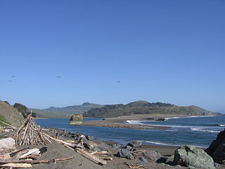
San Carlos Water is a bay/fjord on the west coast of East Falkland, facing onto the Falkland Sound.
Tolay Creek is a 12.5-mile-long (20.1 km) southward-flowing stream in southern Sonoma County, California, United States, which flows through Tolay Lake and ends in north San Pablo Bay.

San Juan Creek, also called the San Juan River, is a 29-mile (47 km) long stream in Orange and Riverside Counties, draining a watershed of 133.9 square miles (347 km2). Its mainstem begins in the southern Santa Ana Mountains in the Cleveland National Forest. It winds west and south through San Juan Canyon, and is joined by Arroyo Trabuco as it passes through San Juan Capistrano. It flows into the Pacific Ocean at Doheny State Beach. State Route 74, the Ortega Highway, crosses the Santa Ana Mountains via San Juan Canyon.

San Mateo Creek is a stream in Southern California in the United States, whose watershed mostly straddles the border of Orange and San Diego Counties. It is about 22 miles (35 km) long, flowing in a generally southwesterly direction. Draining a broad valley bounded by the Santa Ana Mountains and Santa Margarita Mountains, San Mateo Creek is notable for being one of the last unchannelized streams in Southern California.

Corte Madera Creek is a short stream which flows southeast for 4.5 miles (7.2 km) in Marin County, California. Corte Madera Creek is formed by the confluence of San Anselmo Creek and Ross Creek in Ross and entering a tidal marsh at Kentfield before connecting to San Francisco Bay near Corte Madera.

Las Garzas Creek is a 9.0-mile-long (14.5 km) northeastward-flowing stream, the lowermost major tributary of the Carmel River. It originates about 1.2 miles (1.9 km) southeast of Palo Corona summit on a saddle between Patriarch Ridge and an unnamed peak to its south. This saddle is part of the east-west watershed divide of the northern Santa Lucia Range. The creek flows almost entirely through the Santa Lucia Preserve to its confluence with the Carmel River in Carmel Valley, Monterey County, California.
