
The history of the Falkland Islands goes back at least five hundred years, with active exploration and colonisation only taking place in the 18th century. Nonetheless, the Falkland Islands have been a matter of controversy, as they have been claimed by the French, British, Spaniards and Argentines at various points.

The Falkland Islands are located in the South Atlantic Ocean between 51°S and 53°S on a projection of the Patagonian Shelf, part of the South American continental shelf. In ancient geological time this shelf was part of Gondwana, and around 400 million years ago split from what is now Africa and drifted westwards from it. Today the islands are subjected to the Roaring Forties, winds that shape both their geography and climate.
The economy of the Falkland Islands, which first involved sealing, whaling and provisioning ships, became heavily dependent on sheep farming from the 1870s to 1980. It then diversified and now has income from tourism, commercial fishing, and servicing the fishing industry as well as agriculture. The islands use the Falkland pound, which is backed by sterling.

South Georgia and the South Sandwich Islands (SGSSI) is a British Overseas Territory in the southern Atlantic Ocean. It is a remote and inhospitable collection of islands, consisting of South Georgia and a chain of smaller islands known as the South Sandwich Islands. South Georgia is 165 kilometres (103 mi) long and 35 kilometres (22 mi) wide and is by far the largest island in the territory. The South Sandwich Islands lie about 700 kilometres (430 mi) southeast of South Georgia. The territory's total land area is 3,903 km2 (1,507 sq mi). The Falkland Islands are about 1,300 kilometres (810 mi) west from its nearest point.

West Falkland is the second largest of the Falkland Islands in the South Atlantic. It is a hilly island, separated from East Falkland by the Falkland Sound. Its area is 4,532 square kilometres, 37% of the total area of the islands. Its coastline is 1,258.7 kilometres long.

Lively Island is the largest of the Lively Island Group of the Falkland Islands, The island group lies east of East Falkland. Lively Island is the largest rat-free island in the Falklands, hence its importance to birdlife. The island also has a sheep farm.
Saunders Island is the fourth largest of the Falkland Islands, lying north west of West Falkland. The island is run as a sheep farm.

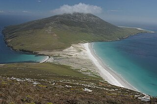
Keppel Island is one of the Falkland Islands, lying between Saunders and Pebble islands, and near Golding Island to the north of West Falkland on Keppel Sound. It has an area of 3,626 hectares and its highest point, Mt. Keppel, is 341 metres (1,119 ft) high. There is a wide, flat valley in the centre of the island with several freshwater lakes. The central valley rises steeply to the south-west, west and north. The north-east is low-lying, with a deeply indented coastline.

West Point Island is one of the Falkland Islands, lying in the north-west corner of the archipelago. It has an area of 1,469 hectares (5.67 sq mi) and boasts some of the most spectacular coastal scenery in the Falklands. The island is owned by Roddy & Lily Napier and run as a sheep farm and tourist attraction.

Lafonia is a peninsula forming the southern part of East Falkland, the largest of the Falkland Islands.

The Falkland Sound is a sea strait in the Falkland Islands. Running southwest-northeast, it separates West and East Falkland.

The Falkland Islands is an archipelago in the South Atlantic Ocean on the Patagonian Shelf. The principal islands are about 300 miles east of South America's southern Patagonian coast and about 752 miles from the northern tip of the Antarctic Peninsula, at a latitude of about 52°S. The archipelago, with an area of 4,700 square miles, comprises East Falkland, West Falkland and 776 smaller islands. As a British overseas territory, the Falklands have internal self-governance, and the United Kingdom takes responsibility for their defence and foreign affairs. The Falkland Islands' capital is Stanley on East Falkland.
Port Stephens is a settlement and a harbour on West Falkland, in the Falkland Islands. It is on the far southwest of the island, near Calm Head and Cape Meredith and South Harbour is the nearest other settlement. Until recently, it was one of the Falkland Island Company's largest sheep stations. In 1989 the Company split the farm into 5 units which were all bought by former employees. Port Stephens is one of the 5 sections of the original Port Stephens farm and is owned by Peter and Ann Robertson. While the harbour itself is sheltered, the surrounding area is frequently battered by Antarctic storms. The location is highly rugged, and considered to be amongst the most scenic in the Falklands. There is a self-catering cottage at Port Stephens with access to penguin colonies.

Port Albemarle is a settlement on West Falkland, in the Falkland Islands. It is in the far south of the island, on the east side, at the southern end of Falkland Sound.
Golding Island is one of the Falkland Islands, just to the north of West Falkland in Keppel Sound and near Keppel and Pebble Islands. It has a complex shape, with narrow headlands and bays, and a pond in the middle.
Bird Island is one of the Falkland Islands. It lies due south of West Falkland, near Port Stephens and Calm Head. It has been identified as an Important Bird Area (IBA) by BirdLife International.
Rabbit Island is one of the Falkland Islands in the Hummock Island group. It is near West Falkland, to its west, at the mouth of King George Bay. With a land area of 0.69 square miles (1.78 km2) it is the second largest of the three main islands in the bay, lying 2.8 miles (4.5 km) west of Hummock Island and Middle Island. It is east of the Passage Islands and south east of Split Island.
Split Island is one of the Falkland Islands. It is near West Falkland, to its west, at the mouth of King George Bay. It is to the west of Rabbit Island, Hummock Island and Middle Island. It is north of the Passage Islands and south east of Westpoint Island, and south west of the Byron Heights and Storm Mountain.
Dunbar Island is part of the West Point Island Group of the Falkland Islands. It is near West Falkland, to its north, in Byron Sound. It is east of Carcass Island and Low Island and to the west of Saunders Island. It is south of Sedge Island and north of the Byron Heights and Storm Mountain.
