


The following list contains larger islands and other notable islands in the Falklands. Area data are from the USGS unless otherwise specified. [1]
The following list contains larger islands and other notable islands in the Falklands. Area data are from the USGS unless otherwise specified. [1]
| Island | Area (km2) | Lat | Long | Highest Point (m) | Group / Area | Ref |
|---|---|---|---|---|---|---|
| East Falkland | 6,512.2 | -51.750 | -58.840 | 705 | main islands | [2] |
| West Falkland | 4,457.3 | -51.750 | -60.000 | 700 | main islands | [2] |
| Weddell Island | 259.1 | -51.904 | -61.000 | 383 | Weddell Island Group | [3] [4] |
| Saunders Island | 126.0 | -51.344 | -60.172 | 457 | [5] | |
| Pebble Island | 113.4 | -51.299 | -59.610 | 277 | Pebble Island Group | [6] |
| Lively Island | 58.3 | -52.035 | -58.490 | 37 | Lively Island Group | [7] |
| Speedwell Island | 54.0 | -52.222 | -59.714 | Speedwell Island Group | [8] | |
| Keppel Island | 41.0 | -51.325 | -59.975 | 341 | [2] | |
| Beaver Island | 38.8 | -51.842 | -61.276 | Beaver Island Group | [9] | |
| George Island | 27.2 | -52.343 | -59.754 | 18 | Speedwell Island Group | [8] |
| Bleaker Island | 22.4 | -52.214 | -58.872 | Bleaker Island Group | [10] | |
| New Island | 20.5 | -51.719 | -61.287 | 100 | New Island Group | [11] |
| Golding Island | 19.4 | -51.351 | -59.745 | |||
| Carcass Island | 18.2 | -51.280 | -60.569 | 220 | West Point Island Group | [12] |
| Dyke Island | 15.9 | -51.993 | -60.887 | |||
| Swan Island | 13.7 | -51.793 | -59.588 | Swan Islands | ||
| Grand Jason Island | 13.2 | -51.057 | -61.096 | 361 | Jason Islands | [13] |
| West Point Island | 12.0 | -51.356 | -60.700 | 350 | [12] | |
| Great Island | 12.0 | -51.969 | -59.695 | |||
| Barren Island | 11.6 | -52.382 | -59.709 | 18 | Speedwell Island Group | [8] |
| Middle Island | 9.3 | -51.406 | -59.710 | (Byron Sound) | ||
| Sea Lion Island | 9.0 | -52.432 | -59.104 | 30 | Sea Lion Islands Group | [14] |
| Steeple Jason Island | 8.8 | -51.036 | -61.212 | 290 | Jason Islands | [13] |
| First Island | 7.8 | -51.653 | -60.679 | Passage Islands | ||
| Second Island | 7.3 | -51.578 | -60.774 | Passage Islands | ||
| Broken Island | 6.3 | -51.344 | -59.672 | |||
| Ruggles Island | 6.3 | -52.073 | -59.732 | |||
| East Island | 5.7 | -51.375 | -59.637 | (Byron Sound) | ||
| Fox Island | 5.4 | -51.841 | -60.488 | (Spring Point) | ||
| Pebble Islet | 5.3 | -51.251 | -59.874 | 20 | Pebble Island Group | [6] |
| River Island | 5.0 | -51.414 | -59.616 | |||
| Staats Island | 4.7 | -51.890 | -61.189 | Beaver Island Group | [9] | |
| South Jason Island | 4.3 | -51.205 | -60.882 | 300 | Jason Islands | [13] |
| Flat Jason Island | 3.6 | -51.109 | -60.885 | Jason Islands | [13] | |
| Sedge Island | 3.6 | -51.149 | -60.404 | |||
| Motley Island | 3.5 | -52.134 | -58.616 | Lively Island Group | [7] | |
| Long Island | 3.3 | -51.557 | -58.070 | |||
| Tea Island | 3.3 | -51.904 | -61.174 | Beaver Island Group | [9] | |
| North East Island | 3.2 | -52.006 | -58.369 | Lively Island Group | [7] | |
| Hummock Island | 3.1 | -51.616 | -60.441 | 190 | Hummock Island Group | [15] |
| Philimore Island | 3.1 | -51.980 | -58.466 | Lively Island Group | [7] | |
| West Swan Island | 3.1 | -51.785 | -59.645 | Swan Islands | ||
| Passage Island | 3.0 | -51.371 | -59.849 | (Byron Sound) | ||
| Elephant Jason Island | 3.0 | -51.159 | -60.848 | 208 | Jason Islands | [13] |
| North Tyssen | 2.7 | -51.868 | -59.604 | Tyssen Islands | ||
| Governor Island | 2.6 | -51.857 | -61.187 | Beaver Island Group | [9] | |
| Dunbar Island | 2.6 | -51.363 | -60.390 | 89 | West Point Island Group | [12] |
| Narrow Island | 2.4 | -51.382 | -59.702 | |||
| Johnsons Island | 2.3 | -51.907 | -58.523 | [a] | ||
| Split Island | 2.2 | -51.474 | -60.708 | (King George Bay) | ||
| Quaker Island | 2.1 | -51.785 | -61.063 | Weddell Island Group | [4] | |
| Rabbit Island | 1.9 | -51.555 | -60.494 | 91 | Hummock Island Group | [15] |
| Triste Island | 1.8 | -52.132 | -58.718 | |||
| Big Arch Island | 1.8 | -52.213 | -60.446 | Arch Islands | ||
| Pleasant Island | 1.8 | -51.805 | -58.199 | |||
| Blind Island | 1.7 | -52.274 | -59.548 | |||
| Penn Island | 1.7 | -51.789 | -61.151 | Weddell Island Group | [4] | |
| Beauchene Island | 1.6 | -52.901 | -59.185 | 70 | [16] | |
| Middle Island | 1.6 | -51.636 | -60.349 | (King George Bay) | ||
| Fourth Island | 1.6 | -51.563 | -60.874 | Passage Islands | ||
| Large Island | 1.6 | -52.144 | -59.006 | |||
| Government Islet | 1.5 | -51.216 | -59.917 | 15 | Pebble Island Group | [6] |
| North Swan Island | 1.5 | -51.742 | -59.518 | Swan Islands | ||
| Middle Island | 1.5 | -51.956 | -58.467 | Lively Island Group | [7] | |
| West Tyssen | 1.4 | -51.894 | -59.673 | Tyssen Islands | ||
| Sandbar Island | 1.4 | -51.924 | -59.648 | Tyssen Islands | ||
| Wolfe Island | 1.3 | -52.024 | -59.676 | |||
| Box Island | 1.2 | -51.350 | -59.841 | |||
| Bense Island | 1.1 | -51.494 | -60.524 | |||
| Sea Lion Island | 1.1 | -51.925 | -58.707 | (Choiseul Sound) | ||
| Sunday Island | 1.1 | -51.391 | -59.668 | |||
| Barclay Island | 1.1 | -51.787 | -61.101 | Weddell Island Group | [4] | |
| East Island | 1.1 | -51.790 | -58.064 | (Fitzroy) | ||
| Tickle Island | 1.1 | -51.992 | -59.654 | |||
| Bird Island | 1.1 | -52.168 | -60.927 | |||
| Dry Island | 1.0 | -51.372 | -59.895 | |||
| Burnt Island | 1.0 | -51.418 | -60.133 | |||
| Third Island | 1.0 | -51.572 | -60.843 | Passage Islands | ||
| Tussac Island | 1.0 | -52.020 | -60.968 |
| Island | Area (km2) | Lat | Long |
|---|---|---|---|
| Sea Dog Island | 0.3 | -52.005 | -61.096 |
| Kidney Island | 0.3 | -51.624 | -57.751 |
| Hog Island | 0.3 | -51.540 | -58.087 |
| Centre Island | 0.3 | -51.424 | -58.310 |
| Sandy Bay Island | 0.2 | -52.194 | -58.804 |
| Eddystone Rock | 0.01 | -51.189 | -59.054 |
| Horse Block | 0.003 | -51.941 | -61.115 |

This is a short list of islands, which are known to be named after someone. Until at least 1781, the Falklands as a whole were known as the Sebald or Sebaldine Island after Sebald de Weert, who sighted them and tried to make landfall on the Jason Islands in January 1600. [17] [18]
A list of the derivations of Spanish names, where they differ substantially from the English versions.

The history of the Falkland Islands goes back at least five hundred years, with active exploration and colonisation only taking place in the 18th century. Nonetheless, the Falkland Islands have been a matter of controversy, as they have been claimed by the French, British, Spaniards and Argentines at various points.

The Falkland Islands are located in the South Atlantic Ocean between 51°S and 53°S on a projection of the Patagonian Shelf, part of the South American continental shelf. In ancient geological time this shelf was part of Gondwana, and around 400 million years ago split from what is now Africa and drifted westwards from it. Today the islands are subjected to the Roaring Forties, winds that shape both their geography and climate.

Weddell Island is one of the Falkland Islands in the South Atlantic, lying off the southwest extremity of West Falkland. It is situated 1,545 km (960 mi) west-northwest of South Georgia Island, 1,165 km (724 mi) north of Livingston Island, 606 km (377 mi) northeast of Cape Horn, 358 km (222 mi) northeast of Isla de los Estados, and 510 km (320 mi) east of the Atlantic entrance to Magellan Strait.

Lively Island is the largest of the Lively Island Group of the Falkland Islands, The island group lies east of East Falkland. Lively Island is the largest rat-free island in the Falklands, hence its importance to birdlife. The island is owned by Steven and Chris Poole who also run a sheep farm on the island.
Beaver Island is one of the Beaver Island group of Falkland Islands. It lies west of Weddell Island and south of New Island and has an area of 4,856 hectares.
Keppel Island is one of the Falkland Islands, lying between Saunders and Pebble islands, and near Golding Island to the north of West Falkland on Keppel Sound. It has an area of 3,626 hectares and its highest point, Mt. Keppel, is 341 metres (1,119 ft) high. There is a wide, flat valley in the centre of the island with several freshwater lakes. The central valley rises steeply to the south-west, west and north. The north-east is low-lying, with a deeply indented coastline.

The Jason Islands are an archipelago in the Falkland Islands, lying to the far north-west of West Falkland. Three of the islands, Steeple Jason, Grand Jason and Clarke's Islet, are private nature reserves owned by the Wildlife Conservation Society of New York City. Other islands in the group are National Nature Reserves owned by the Falkland Islands Government.

Sea Lion Island is the largest of the Sea Lion Island Group of the Falkland Islands. It is 9 km2 (3 sq mi) in area. and lies 14 km (9 mi) southeast of Lafonia. It was designated a Ramsar site on 24 September 2001, and as an Important Bird Area. In 2017 the island was designated as a National Nature Reserve.

Beauchene Island is the southernmost of the Falkland Islands, lying about 54 kilometres (34 mi) south of Porpoise Point in Lafonia. It was discovered in 1701 by Jacques Gouin de Beauchêne, after whom it was named.
Port Louis is a settlement on northeastern East Falkland. It was established by Louis de Bougainville on 5 April 1764 as the first French settlement on the islands, but was then transferred to Spain in 1767 and renamed Puerto Soledad.
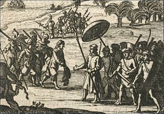
Sebald or Sebald de Weert was a Flemish captain and vice-admiral of the Dutch East India Company. He is most widely remembered for accurately plotting the Falkland Islands in 1600.

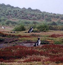
The striated caracara or Forster's caracara is a Near Threatened bird of prey of the family Falconidae, the falcons and caracaras. It is found in Argentina, Chile, and the Falkland Islands. In the Falklands it is known as the Johnny rook, probably named after the Johnny penguin.

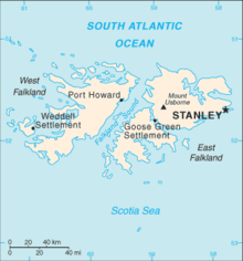
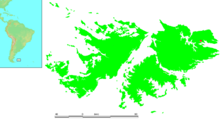
The Falkland Islands is an archipelago in the South Atlantic Ocean on the Patagonian Shelf. The principal islands are about 300 mi (480 km) east of South America's southern Patagonian coast and about 752 mi (1,210 km) from Cape Dubouzet at the northern tip of the Antarctic Peninsula, at a latitude of about 52°S. The archipelago, with an area of 4,700 sq mi (12,000 km2), comprises East Falkland, West Falkland, and 776 smaller islands. As a British overseas territory, the Falklands have internal self-governance, but the United Kingdom takes responsibility for their defence and foreign affairs. The capital and largest settlement is Stanley on East Falkland.
Bird Island is one of the Falkland Islands. It lies due south of West Falkland, near Port Stephens and Calm Head. It has been identified as an Important Bird Area (IBA) by BirdLife International.
The Falkland Islands have a complex history stretching over five hundred years. Active exploration and colonisation began in the 18th century but a self-supporting colony was not established till the latter part of the 19th century. Nonetheless, the islands have been a matter of controversy, as due to their strategic position in the 18th century their sovereignty was claimed by the French, Spaniards, British and Argentines at various points.

Duplicate: List of Falkland Islands–related topics
| Authority control databases: National |
|---|