
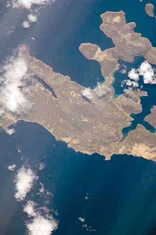
The Falkland Islands are located in the South Atlantic Ocean between 51°S and 53°S on a projection of the Patagonian Shelf, part of the South American continental shelf. In ancient geological time this shelf was part of Gondwana, and around 400 million years ago split from what is now Africa and drifted westwards from it. Today the islands are subjected to the Roaring Forties, winds that shape both their geography and climate.

Lively Island is the largest of the Lively Island Group of the Falkland Islands, The island group lies east of East Falkland. Lively Island is the largest rat-free island in the Falklands, hence its importance to birdlife. The island also has a sheep farm.

Bleaker Island is one of the Falkland Islands, lying off south east Lafonia. The name is a corruption of "Breaker Island" due to the waves that break on it. It was also known as "Long Island" at one point.

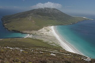
Carcass Island is the largest of the West Point Island Group of the Falkland Islands.
Beaver Island is one of the Beaver Island group of Falkland Islands. It lies west of Weddell Island and south of New Island and has an area of 4,856 hectares.
Saunders Island is the fourth largest of the Falkland Islands, lying north west of West Falkland. The island is run as a sheep farm.

The Jason Islands are an archipelago in the Falkland Islands, lying to the far north-west of West Falkland. Three of the islands, Steeple Jason, Grand Jason and Clarke's Islet, are private nature reserves owned by the Wildlife Conservation Society of New York City. Other islands in the group are National Nature Reserves owned by the Falkland Islands Government.

Pebble Island is one of the Falkland Islands, situated north of West Falkland. It is possibly named after the peculiarly spherical pebbles found at its western tip.

Sea Lion Island is the largest of the Sea Lion Island Group of the Falkland Islands. It is 9 km2 (3 sq mi) in area. and lies 14 km (9 mi) southeast of Lafonia. It was designated a Ramsar site on 24 September 2001., and as an Important Bird Area. In 2017 the island was designated as a National Nature Reserve.

New Island is one of the Falkland Islands, lying north of Beaver Island. It is 238 km (148 mi) from Stanley and is 13 km (8.1 mi) long with an average width of 750 m (820 yd). The highest point is 226 metres (741 ft). The northern and eastern coasts have high cliffs but the eastern coasts are lower lying, with rocky shores and sandy bays. There are several smaller offshore islands in the group; North Island and Saddle Island have high cliffs but Ship Island and Cliff Knob Island are lower lying.

West Point Island is one of the Falkland Islands, lying in the north-west corner of the archipelago. It has an area of 1,469 hectares (5.67 sq mi) and boasts some of the most spectacular coastal scenery in the Falklands. The island is owned by Roddy & Lily Napier and run as a sheep farm and tourist attraction.

Beauchene Island is the southernmost of the Falkland Islands, lying about 54 kilometres (34 mi) south of Porpoise Point in Lafonia. It was discovered in 1701 by Jacques Gouin de Beauchêne, after whom it was named.
Islas Ildefonso are a group of islands in Chile. The islands belong to the Commune of Cabo de Hornos in Antártica Chilena Province of Magallanes and Antártica Chilena Region. They lie 96 km (60 mi) west of Isla Hermite, part of Tierra del Fuego, and 93 km (58 mi) NNW of Diego Ramirez Islands, but only 27 km (17 mi) south of Isla Hoste or 23 km (14 mi) to rocks near Isla Hoste.

Kidney Island so called due to its shape, is a small island with a land area of 33 hectares, to the east of East Falkland, not far from Stanley. It lies is at the east end of Berkeley Sound near Kidney Cove, and is separated from Port William by Menguera Point. It is a nature reserve and, unlike most of the main islands, is still covered in tussac grass. Its wildlife includes penguins and sea lions. It is one of only three places in the archipelago where king penguins breed; the others are Saunders Island and Volunteer Point on East Falkland.

Bird Island is one of the Falkland Islands. It lies due south of West Falkland, near Port Stephens and Calm Head. It has been identified as an Important Bird Area (IBA) by BirdLife International.
Hummock Island is the largest of a group of islands in King George Bay in the Falkland Islands. It has a land area of 3.03 square kilometres (1.17 sq mi) and is about 4.0 miles (6.4 km) long in a north-west to south-east direction. Hummock Island is off the western coast of West Falkland, in a bay that leads to the estuary of the Chartres River. The highest point on the island is in the north-east and is 190 metres (620 ft). There are cliffs which often reach over 60 metres (200 ft) high.

Avian Island is an island, 1.2 km (0.7 mi) long and 40 metres (130 ft) high, lying close off the south tip of Adelaide Island, Antarctica. It was discovered by the French Antarctic Expedition, 1908–10, under Jean-Baptiste Charcot, and visited in 1948 by the Falkland Islands Dependencies Survey, who so named it because of the large number and variety of birds (avians) found there.

The Elephant Cays are a group of small islands lying towards the southern end of Falkland Sound, just to the north-west of Speedwell Island, in the Falkland Islands of the South Atlantic Ocean. The group, with a collective area of 248 ha includes Golden Knob, Sandy Cay, West, Southwest and Stinker Islands. It has been identified by BirdLife International as an Important Bird Area (IBA).
Hope Harbour is an inlet at the north-west of West Falkland in the Falkland Islands of the South Atlantic Ocean. About 4 km long and 1.3 km wide, it is sheltered by the promontory of Grave Cove Camp in the south, a narrow ridge terminating in Hope Point to the north, Bramble Point Camp to the east, and West Point Island at its entrance to the west. Carcass Island lies 8 km north-east of Hope Point.
Seal Bay is a bay, about 1 km across, on the rugged and exposed north coast of East Falkland in the Falkland Islands of the South Atlantic Ocean. It lies some 40 km north-west of Stanley.
