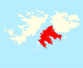
The Falkland Islands are located in the South Atlantic Ocean between 51°S and 53°S on a projection of the Patagonian Shelf, part of the South American continental shelf. In ancient geological time this shelf was part of Gondwana, and around 400 million years ago split from what is now Africa and drifted westwards from it. Today the islands are subjected to the Roaring Forties, winds that shape both their geography and climate.

Speedwell Island is one of the Falkland Islands, lying in the Falkland Sound, southwest of Lafonia, East Falkland.

Lafonia is a peninsula forming the southern part of East Falkland, the largest of the Falkland Islands.
Barren Island is one of the Falkland Islands, lying south west of East Falkland and south east of George Island. It is separated from Lafonia by Eagle Passage. Its total area is 11.5 square kilometres (4.4 sq mi).
George Island is the second largest of the Speedwell Island Group in the Falkland Islands with a land area of 24 square kilometres (9.3 sq mi). It lies south of Speedwell Island and south west of East Falkland, and is separated from Lafonia by Eagle Passage. The island is generally flat, rising no more than 18 metres (59 ft) above sea level, and there are several ponds and there is severe soil erosion in the central section. However, the island is free of rats.

The Falkland Sound is a sea strait in the Falkland Islands. Running southwest-northeast, it separates West and East Falkland.

The Scotia Plate is a minor tectonic plate on the edge of the South Atlantic and Southern oceans. Thought to have formed during the early Eocene with the opening of the Drake Passage that separates Antarctica and South America, it is a minor plate whose movement is largely controlled by the two major plates that surround it: the Antarctic Plate and the South American Plate. The Scotia Plate takes its name from the steam yacht Scotia of the Scottish National Antarctic Expedition (1902–04), the expedition that made the first bathymetric study of the region.

Choiseul Sound is a stretch of sea in the Falkland Islands. It runs parallel to Eagle Passage and is between Lafonia and the north of East Falkland. Lively Island is in its mouth. At its entrance, on the northern shore, is the Bertha's Beach Important Bird Area which is also a Ramsar site, recognising it as a wetland of international importance.

Brenton Loch is an inlet-cum-small fjord in the Falkland Islands. It is one of a handful of sea lochs outside Scotland. It is sometimes known as "Brenton Sound". "Loch" is normally pronounced as "lock" in the English rather than Scottish manner, i.e. without a fricative "ch". The far south of the loch is known as "La Boca" or "The Boca".

San Carlos Water is a bay/fjord on the west coast of East Falkland, facing onto the Falkland Sound.

Bull Point is the most southerly part of East Falkland, and of the two main islands of the Falklands. It is at the far end of Lafonia, near Eagle Passage, and forms part of the west shore of the Bay of Harbours. A 1500 ha tract has been identified by BirdLife International as an Important Bird Area (IBA).

The Bay of Harbours is a bay/fjord on the south east coast of East Falkland. It is in Lafonia between Eagle Passage and the Adventure Sound, and forms the lower segment of the "E" of the peninsula. North Arm is at its landward end.

The South American–Antarctic Ridge or simply American-Antarctic Ridge is the tectonic spreading center between the South American Plate and the Antarctic Plate. It runs along the sea-floor from the Bouvet Triple Junction in the South Atlantic Ocean south-westward to a major transform fault boundary east of the South Sandwich Islands. Near the Bouvet Triple Junction the spreading half rate is 9 mm/a (0.35 in/year), which is slow, and the SAAR has the rough topography characteristic of slow-spreading ridges.

Duplicate: List of Falkland Islands–related topics

The James Ross Island group is a group of islands located close to the northeastern tip of the Antarctic Peninsula. The largest islands in the group are James Ross Island, Snow Hill Island, Vega Island, and Seymour Island. The islands lie to the south of the Joinville Island group. The groups contains several scientific bases, notably Marambio Base, and numerous important palaeontological sites.

The Elephant Cays are a group of small islands lying towards the southern end of Falkland Sound, just to the north-west of Speedwell Island, in the Falkland Islands of the South Atlantic Ocean. The group, with a collective area of 248 ha includes Golden Knob, Sandy Cay, West, Southwest and Stinker Islands. It has been identified by BirdLife International as an Important Bird Area (IBA).

Gull Harbour is the 1.3 km wide bay indenting for 2.8 km the east coast of Weddell Island in the Falkland Islands. It is entered north of Gull Point and south of Mark Point, and is centred at 51°53′56″S60°53′20″W. The principal settlement of the island, Weddell Settlement, is situated at the head of the bay. Until the mid-nineteenth century Gull Harbour was known as Great Harbour.


