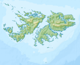
The Falkland Islands are located in the South Atlantic Ocean between 51°S and 53°S on a projection of the Patagonian Shelf, part of the South American continental shelf. In ancient geological time this shelf was part of Gondwana, and around 400 million years ago split from what is now Africa and drifted westwards from it. Today the islands are subjected to the Roaring Forties, winds that shape both their geography and climate.

Mount Usborne is a mountain on East Falkland. At 705 m (2,313 ft) above sea level, it is the highest point in the Falkland Islands. It is only 5 metres (16 ft) taller than Mount Adam, the highest peak on West Falkland.

A tarn is a mountain lake, pond or pool, formed in a cirque excavated by a glacier. A moraine may form a natural dam below a tarn.

Pebble Island is one of the Falkland Islands, situated north of West Falkland. It is possibly named after the peculiarly spherical pebbles found at its western tip.

An Teallach is a mountain group in Wester Ross, in the Northwest Highlands of Scotland. It lies west of Dundonnell Forest, north of Loch na Sealga, and south of Little Loch Broom. Its highest peaks are the Munros of Bidean a' Ghlas Thuill at 1062 m, and Sgùrr Fiona at 1058 m.
The Hornby Mountains are a mountain range on West Falkland in the Falkland Islands. Mount Maria is a mountain in this range. The range runs in a group of ridges parallel to Falkland Sound.

Mweelrea is a mountain on the Atlantic coast of County Mayo, Ireland. Rising to 814 metres (2,671 ft), it is the highest mountain in the western province of Connacht, and is noted for its southeastern cliff-lined corries, and its views. Mweelrea overlooks Killary Harbour and is at the heart of a "horseshoe-shaped" massif that includes the peaks of Ben Lugmore and Ben Bury. The massif is called the Mweelrea Mountains or the Mweelrea Range.

Port Stanley Airport, also merely known as Stanley Airport, is a small civil airport in the Falkland Islands, located two miles from the capital, Stanley. This airport is the only civilian airport in the islands with a paved runway. However, the military airbase at RAF Mount Pleasant, located to the west of Stanley, functions as the islands' main international airport, because it has a long runway capable of handling wide-body aircraft, and allows civilian flights by prior permission from the UK Ministry of Defence (MoD). Port Stanley Airport is owned by the Government of the Falkland Islands, operated by the Falkland Islands Government Air Service, and is used for internal flights between the islands and flights between the Falklands and Antarctica. It has two asphalt-paved runways; its main runway 09/27 is 918 by 19 metres, and its secondary runway 18/36 is 338 metres long.

Scotland is the most mountainous country in the United Kingdom. Scotland's mountain ranges can be divided in a roughly north to south direction into: the Scottish Highlands, the Central Belt and the Southern Uplands, the latter two primarily belonging to the Scottish Lowlands. The highlands eponymously contains the country's main mountain ranges, but hills and mountains are to be found south of these as well. The below lists are not exhaustive; there are countless subranges throughout the country.
Corrie is a village on the north east coast of the Isle of Arran in Scotland, 6 miles north of Brodick. It lies 2 mi (3 km) due east under the island's highest mountain, Goat Fell. A path from High Corrie 3⁄4 mi (1.2 km) to the south, provides access to the hillside. Corrie, and its northern neighbour, Sannox, lie approximately halfway between Brodick and Lochranza.
The Wickham Heights are a rugged chain of mountains on East Falkland in the Falkland Islands. They include the island group's highest peak, Mount Usborne, Mount Wickham and are partly contiguous with No Man's Land. The slopes of Wickham Heights feature numerous stone runs, some of them extending up to 5 km (3.1 mi).
Storm Mountain is on West Falkland in the Falkland Islands. It is 1,709 feet (521 m) high. Because of its location on a narrow peninsula jutting out into the South Atlantic, between Byron Sound and King George Bay, it is highly exposed, whence its name.
Mount Adam is a mountain on West Falkland, part of the Hill Cove Mountains range. It is the highest mountain on West Falkland and is the second highest in the islands. It has the remains of glacial cirques on it, and is only 5 metres (16 ft) lower than Mount Usborne, the highest peak of the Falkland Islands on East Falkland. Its summit is at 700 metres (2,300 ft). It is south west of Mount Edgeworth. The closest settlements are Hill Cove to the North, and Chartres to the South.

Binn idir an Dá Log, sometimes anglicized Benadolug, at 702 metres (2,303 ft), is the highest of the Maumturk Mountains in Connemara in County Galway, Ireland. It is at the middle of the long north-west to south-east central spine of the range. The summit is the 87th-highest peak in Ireland on the Arderin list, and the 108th-highest on the Vandeleur-Lynam list.

A stone run is a rock landform resulting from the erosion of particular rock varieties caused by freezing-thawing cycles in periglacial conditions during the last Ice Age.

The following outline is provided as an overview of and topical guide to the Falkland Islands:
Amphibolite Point is a conspicuous, pyramidal point 1.5 nautical miles (3 km) northwest of Saunders Point on the south coast of Coronation Island, in the South Orkney Islands. It was named by the Falkland Islands Dependencies Survey following their survey of 1948–49; there is a large amount of amphibolite on this point.

Mount Alice is a mountain rising to 361 m (1,180 ft) at the south extremity of West Falkland, Falkland Islands in the South Atlantic. It is situated between the bays of Port Stephens and Port Albemarle, 12.3 km (7.6 mi) due north of Cape Meredith.
Byron Heights is a mountain rising to 497 m (1,630 ft) at the northwest extremity of West Falkland, Falkland Islands in the South Atlantic. It is situated 11.65 km (7.24 mi) southeast of Hope Point.
Devils Peak is a conspicuous rocky peak, 735 m, between Sunshine Glacier and Devils Corrie on the south side of Coronation Island, in the South Orkney Islands. Surveyed in 1948-49 by the Falkland Islands Dependencies Survey (FIDS), who so named it because of its proximity to Devils Corrie.