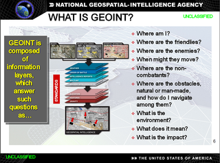
The National Geospatial-Intelligence Agency (NGA) is a combat support agency within the United States Department of Defense whose primary mission is collecting, analyzing, and distributing geospatial intelligence (GEOINT) in support of national security. Initially known as the National Imagery and Mapping Agency (NIMA) from 1996 to 2003, it is a member of the United States Intelligence Community.

The Gulf of Alaska is an arm of the Pacific Ocean defined by the curve of the southern coast of Alaska, stretching from the Alaska Peninsula and Kodiak Island in the west to the Alexander Archipelago in the east, where Glacier Bay and the Inside Passage are found.

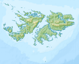
Mount Longdon is a hill located in the east of East Falkland island forming part of the Falkland Islands Archipelago. It has an elevation of 183 metres above sea level. It is the highest land in any direction for 3 kilometres. Mount Longdon is named after Lt Col Richard Longdon, who was the commanding officer of the 2nd Battalion, Parachute Regiment of the British Army during the Falklands War. It is best known as the site of the Battle of Mount Longdon, and overlooks Stanley, the capital of the Falkland Islands.

In the United States, geospatial intelligence (GEOINT) is intelligence about the human activity on Earth derived from the exploitation and analysis of imagery, signals, or signatures with geospatial information. GEOINT describes, assesses, and visually depicts physical features and geographically referenced activities on the Earth. GEOINT, as defined in US Code, consists of imagery, imagery intelligence (IMINT) and geospatial information.

Cape Alexander is a cape which forms the south end of Churchill Peninsula and the east side of the entrance to Cabinet Inlet, on the east coast of Graham Land. It was charted by the Falkland Islands Dependencies Survey (FIDS) and photographed from the air by the Ronne Antarctic Research Expedition (RARE) in December 1947.

Buck Island National Wildlife Refuge is located about 2 miles (4 km) south of the island of St. Thomas in the Virgin Islands of the United States. Adjacent to the refuge is Capella Island, about half the size of Buck, owned by the territorial government. There is a second Buck Island just north of St. Croix that is the centerpiece of Buck Island Reef National Monument.

Arrowsmith Peninsula is a cape about 40 miles (64 km) long on the west coast of Graham Land, west of Forel Glacier, Sharp Glacier and Lallemand Fjord, and northwest of Bourgeois Fjord, with Hanusse Bay lying to the northwest. It was surveyed by the Falkland Islands Dependencies Survey (FIDS) in 1955-58 and named for Edwin Porter Arrowsmith, Governor of the Falkland Islands.
Smoko Mount is a hill on East Falkland, Falkland Islands. "Smoko" is Falkland Islands English for a smoking break.

The Chiloango River is a river in western Central Africa. It forms the westernmost part of the border between the Democratic Republic of the Congo and the Republic of Congo, and then forms approximately half of the border between the DRC and Cabinda, Angola passing just south of the town of Necuto. The river then bisects Cabinda, making it the most important river in the province. It enters the Atlantic Ocean just north of the town of Cacongo.
Cacongo is a town, with a population of 15,000 (2014), in Cacongo municipality, Cabinda Province, in Angola. The former Lândana municipality is now known as Cacongo, and the town is sometimes still known as Lândana. It is located on Lândana Bay about a kilometer south of the mouth of the Chiloango River.
The Tudjuh Archipelago is a large group of islands in north-western Indonesia, off the west and north-west coast of the island of Borneo in the South China Sea. Administratively the islands belong to the Riau Islands province of Indonesia. The Tudjuh Archipelago consists of four island groups, the Badas Islands, the Tambelan Islands, the Natuna Islands, and the Anambas Islands. The south-westernmost extent of the archipelago is 1°4′S105°10′E.
Collins Point is a small but prominent headland 1.4 km (0.87 mi) west-south-west of Fildes Point, on the south side of Port Foster, Deception Island, in the South Shetland Islands of Antarctica. It was charted by a British expedition under Foster, 1828–31. It was named by Lieutenant Commander D.N. Penfold, Royal Navy, following his survey of the island in 1948–49, for Rear Admiral Kenneth Collins of the Hydrographic Department of the Admiralty.
Suffield Point is the south-west entrance point of Norma Cove, Fildes Peninsula, on King George Island in the South Shetland Islands of Antarctica. It was charted in the course of the Discovery Investigations, 1933–35, and named after boatswain William E. Suffield. The site is part of the Fildes Peninsula Antarctic Specially Protected Area, designated as such because of its paleontological values.

Cape Lloyd is a cape which forms the north end of Clarence Island in the South Shetland Islands of Antarctica, on the north side of the entrance to Kutela Cove. The name "Lloyd's Promontory" appears on charts of the 1821–1825 period, but in more recent years the feature has become internationally known as Cape Lloyd.

Richthofen Pass is a pass, 1 nautical mile (1.9 km) wide, between Mount Fritsche and the rock wall north of McCarroll Peak, on the east coast of Graham Land. Discovered and photographed in 1902 by the Swedish Antarctic Expedition under Nordenskjold, who named it Richthofen Valley for Baron Ferdinand von Richthofen, German geographer and geologist. The feature was found to be a pass by the Falkland Islands Dependencies Survey (FIDS) in 1955.
Alyabiev Glacier is a glacier in Antarctica, flowing south from Gluck Peak into Boccherini Inlet and lies about 3 miles (5 km) West of Arensky Glacier on Beethoven Peninsula, Alexander Island, It was named by the USSR Academy of Sciences, in 1987, after Alexander Alyabiev (1787-1851), the Russian composer.
The Burdwood Bank, called Namuncurá in Argentina and other countries, is an undersea bank with a prominence of approximately 200 metres, part of the Scotia Arc projecting some 600 km (370 mi) from Cape Horn in the South Atlantic Ocean and located some 200 kilometres (120 mi) south of the Falkland Islands. Argentina claims economic rights over the whole of the bank, while the United Kingdom has designated about half of the bank as part of the Falklands Outer Economic Zone.


