Lafonia

Last updated

Location of Lafonia within the Falkland Islands. Locator map of Lafonia in the Falkland Islands.svg
Location of Lafonia within the Falkland Islands.

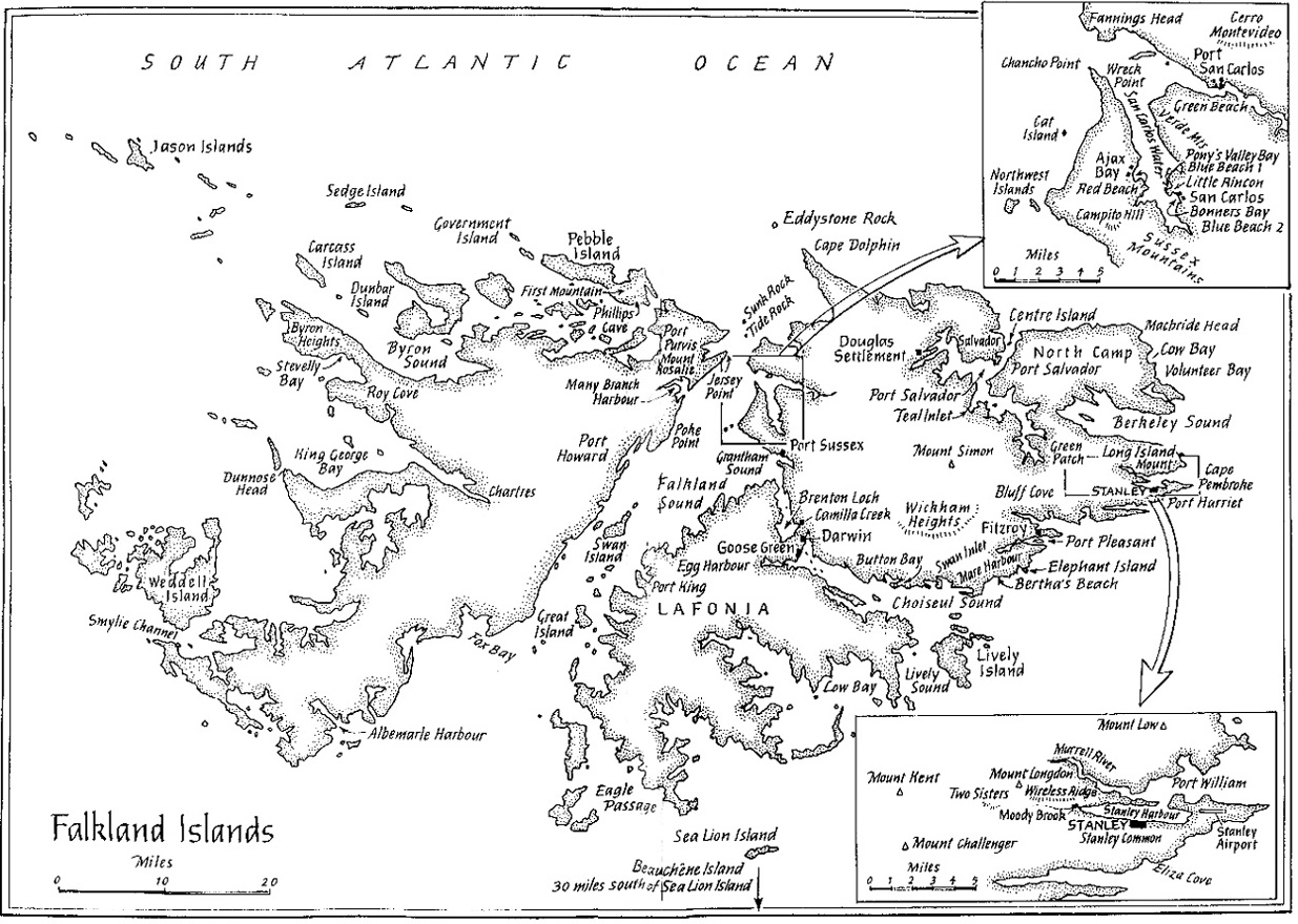
Lafonia is a peninsula forming the southern part of East Falkland, the largest of the Falkland Islands.

Contents

Geography and geology

Map of the Falkland Islands. Falkland Islands topographic map-en.svg
Map of the Falkland Islands.

Shaped like the letter "E", it is joined to the northern part of the island by an isthmus that is almost 2.5 kilometres (1.6 mi) wide. [1] Were this isthmus to be severed, Lafonia would be the third largest of the Falkland Islands. Falkland Sound runs to the west between Lafonia and West Falkland. Choiseul Sound divides Lafonia from the northern part of East Falkland, which is still unnamed.

Barren Island, Bleaker Island, George Island, Lively Island, Sea Lion Island and Speedwell Island are all off Lafonia.

The geology of north west Lafonia is Permian, and similar to that of parts of Ecca Pass in South Africa. [2] The plain of Lafonia is constituted by arenaceous sediments of the Lafonia Group. Depressions in the sediments formed where they were cut vertically by basalt dikes.

In the 21st century, Lafonia has seen gold prospecting by Falkland Gold and Minerals Ltd. [3]

History and population

Falkland gauchos having mate at Hope Place - Saladero, East Falkland. Watercolour by Dale, manager of Hope Place in the 1850s. Hope-Place.jpg
Falkland gauchos having mate at Hope Place - Saladero, East Falkland. Watercolour by Dale, manager of Hope Place in the 1850s.

The land is gentle and low-lying, but almost uninhabited, falling into the "camp" category. Most of its settlement occurred in the mid 19th century.

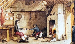
In 1845, Mr Samuel Fisher Lafone, a British-born wealthy cattle and hide merchant on the river Plate, obtained from government a grant of the southern portion of the East Falkland, which was a peninsula 600,000 acres (2,400 km2) in extent, and possession of all the wild cattle on the island for a period of six years, for a payment of £10,000 down, and £20,000 in ten years from January 1, 1852. In 1851, Mr Lafone's interest in Lafonia, as the peninsula came to be called, was purchased for £30,000 by the Falkland Islands Company, which had been incorporated by charter in the same year.

Lafonia has been used for sheep farming since the early nineteenth century. It is run from Darwin (founded 1859) and Goose Green, both of which are located on the narrow isthmus that separates Lafonia from the rest of East Falkland. North Arm Settlement is the only substantial settlement in Lafonia (not counting offshore islands), along with Walker Creek. Attractions include the Bodie Suspension Bridge, built in 1925 and said to be the southernmost in the world. There is also a shop here. Listed buildings in Lafonia include The Galpon and Stone Corral in Darwin, The Stone Cottage and Goose Green Hall (owned by Falklands Landholdings) in Goose Green and Paragon House. [4]

The first battles on land during the Falklands War took place on Lafonia (see Battle of Goose Green), where over a thousand Argentine personnel were stationed and around one-hundred locals were imprisoned in the community hall. The area is now home to an Argentine Military Cemetery. Parts of Lafonia, especially near Darwin and Goose Green, are still heavily mined.

Other settlements include Port King, Egg Harbour and the abandoned Hope Place.

Wildlife

Charles Darwin surveyed the area's wildlife during his now-famous voyage on HMS Beagle.

Lafonia's wildlife includes the Chiloé wigeon, silver teal and yellow-billed pintail. Introduced brown trout are found in at least one stream flowing into Choiseul Sound. [5] There is also a population of zebra trout.

See also

Related Research Articles

History of the Falkland Islands

The history of the Falkland Islands goes back at least five hundred years, with active exploration and colonisation only taking place in the 18th century. Nonetheless, the Falkland Islands have been a matter of controversy, as they have been claimed by the French, British, Spaniards and Argentines at various points.

Geography of the Falkland Islands Geography of the Falkland Islands

The Falkland Islands are located in the South Atlantic Ocean between 51°S and 53°S on a projection of the Patagonian Shelf, part of the South American continental shelf. In ancient geological time this shelf was part of Gondwana, and around 400 million years ago split from what is now Africa and drifted westwards from it. Today the islands are subjected to the Roaring Forties, winds that shape both their geography and climate.

Battle of Goose Green Battle of the Falklands War in May 1982

The Battle of Goose Green was fought May 28–29, 1982, by British and Argentine forces during the Falklands War. Located on East Falkland's central isthmus, the settlement of Goose Green was the site of an airfield. Argentine forces were in a well-defended position, within striking distance of San Carlos Water, where the British task force had made its amphibious landing.

East Falkland Island in Falkland Islands, Atlantic Ocean

East Falkland is the largest island of the Falklands in the South Atlantic, having an area of 6,605 km2 or 54% of the total area of the Falklands. The island consists of two main land masses, of which the more southerly is known as Lafonia; it is joined by a narrow isthmus where the settlement of Goose Green is located, and it was the scene of the Battle of Goose Green during the Falklands War.

Darwin, Falkland Islands Place in Falkland Islands

Darwin is a settlement in Lafonia on East Falkland, Falkland Islands, lying on Choiseul Sound, on the east side of the island's central isthmus, 2.5 miles (4.0 km) north of Goose Green. It was known occasionally as Port Darwin.

Goose Green Place in Falkland Islands, United Kingdom

Goose Green is a settlement in Lafonia on East Falkland in the Falkland Islands. It lies on Choiseul Sound, on the east side of the island's central isthmus, 2 miles (3.2 km) south-southwest of Darwin. With a population of about 40, it is the third-largest settlement of the Falkland Islands, after Stanley and Mount Pleasant.

Camp (Falkland Islands)

The Camp is the term used in the Falkland Islands to refer to any part of the islands outside the islands' only significant town, Stanley, and often the large RAF base at Mount Pleasant. It is derived from the Spanish word campo, for "countryside".

The Bodie Creek Suspension Bridge in the Falkland Islands is one of the southernmost suspension bridges in the world. It was built in 1925, from a kit fabricated in England by David Rowell & Co., in order to shorten the distance sheep needed to be driven from southern Lafonia to the shearing sheds in Goose Green.

Choiseul Sound

Choiseul Sound is a stretch of sea in the Falkland Islands. It runs parallel to Eagle Passage and is between Lafonia and the north of East Falkland. Lively Island is in its mouth. At its entrance, on the northern shore, is the Bertha's Beach Important Bird Area which is also a Ramsar site, recognising it as a wetland of international importance.

Brenton Loch

Brenton Loch is an inlet-cum-small fjord in the Falkland Islands. It is one of a handful of sea lochs outside Scotland. It is sometimes known as "Brenton Sound". "Loch" is normally pronounced as "lock" in the English rather than Scottish manner, i.e. without a fricative "ch". The far south of the loch is known as "La Boca" or "The Boca".

Hope Place

Hope Place was a small settlement in Lafonia in East Falkland. It was set up in 1846, by Samuel Lafone, a British-born Montevideo merchant, on the south shores of Brenton Loch. It was mainly populated by Uruguayan gauchos brought in from continental South America. The area is now abandoned.

Walker Creek is a settlement on East Falkland, in the Falkland Islands, in Lafonia. It is on the shore of the Choiseul Sound, and overlooks Sea Lion Island in the distance. It is the second largest settlement on East Falkland south of Goose Green, after North Arm.

Adventure Sound

Adventure Sound is a bay/fjord on the south east coast of East Falkland. It is in Lafonia between Choiseul Sound and the Bay of Harbours, and forms the upper segment of the "E" of the peninsula.

Eagle Passage Strait in the Falkland Islands

Eagle Passage is a strait in the Falkland Islands, between Lafonia in the southwest of East Falkland, and the smaller islands of Speedwell, Barren and George Island. George Island and Speedwell Island form the stretch of land to the south of the passage while East Falkland forms the northern stretch. The passage is difficult to navigate as ships may founder on the reefs and kelp lying off the surrounding islands.

Egg Harbour is a location in Lafonia on East Falkland. It faces onto Falkland Sound. There are a few buildings here, some of them abandoned.

Tabarin Peninsula is a peninsula 15 nautical miles (28 km) long and 5 to 12 nautical miles (22 km) wide, lying south of the trough between Hope Bay and Duse Bay and forming the east extremity of Trinity Peninsula in the Antarctic Peninsula. It was discovered and charted by the Swedish Antarctic Expedition, 1901–1904, led by Otto Nordenskjöld and Carl Anton Larsen. It was mapped in 1946 by the Falkland Islands Dependencies Survey (FIDS) and named after Operation Tabarin, the naval code name for the FIDS from 1943 to 1945.

Samuel Fisher Lafone was a British-born Uruguayan businessman.

Bodie Creek, also called Bodie Inlet, is the estuary of Orqueta Creek and other small streams into Choiseul Sound, located south of the settlement of Goose Green in Lafonia, in the centre of East Falkland, Falkland Islands.

References

  1. P Turnbull (20 March 2004). "Falkland Islands". South Seas: South Seas Companion. Retrieved 5 March 2010.
  2. "Stratigraphy and sedimentology of the Permian of the Falkland Islands: Lithostratigraphic and palaeoenvironmental links with South Africa". Journal of the Geological Society. 2002. Archived from the original on 7 April 2011.
  3. "'Best practice' approach to drilling, minerals company assures Falklands". Penguin News Update. MercoPress. 8 April 2005. Archived from the original on 24 April 2005.
  4. "Buildings and Structures in the Falkland Islands designated as being of Architectural or Historic Interest". Falkland Islands Information Web Portal. Archived from the original on 28 July 2012. Retrieved 1 September 2012.
  5. McDowall, R. M. (2001). "Conserving and Managing the Falkland Islands Freshwater Fishes". The Falkland Islands Journal . 7 (5). Archived from the original on 7 December 2006.

Coordinates: 52°00′28″S59°23′38″W / 52.00778°S 59.39389°W / -52.00778; -59.39389