Lively Island

Last updated

Lively Island
Isla Bougainville
Lively Island - Falkland Islands.jpg
Falkland Islands location map.svg
Red pog.svg
Lively Island
Lively Island shown within the Falkland Islands
Coordinates: 52°01′46″S58°28′01″W / 52.02944°S 58.46694°W / -52.02944; -58.46694 Coordinates: 52°01′46″S58°28′01″W / 52.02944°S 58.46694°W / -52.02944; -58.46694
Country Falkland Islands
Island groupLively Island Group
Area
  Total55.85 km2 (21.56 sq mi)
Highest elevation
37 m (121 ft)
Time zone UTC−3 (FKST)
If shown, area and population ranks are for all islands and all inhabited islands in the Falklands respectively.
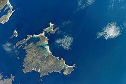
Lively Island (Spanish : Isla Bougainville) is the largest of the Lively Island Group of the Falkland Islands, The island group lies east of East Falkland. Lively Island is the largest rat-free island in the Falklands, hence its importance to birdlife. The island also has a sheep farm.

Contents

History

The Spanish name, "Isla Bougainville" (like Port Louis) is named after the French navigator Louis de Bougainville who established the first settlement in the archipelago in the 1760s.

In the late 19th and early 20th centuries the island was owned by George Cobb. It was sold after World War I to pay taxes.

In the Falklands War the Battle of Seal Cove took place near Lively Island. Seal Cove is a bay in East Falkland directly to the west of the island.

Description

Lively Island has an area of 5,585 hectares (13,800 acres). Its highest point is 37 metres (121 ft). There are several streams and ponds, the largest of which is Enderby Pond, 7 hectares (17 acres), an important waterfowl site. Lively is rat-free but with a century and a half of grazing little tussac grass remains and there are many large patches of eroded ground. [1]

Lively Island is surrounded by other, smaller islands and islets in the Lively Island group. Some of these Islets are linked to Lively Island by sandbars. [1] North East Island which is just 350 metres (380 yd) [1] off the coast of Lively, was the site of a rat eradication programme in 2003. (The rest of the Lively islands are rat free.)

Important Bird Area

The Lively Island group has been identified by BirdLife International as an Important Bird Area. Birds for which the site is of conservation significance include Falkland steamer ducks, ruddy-headed geese, gentoo penguins (650 breeding pairs), Magellanic penguins, southern giant petrels (40 pairs), white-bridled finches, blackish cinclodes and Cobb's wrens. [1]

Related Research Articles

Speedwell Island

Speedwell Island is one of the Falkland Islands, lying in the Falkland Sound, southwest of Lafonia, East Falkland.

Bleaker Island Island in Falkland Islands

Bleaker Island is one of the Falkland Islands, lying off south east Lafonia. The name is a corruption of "Breaker Island" due to the waves that break on it. It was also known as "Long Island" at one point.

Carcass Island Island in Falkland Islands

Carcass Island is the largest of the West Point Island Group of the Falkland Islands.

Beaver Island, Falkland Islands Island in Falkland Islands

Beaver Island is one of the Beaver Island group of Falkland Islands. It lies west of Weddell Island and south of New Island and has an area of 4,856 hectares.

Saunders Island, Falkland Islands Island in Falkland Islands

Saunders Island is the fourth largest of the Falkland Islands, lying north west of West Falkland. The island is run as a sheep farm.

Keppel Island is one of the Falkland Islands, lying between Saunders and Pebble islands, and near Golding Island to the north of West Falkland on Keppel Sound. It has an area of 3,626 hectares and its highest point, Mt. Keppel, is 341 metres (1,119 ft) high. There is a wide, flat valley in the centre of the island with several freshwater lakes. The central valley rises steeply to the south-west, west and north. The north-east is low-lying, with a deeply indented coastline.

Jason Islands

The Jason Islands are an archipelago in the Falkland Islands, lying to the far north-west of West Falkland. Three of the islands, Steeple Jason, Grand Jason and Clarke's Islet, are private nature reserves owned by the Wildlife Conservation Society of New York City. Other islands in the group are National Nature Reserves owned by the Falkland Islands Government.

Pebble Island Island in Falkland Islands

Pebble Island is one of the Falkland Islands, situated north of West Falkland. It is possibly named after the peculiarly spherical pebbles found at its western tip.

Sea Lion Island Island in Falkland Islands

Sea Lion Island is the largest of the Sea Lion Island Group of the Falkland Islands. It is 9 km2 (3 sq mi) in area. and lies 14 km (9 mi) southeast of Lafonia. It was designated a Ramsar site on 24 September 2001, and as an Important Bird Area. In 2017 the island was designated as a National Nature Reserve.

New Island Island in Falkland Islands

New Island is one of the Falkland Islands, lying north of Beaver Island. It is 238 km (148 mi) from Stanley and is 13 km (8.1 mi) long with an average width of 750 m (820 yd). The highest point is 226 metres (741 ft). The northern and eastern coasts have high cliffs but the eastern coasts are lower lying, with rocky shores and sandy bays. There are several smaller offshore islands in the group; North Island and Saddle Island have high cliffs but Ship Island and Cliff Knob Island are lower lying.

West Point Island Island in Falkland Islands

West Point Island is one of the Falkland Islands, lying in the north-west corner of the archipelago. It has an area of 1,469 hectares (5.67 sq mi) and boasts some of the most spectacular coastal scenery in the Falklands. The island is owned by Roddy & Lily Napier and run as a sheep farm and tourist attraction.

Beauchene Island Island in Falkland Islands

Beauchene Island is the southernmost of the Falkland Islands, lying about 54 kilometres (34 mi) south of Porpoise Point in Lafonia. It was discovered in 1701 by Jacques Gouin de Beauchêne, after whom it was named.

Seal Islands (South Shetland Islands) Islands of Antarctica

The Seal Islands are a group of small islands and rocky islets lying about 7 km north and north-west of Elephant Island, in the South Shetland Islands of Antarctica. They extend east–west for about 5 km, and are separated from Elephant Island by Sealers Passage. The group takes its name from the largest island, which Captain William Smith named Seal Island in 1820 because of the number of seals killed there.

The Ringgold Isles are an archipelago in Fiji, forming an outlier group to Vanua Levu. The Budd, Nukusemanu, and Heemskercq Reefs form part of the group. The group is mostly uninhabited, but Qelelevu has a small village. In 2008 Pacific Rats were eradicated from seven islands of the group in an endeavour facilitated by BirdLife International's Fiji Programme.

Passage Islands Island in Falkland Islands

The Passage Islands are a group of four islands in the Falkland Islands of the South Atlantic Ocean. They lie off Dunnose Head, West Falkland, at the mouth of King George Bay.

Kidney Island Island in Falkland Islands

Kidney Island so called due to its shape, is a small island with a land area of 33 hectares, to the east of East Falkland, not far from Stanley. It lies is at the east end of Berkeley Sound near Kidney Cove, and is separated from Port William by Menguera Point. It is a nature reserve and, unlike most of the main islands, is still covered in tussac grass. Its wildlife includes penguins and sea lions. It is one of only three places in the archipelago where king penguins breed; the others are Saunders Island and Volunteer Point on East Falkland.

Needle Rocks

The Needle Rocks, also known as the Needles, are a group of five main rock islets located close to the south-western coast of Tasmania, Australia. With a combined area of approximately 10.5 hectares (0.041 sq mi), the islets are part of the Maatsuyker Islands Group, and comprise part of the Southwest National Park and the Tasmanian Wilderness World Heritage Site.

Hummock Island is the largest of a group of islands in King George Bay in the Falkland Islands. It has a land area of 3.03 square kilometres (1.17 sq mi) and is about 4.0 miles (6.4 km) long in a north-west to south-east direction. Hummock Island is off the western coast of West Falkland, in a bay that leads to the estuary of the Chartres River. The highest point on the island is in the north-east and is 190 metres (620 ft). There are cliffs which often reach over 60 metres (200 ft) high.

Seal Bay is a bay, about 1 km across, on the rugged and exposed north coast of East Falkland in the Falkland Islands of the South Atlantic Ocean. It lies some 40 km north-west of Stanley.

References

  1. 1 2 3 4 "Lively Island Group". Important Bird Areas factsheet. BirdLife International. 2012. Retrieved 13 October 2012.